Seto is a city in Aichi Prefecture, Japan. As of 1 October 2019, the city had an estimated population of 127,659 in 56,573 households, and a population density of 1,146 persons per km2. The total area was 111.40 square kilometres (43.01 sq mi).

Aichi is a rural district located just east of Nagoya in central western Aichi Prefecture, Japan.

JOCH-DTV, branded as Chukyo TV, is the Chūkyō metropolitan area flagship station of the Nippon News Network and Nippon Television Network System (NNS), owned by the Chukyo TV. Broadcasting Co., Ltd.. Its studios are located in Nakamura-ku, Nagoya, Japan.

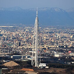
The Chubu Electric MIRAI TOWER is a TV tower in Nagoya, central Japan.

Chubu-Nippon Broadcasting Co., Ltd. is a regional radio and television service serving Nagoya, Aichi Prefecture, Japan. It is majorly owned by the Chunichi Shimbun. Its radio service is affiliated with the Japan Radio Network (JRN) and its television service affiliated with the Japan News Network (JNN).
Kaoru Usui was a Japanese photographer known for photographing children and the life of Nagoya and environs.

The Shōnai River is a Class 1 river flowing through Gifu and Aichi prefectures in Japan. In Gifu Prefecture, it is also referred to as the Toki River ; around the city of Kasugai in Aichi Prefecture, it is referred to as the Tamano River. Fujimae-higata exists in the River mouth.

Mount Mikuni is the name of three mountains in Gifu Prefecture, Japan. One of the mountains is on the border of Gifu and Aichi prefectures. Another mountain is on the border of Gifu and Nagano prefectures. The third mountain is located on the border of all three prefectures. All three mountains are included in this article.

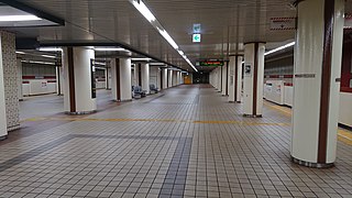
Sakae Station is an underground metro station located in Naka-ku, Nagoya, Aichi Prefecture, Japan operated by the Nagoya Municipal Subway. It is an interchange station between the Higashiyama Line and the Meijō Line and is located 9.0 rail kilometers from the terminus of the Higashiyama Line at Takabata Station and 3.0 rail kilometers from the terminus of the Meijō Line at Kanayama Station.

Shinsakae-machi Station is a subway station of the Nagoya Municipal Subway in Higashi-ku, Nagoya, Aichi Prefecture, Japan

Kamiyashiro Station is an above ground metro station located in Meitō-ku, Nagoya, Aichi Prefecture, Japan operated by the Nagoya Municipal Subway's Higashiyama Line. It is located 18.6 rail kilometers from the terminus of the Higashiyama Line at Takabata Station. This station provides access to Nagoya University of Arts and Sciences.

Hongō Station is an above ground metro station located in Meitō-ku, Nagoya, Aichi Prefecture, Japan operated by the Nagoya Municipal Subway's Higashiyama Line. It is located 19.3 rail kilometers from the terminus of the Higashiyama Line at Takabata Station.

Fujigaoka Station is a railway station in Meitō-ku, Nagoya, Aichi Prefecture, Japan

Sengen-chō Station is a railway station in Nishi-ku, Nagoya, Aichi Prefecture, Japan.

Hirabari Station is an underground metro station located in Tempaku-ku, Nagoya, Aichi Prefecture, Japan operated by the Nagoya Municipal Subway's Tsurumai Line. It is located 19.3 rail kilometers from the terminus of the Tsurumai Line at Kami-Otai Station. Near this station is the Aichi Driver's License Examination Center.

Hisaya-ōdōri Station is an underground metro station located in Naka-ku, Nagoya, Aichi Prefecture, Japan operated by the Nagoya Municipal Subway. It is an interchange station between the Sakura-dōri Line and the Meijō Line and is located 3.3 rail kilometers from the terminus of the Sakura-dōri Line at Taiko-dori Station and 3.4 rail kilometers from the terminus of the Meijō Line at Kanayama Station.

Ōzone Station is a railway station in Kita-ku, Nagoya, Aichi Prefecture, Japan. It is the largest transport hub in Northeastern Nagoya, connecting the JR Chuo Line, Meitetsu Seto Line, Meijo Subway Line, and Yutorito Nagoya guideway bus line. There are no internal connecting passages between the different lines which share the station, so it is necessary to exit the ticket gate and move between them outside. Daily passenger numbers exceed 100,000.
Takaoka Station is a railway station in Higashi-ku, Nagoya, Aichi Prefecture, Japan, operated by the Transportation Bureau City of Nagoya.

Sakae (栄) is an area in Naka-ku, Nagoya, Aichi, Japan. It refers to the areas around Sakae intersection, Sakae Station on the Nagoya Municipal Subway and Sakae Station on the Meitetsu Seto Line. Sakae is in the heart of Nagoya and is, along with Nagoya Station, one of Nagoya's main commercial districts.

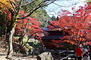
Kenchū-ji (建中寺) is a Jōdo-shū Buddhist temple in Tsutsui, Higashi-ku, Nagoya, central Japan. Starting in the Edo period, the mausoleums of the lords of the Owari Domain were located there, making it the Bodaiji of the Owari Tokugawa family.
