Seven Mountains (Bergen)

Last updated
Mountains of Bergen. Mountains of Bergen Norway.JPG
Mountains of Bergen.

The Seven Mountains (Norwegian : De syv fjell) are seven mountains that surround the centre of the city of Bergen in Vestland county, Norway. Bergen is often called 'the city between the seven mountains'.

Selection

Playwright Ludvig Holberg (1684–1754) felt so inspired by the Seven hills of Rome, he decided that his home town must also be blessed with a corresponding seven mountains. Which mountains belong to the group is unclear, due to its origin (based on the mythical status of the number seven), and the fact that several of the mountains are part of the same mountain massif. [1]

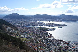
Since there are many mountains surrounding Bergen, the definition of the "seven mountains" varies depending on who is defining it. The Bergen Mountain Hiking Association, which organizes an annual 7-mountain hike defines it as Ulriken, Løvstakken, Fløyfjellet, Damsgårdsfjellet, Lyderhorn, Rundemannen, and Sandviksfjellet. [2] The list always includes these four main mountains plus three others:

Related Research Articles

<span class="mw-page-title-main">Bergen</span> City and municipality in Vestland, Norway

Bergen, historically Bjørgvin, is a city and municipality in Vestland county on the west coast of Norway. As of 2022, its population was roughly 289,330. Bergen is the second-largest city in Norway after the national capital Oslo. The municipality covers 465 square kilometres (180 sq mi) and is located on the peninsula of Bergenshalvøyen. The city centre and northern neighbourhoods are on Byfjorden, 'the city fjord'. The city is surrounded by mountains, causing Bergen to be called the "city of seven mountains". Many of the extra-municipal suburbs are on islands. Bergen is the administrative centre of Vestland county. The city consists of eight boroughs: Arna, Bergenhus, Fana, Fyllingsdalen, Laksevåg, Ytrebygda, Årstad, and Åsane.

<span class="mw-page-title-main">Årstad, Bergen</span> Borough in Western Norway, Norway

Årstad is a borough in the city of Bergen in Vestland county, Norway. Historically, the area was a separate municipality called Årstad until 1916, when it was merged into the city of Bergen. The borough has similar boundaries to those of the old municipality.

<span class="mw-page-title-main">Bergen Line</span> Railway line in Norway

The Bergen Line, or the Bergen Railway, is a 371-kilometre (231 mi) long scenic standard gauge railway line between Bergen and Hønefoss, Norway. The name is often applied for the entire route from Bergen via Drammen to Oslo, where the passenger trains go, a distance of 496 kilometres (308 mi). It is the highest mainline railway line in Northern Europe, crossing the Hardangervidda plateau at 1,237 metres (4,058 ft) above sea level.

<span class="mw-page-title-main">Fløyen</span> Mountain in Bergen, Norway

Fløyen or Fløyfjellet is one of the "city mountains" in Bergen, Hordaland, Norway. Its highest point is 400 m (1,300 ft) above sea level. The name could originate from fløystangen or a weather vane that was set up to indicate the direction of the wind for sailing ships. The view of the Bergen peninsula makes Fløyfjellet a popular attraction among tourists and locals alike. It has a funicular system called Fløibanen that transports passengers from the center of Bergen to a height of 320 m (1,050 ft) in roughly eight minutes.

<span class="mw-page-title-main">Ulriken</span>

Ulriken is the highest of the Seven Mountains that surround the city of Bergen, Norway. It has a height of 643 metres (2,110 ft) above sea level. Ulriken has an aerial tramway, Ulriksbanen, that can bring people to the top. At the top there is a TV tower and a restaurant. There is a network of trails along Ulriken, which is a popular hike with several paths up ranging from steep to not so steep.

<span class="mw-page-title-main">Laksevåg</span> Borough in Western Norway, Norway

Laksevåg is a borough of the city of Bergen in Vestland county, Norway. The borough is located in the western part of the municipality. Historically, the area was called Laxevaag, and it was a separate municipality until 1972 when it was merged into Bergen.

<span class="mw-page-title-main">Lyderhorn</span> Mountain in Bergen, Norway

Lyderhorn is a mountain in the city of Bergen in Vestland county, Norway. It is one of "De syv fjell", the seven mountains surrounding the city centre, and the starting location of Bergen Turlag's annual trip of the mountains. It is located by Liavatnet approximately 5 kilometres (3.1 mi) west of the city center. Due to its prominent visibility from the seas, it has historically been a navigational mark for sailors. The 329-metre (1,079 ft) tall Ørnafjellet is an adjacent peak, and below Ørnafjellet are the two lakes Skåleviksvatnet and Søre Skåleviksvatnet. North of Ørnafjellet is Kvarven fort, a strategic point during World War II, still featuring several bunkers and cannon positions used in the defense of Bergen. Lyderhorn, Ørnafjellet and Kvarven are popular hiking areas.

<span class="mw-page-title-main">Bergen landdistrikt</span> Former municipality in Hordaland, Norway

Bergen landdistrikt is a former municipality in the old Hordaland county in Norway. The municipality existed from 1838 until 1877 when it was merged into the neighboring city of Bergen. Bergen landdistrikt encompassed about 5 square kilometres (1.9 sq mi) of land surrounding the city of Bergen, including the present neighborhoods of Møhlenpris, Nygård, Kalfaret, Sandviken, and Ytre Sandviken as well as the mountains Fløyfjellet and Sandviksfjellet.

<span class="mw-page-title-main">Ulriken Tunnel</span> Railway tunnel in Bergen, Norway

The Ulriken Tunnel is a railway tunnel on the Bergen Line between Bergen Station and Arna Station in Bergen Municipality in Vestland county, Norway.

<span class="mw-page-title-main">Sandviksfjellet</span> Mountain in Bergen, Norway

Sandviksfjellet is a mountain in the city of Bergen in Vestland county, Norway. It is one of the traditional seven mountains that surround the city centre of Bergen. The mountain lies on the east side of the city neighborhood of Sandviken, just north of the mountain Fløyen. The European route E39 highway runs through the mountain as part of the Fløyfjell Tunnel.

<span class="mw-page-title-main">Rundemanen</span> Mountain in Bergen, Norway

Rundemanen is a mountain in the city of Bergen in Vestland county, Norway. It is considered one of the "seven mountains" which surround the city centre of Bergen. At 568 metres (1,864 ft) in height, it is the second highest of them all. It's a part of the same massif as the neighboring mountains of Fløyen, Blåmanen, and Ulriken, but not easily visible from the city center since it sits behind Fløyen.

<span class="mw-page-title-main">Ulriksbanen</span> Aerial tramway in Bergen, Norway

Ulriksbanen is a passenger aerial tramway in Bergen, Norway. It connects the mountain Ulriken to the city, and is frequently used by tourists as well as locals. The tramway was first thought of by Frithjof Meidell Andersen in 1954, and a company was established in 1959. After having been constructed by a Swiss company, Ulriksbanen opened in 1961. Ulriksbanen, branded as Ulriken643, in reference to the height of Mount Ulriken, opened with a new cable car and new bigger Skyskraperen restaurant in October 2021.

<span class="mw-page-title-main">Svartediket</span> Lake in Bergen, Norway

Svartediket is a lake in the city of Bergen in Vestland county, Norway. The 0.5-square-kilometre (0.19 sq mi) lake lies immediately north of the mountain Ulriken, northeast of the Store Lungegårdsvannet bay. Historically, this lake was called Ålrekstadsvannet, but in the late 19th century, a dam was built on the south end of the lake to create a reservoir for the city's drinking water. The lake is the main source of drinking water for the central parts of the city of Bergen. There is a pumping station and treatment facility build adjacent to the lake inside the mountain Ulriken. Drinking water is collected at a 28-metre (92 ft) depth in Svartediket. Inside the water treatment plant, the water is filtered and irradiated with UV light to kill harmful microorganisms. After treatment, the clean drinking water is stored in a 15,000-cubic-metre (530,000 cu ft) large water pool inside the mountain. This is the water that is pumped down to the city center for drinking water. In 2004, Bergen was hit by a Giardia lamblia epidemic which had its source in the lake Svartediket. The water treatment facility was upgraded in 2007.

Løvstakksiden, commonly shortened to Løvstakken or simply Stakken, is a neighbourhood in the city of Bergen in Vestland county, Norway. Currently it is part of the borough of Årstad, but before 2000 it was part of a borough called "Løvstakken" which covered the eastern and western sides of the mountain Løvstakken, consisting of Fyllingsdalen in the west and Løvstakksiden in the east.

<span class="mw-page-title-main">Voss Line</span> Railway line in Vestland, Norway

The Voss Line is a railway line from Bergen to Voss in Vestland, Norway. It opened on 11 July 1883 and was extended to Oslo as the Bergen Line on 27 November 1909. It was built as 1,067 mm narrow gauge, but converted to 1,435 mmstandard gauge with the connection with the Bergen Line. It was electrified in 1954, and shortened by the Ulriken Tunnel in 1963.

Gullsteinen is a large hill in the city of Bergen in Vestland county, Norway. It is part of the Løvstakken mountain massif. Its peak is located 354 metres (1,161 ft) above sea level, and is accessible by hiking paths from all sides.

<span class="mw-page-title-main">Bergen Peninsula</span> Peninsula in Norway

The Bergen Peninsula is a peninsula in Vestland county, Norway. The city of Bergen, Norway's second largest city, is located on the peninsula. The peninsula extends out from the mainland and it is surrounded by the following fjords: Samnangerfjorden, Bjørnafjorden, Fusafjorden, Raunefjorden, Byfjorden, Salhusfjorden, Sørfjorden. The peninsula is connected to the rest of mainland Norway by a narrow, 6.5-kilometre (4.0 mi) wide strip of land between the villages of Trengereid and Årland. The 465-square-kilometre (180 sq mi) municipality of Bergen, about 140-square-kilometre (54 sq mi) of the municipality of Bjørnafjorden, and about 50 square kilometres (19 sq mi) of the municipality of Samnanger are all located on the peninsula. The highest point is the 987-metre (3,238 ft) tall mountain Gullfjellet.

<span class="mw-page-title-main">Årstad (municipality)</span> Former municipality in Hordaland, Norway

Årstad is a former municipality in the old Hordaland county in Norway. The 21.37-square-kilometre (8.25 sq mi) municipality existed from 1838 until 1915 when it was merged into the city of Bergen. The municipality of Årstad was a southern suburb of the city of Bergen, mostly located in the valley to the south of the bay Store Lungegårdsvannet and the Puddefjorden all the way south to the village of Nattland. The administrative centre of Årstad was the village of Kronstad. The mountain Ulriken lies to the east of Årstad and the mountain Løvstakken lies to the west. The municipality is named after the medieval farm Alrekstad, located on this site. The area of the old municipality somewhat corresponds to the present-day borough of Årstad in the city of Bergen.

Nattland is a neighbourhood in Årstad and Fana boroughs in the city of Bergen in Vestland county, Norway. It is located south of Landås and northeast of Paradis, although, like every neighbourhood outside Bergenhus borough, it has no clearly defined borders. It includes the residential areas that are located west and east of Nattlandsveien and Birkelundsbakken, and atop Nattlandsfjellet, a hill that is part of the Ulriken mountain massif; its summit is at 245 metres (804 ft) above sea level. The basic statistical units of Nattlandsfjellet, Øvre Nattland, and Nedre Nattland had a combined population of 3121 as of 1 January 2009. Nattland is the location of Nattland Studentboliger, a major student housing complex for students with children.

The Arna Tunnel was a proposed road tunnel which would run from Arna through the mountain Ulriken to Minde or Nygårdstangen in Bergen, Norway. It was planned to have two tubes, four lanes, and would be 8 kilometres (5.0 mi) long. It would shorten the distance of European Road 16 (E16) between Bergen and Arna by 15 kilometres (9.3 mi).

References

  1. Hagen Hartvedt, Gunnar (1994). "Syvfjellsturen". Bergen Byleksikon (1st ed.). Oslo: Kunnskapsforlaget. pp. 319–320. ISBN   82-573-0485-9.
  2. "English - 7-fjellsturen". archive.is. 2013-02-22. Archived from the original on 2013-02-22. Retrieved 2019-06-28.

60°23′54″N5°20′24″E / 60.3984°N 5.34°E / 60.3984; 5.34