List

Locations of the Seven Natural Wonders of the United Kingdom.
| Natural Wonder | Image | Location | Description | Ref |
|---|---|---|---|---|
| Dovedale |  | Peak District, England | Part of the Dove Valley featuring limestone ravines and fossilised marine life | [1] |
| Giant's Causeway | 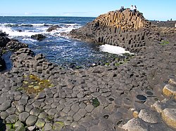 | County Antrim, Northern Ireland | Collection of 40,000 regular polygonal basalt columns formed by rapidly cooling lava. Also a UNESCO World Heritage Site | [1] |
| Jurassic Coast |  | Devon & Dorset, England | 95-mile (153 km) long stretch of coast containing fossils from the Mesozoic era. Also a UNESCO World Heritage Site | [1] |
| Loch Coruisk & The Cuillins |  | Isle of Skye, Scotland | Freshwater loch in the centre of the island, surrounded by the Black Cuillins mountains. | [1] |
| Pistyll Rhaeadr |  | Powys, Wales | 240-foot (73 m) tall waterfall, one of Britain's tallest, fed by streams from the Berwyn Mountains | [1] |
| The Needles |  | Isle of Wight, England | A series of chalk stacks extending into the sea from the western end of the island | [1] |
| Wastwater |  | Lake District, England | Glacial valley surrounded by some of the Lake District's tallest mountains | [1] |