
The Highlands is a historical region of Scotland. Culturally, the Highlands and the Lowlands diverged from the Late Middle Ages into the modern period, when Lowland Scots language replaced Scottish Gaelic throughout most of the Lowlands. The term is also used for the area north and west of the Highland Boundary Fault, although the exact boundaries are not clearly defined, particularly to the east. The Great Glen divides the Grampian Mountains to the southeast from the Northwest Highlands. The Scottish Gaelic name of A' Ghàidhealtachd literally means "the place of the Gaels" and traditionally, from a Gaelic-speaking point of view, includes both the Western Isles and the Highlands.

The West Highland Way is a linear long-distance route in Scotland. It is 154 km long, running from Milngavie north of Glasgow to Fort William in the Scottish Highlands, with an element of hill walking in the route. The trail, which opened in 1980, was Scotland's first officially designated Long Distance Route, and is now designated by NatureScot as one of Scotland's Great Trails. It is primarily intended as a long distance walking route, and whilst many sections are suitable for mountain biking and horseriding there are obstacles and surfaces that will require these users to dismount in places.

The Cuillin is a range of mostly jagged rocky mountains on the Isle of Skye in Scotland. The main Cuillin ridge is also called the Black Cuillin to distinguish it from the Red Cuillin, which lie to the east of Glen Sligachan.

Sgùrr Dearg is a mountain in the Cuillin on the Isle of Skye, Scotland. It is topped by the Inaccessible Pinnacle, a fin of rock measuring 50 metres (160 ft) along its longest edge. The top of the Pinnacle stands at 985.8 m (3,234 ft) above sea level, making Sgùrr Dearg the only Munro with a peak that can only be reached by rock climbing. This makes it the biggest hurdle for many Munro baggers.

Loch Shiel is a freshwater loch situated 20 kilometres (12 mi) west of Fort William in the Highland council area of Scotland. At 28 kilometres long it is the 4th longest loch in Scotland, and is the longest to have retained a natural outflow without any regulation of its water level, being 120 m (393 ft) deep. Its nature changes considerably along its length, being deep and enclosed by mountains in the north east and shallow surrounded by bog and rough pasture in the south west, from which end the 4 km River Shiel drains to the sea in Loch Moidart near Castle Tioram.

Am Basteir is a mountain peak in the northern Cuillin range on the Isle of Skye in Scotland. It is 934 metres high and classed as a Munro. It forms a narrow blade of rock, which bears comparison with the Inaccessible Pinnacle in the same range.

Port an Eòrna is the Scottish Gaelic name for the small settlement of Barleyport, situated almost midway between Plockton and the Kyle of Lochalsh, in Ross-shire, Scotland, in the Western Highlands. Port an Eòrna was once a fishing community near Duirinish, an area of common grazing for sheep and Highland cattle. Now it is a cluster of a few houses on National Trust for Scotland land. Port an Eòrna is a natural sandy beach. Eòrna means "barley" in Scottish Gaelic.

Maol Cheann-Dearg is a mountain in the Northwest Highlands of Scotland, between Upper Loch Torridon and Loch Carron, in the Coulags deer forest in Wester Ross. It is one of three Munros in this area and reaches a height of 933 metres (3,060 feet), it is slightly isolated from the other two being separated by a low col of 420 metres and therefore tends to be ascended separately. The mountain is typical of the region in that geologically it is made up of a mixture of sandstone and quartzite, it has a steep flanks and is rock-strewn. The dome shaped summit is littered with red sandstone boulders and lacking in vegetation making its translated name of "red-headed brow" especially appropriate. The mountain is not to be confused with Maol Chinn-dearg, another Munro on the south Glen Shiel ridge.

Glenmoriston or Glen Moriston is a river glen in the Scottish Highlands, that runs from Loch Ness, at the village of Invermoriston, westwards to Loch Cluanie, where it meets with Glen Shiel. The A887 and A87 roads pass through Glenmoriston.
Heasta, Heast, or the anglicised form Heaste, pron. /heɪst/, is a small settlement on the island of Skye, Scotland. It is located on the west coast of the island five miles south of Broadford extending down to the north shore of Loch Eiseort, facing out to the Atlantic to the south west and is in the Scottish council area of Highland.
"The Road to the Isles" is a famous tune composed by Pipe Major John McLellan DCM which was originally called "The Bens of Jura", although it previously had other titles. It is part of the Kennedy-Fraser collection, and it appeared in a book entitled Songs of the Hebrides, published in 1917, with the eponymous title by the Celtic poet Kenneth Macleod. The poem is headed by the statement "Written for the lads in France during the Great War." The impression is given by the notes appended to the book that the author was Kenneth Macleod himself. Marjory Kennedy-Fraser toured the Western Isles of Scotland in the summer of 1917 and collected a group of local tunes. The tune associated with the "Road to the Isles" was an air played by Malcolm Johnson of Barra, on a chanter, and composed by Pipe Major John McLellan of Dunoon. Macleod then wrote the words for a voice and harp arrangement of this air by Patuffa Kennedy-Fraser.
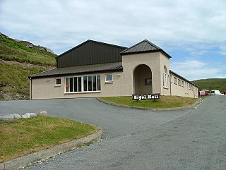
Elgol is a village on the shores of Loch Scavaig towards the end of the Strathaird peninsula in the Isle of Skye, in the Scottish Highlands.

The Isle of Skye, or simply Skye, is the largest and northernmost of the major islands in the Inner Hebrides of Scotland. The island's peninsulas radiate from a mountainous hub dominated by the Cuillin, the rocky slopes of which provide some of the most dramatic mountain scenery in the country. Although Sgitheanach has been suggested to describe a winged shape, no definitive agreement exists as to the name's origins.

Inverness-shire or the County of Inverness, is a historic county in Scotland. It is named after Inverness, its largest settlement, which was also the county town. Covering much of the Highlands and some of the Hebrides, it is Scotland's largest county by land area. It is generally rural and sparsely populated, containing only three towns which held burgh status, being Inverness, Fort William and Kingussie. The county is crossed by the Great Glen, which contains Loch Ness and separates the Grampian Mountains to the south-east from the Northwest Highlands. The county also includes Ben Nevis, the highest mountain in both Scotland and the United Kingdom.

Minginish is a peninsula on the Isle of Skye in Scotland. It is situated on the west coast of the island and runs from Loch Scavaig in the south, along the western coast of Skye to Loch Bracadale in the north west, to Loch Harport in the north east, and Glen Sligachan in the south east. It includes most of the peaks of the Cuillin hills including Sgurr Alasdair, the highest point on the island at 992 metres (3,255 ft). The island of Soay lies offshore across the Soay Sound, with the Small Isles further south across the Cuillin Sound.
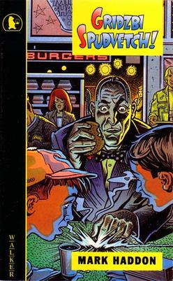
Boom! is a 2008 children's science fiction novel by English writer and illustrator Mark Haddon. It is the revised version of Haddon's Gridzbi Spudvetch!, published in 1993.

The Scavaig River or River Coruisk is a river on the Isle of Skye, in Scotland. It is located amongst the Cuillin, and flows from Loch Coruisk to meet the sea at Loch na Cuilce, an inlet of Loch Scavaig.

The Great Trossachs Path is a 48-kilometre (30 mi) long-distance footpath through the Trossachs, in the Stirling council area of Scotland. It runs between Callander in the east and Inversnaid on the banks of Loch Lomond in the west, passing along the northern shores of Loch Katrine and Loch Arklet. The path is suitable for walkers and cyclists; much of the route is also suitable for experience horse riders, although the middle section along the shoreline of Loch Katrine is tarmacked and so may not be ideal for horses.

Sgùrr Dubh Mòr is a 944-metre (3,097 ft) mountain, a Munro, in the Cuillin range on the Isle of Skye in Scotland. It is slightly to the east of the main Cuillin ridge at the highest point of the Dubh ridge which extends eastwards to Loch Coruisk.

Sgùrr nan Eag is a mountain 924 metres (3,031 ft) high in the Cuillin range on the Isle of Skye, Scotland. It is the southernmost Munro of the Cuillins and it lies between Coir' a' Ghrunnda to the west, Gars-bheinn to the east, and Garb-choire to the north.


