
A thunderstorm, also known as an electrical storm or a lightning storm, is a storm characterized by the presence of lightning and its acoustic effect on the Earth's atmosphere, known as thunder. Relatively weak thunderstorms are sometimes called thundershowers. Thunderstorms occur in a type of cloud known as a cumulonimbus. They are usually accompanied by strong winds and often produce heavy rain and sometimes snow, sleet, or hail, but some thunderstorms produce little precipitation or no precipitation at all. Thunderstorms may line up in a series or become a rainband, known as a squall line. Strong or severe thunderstorms include some of the most dangerous weather phenomena, including large hail, strong winds, and tornadoes. Some of the most persistent severe thunderstorms, known as supercells, rotate as do cyclones. While most thunderstorms move with the mean wind flow through the layer of the troposphere that they occupy, vertical wind shear sometimes causes a deviation in their course at a right angle to the wind shear direction.

A mesocyclone is a meso-gamma mesoscale region of rotation (vortex), typically around 2 to 6 mi in diameter, most often noticed on radar within thunderstorms. In the northern hemisphere it is usually located in the right rear flank of a supercell, or often on the eastern, or leading, flank of a high-precipitation variety of supercell. The area overlaid by a mesocyclone’s circulation may be several miles (km) wide, but substantially larger than any tornado that may develop within it, and it is within mesocyclones that intense tornadoes form.

A squall is a sudden, sharp increase in wind speed lasting minutes, as opposed to a wind gust, which lasts for only seconds. They are usually associated with active weather, such as rain showers, thunderstorms, or heavy snow. Squalls refer to the increase of the sustained winds over that time interval, as there may be higher gusts during a squall event. They usually occur in a region of strong sinking air or cooling in the mid-atmosphere. These force strong localized upward motions at the leading edge of the region of cooling, which then enhances local downward motions just in its wake.

A squall line, or more accurately a quasi-linear convective system (QLCS), is a line of thunderstorms, often forming along or ahead of a cold front. In the early 20th century, the term was used as a synonym for cold front. Linear thunderstorm structures often contain heavy precipitation, hail, frequent lightning, strong straight-line winds, and occasionally tornadoes or waterspouts. Particularly strong straight-line winds can occur where the linear structure forms into the shape of a bow echo. Tornadoes can occur along waves within a line echo wave pattern (LEWP), where mesoscale low-pressure areas are present. Some bow echoes can grow to become derechos as they move swiftly across a large area. On the back edge of the rainband associated with mature squall lines, a wake low can be present, on very rare occasions associated with a heat burst.

The Storm Prediction Center (SPC) is a US government agency that is part of the National Centers for Environmental Prediction (NCEP), operating under the control of the National Weather Service (NWS), which in turn is part of the National Oceanic and Atmospheric Administration (NOAA) of the United States Department of Commerce (DoC).

A derecho is a widespread, long-lived, straight-line wind storm that is associated with a fast-moving group of severe thunderstorms known as a mesoscale convective system.
This is a list of meteorology topics. The terms relate to meteorology, the interdisciplinary scientific study of the atmosphere that focuses on weather processes and forecasting.
This article describes severe weather terminology used by the National Weather Service (NWS) in the United States, a government agency operating within the Department of Commerce as an arm of the National Oceanic and Atmospheric Administration (NOAA).

A mesoscale convective system (MCS) is a complex of thunderstorms that becomes organized on a scale larger than the individual thunderstorms but smaller than extratropical cyclones, and normally persists for several hours or more. A mesoscale convective system's overall cloud and precipitation pattern may be round or linear in shape, and include weather systems such as tropical cyclones, squall lines, lake-effect snow events, polar lows, and mesoscale convective complexes (MCCs), and generally forms near weather fronts. The type that forms during the warm season over land has been noted across North and South America, Europe, and Asia, with a maximum in activity noted during the late afternoon and evening hours.

A mesoscale convective complex (MCC) is a unique kind of mesoscale convective system which is defined by characteristics observed in infrared satellite imagery. They are long-lived, often form nocturnally, and commonly contain heavy rainfall, wind, hail, lightning, and possibly tornadoes.
A bow echo is the characteristic radar return from a mesoscale convective system that is shaped like an archer's bow. These systems can produce severe straight-line winds and occasionally tornadoes, causing major damage. They can also become derechos or form Line echo wave pattern (LEWP).

Severe weather is any dangerous meteorological phenomenon with the potential to cause damage, serious social disruption, or loss of human life. These vary depending on the latitude, altitude, topography, and atmospheric conditions. High winds, hail, excessive precipitation, and wildfires are forms and effects, as are thunderstorms, downbursts, tornadoes, waterspouts, tropical cyclones, and extratropical cyclones. Regional and seasonal phenomena include blizzards (snowstorms), ice storms, and duststorms.

The May 2009 Southern Midwest Derecho was an extreme progressive derecho and mesoscale convective vortex (MCV) event that struck southeastern Kansas, southern Missouri, and southwestern Illinois on May 8, 2009. Thirty-nine tornadoes, including two of EF3 strength on the Enhanced Fujita Scale, were reported in addition to high non-tornadic winds associated with the derecho and MCV. Due to the abnormal shape of the storm on radar and the extremely strong winds, many called this an "inland hurricane." A new class of storm, the Super Derecho, has been used to describe this event after analysis in 2010. Embedded supercells produced hail up to baseball size in southern Missouri, a rare event in a derecho. A wind gust of 106 mph (171 km/h) was recorded by a backup anemometer at the Southern Illinois Airport after official National Weather Service equipment failed. This derecho was the last of a series of derechos that occurred at the beginning of May.

From May 3 to May 11, 2003, a prolonged and destructive series of tornado outbreaks affected much of the Great Plains and Eastern United States. Most of the severe activity was concentrated between May 4 and May 10, which saw more tornadoes than any other week-long span in recorded history; 335 tornadoes occurred during this period, concentrated in the Ozarks and central Mississippi River Valley. Additional tornadoes were produced by the same storm systems from May 3 to May 11, producing 363 tornadoes overall, of which 62 were significant. Six of the tornadoes were rated F4, and of these four occurred on May 4, the most prolific day of the tornado outbreak sequence; these were the outbreak's strongest tornadoes. Damage caused by the severe weather and associated flooding amounted to US$4.1 billion, making it the costliest U.S. tornado outbreak of the 2000s. A total of 50 deaths and 713 injuries were caused by the severe weather, with a majority caused by tornadoes; the deadliest tornado was an F4 that struck Madison and Henderson counties in Tennessee, killing 11. In 2023, tornado expert Thomas P. Grazulis created the outbreak intensity score (OIS) as a way to rank various tornado outbreaks. The tornado outbreak sequence of May 2003 received an OIS of 232, making it the fourth worst tornado outbreak in recorded history.
A mesovortex is a small-scale rotational feature found in a convective storm, such as a quasi-linear convective system, a supercell, or the eyewall of a tropical cyclone. Mesovortices range in diameter from tens of miles to a mile or less and can be immensely intense.

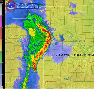
A line echo wave pattern (LEWP) is a weather radar formation in which a single line of thunderstorms presenting multiple bow echoes forms south of a mesoscale low-pressure area with a rotating "head". LEWP often are associated with a multiple-bow serial derecho and often produce tornadoes, some of which can be strong. The existence of a LEWP on radar means that a serial derecho has developed or is likely to develop soon, much as a hook echo indicates the same for a tornado.

A significant and destructive tornado outbreak that affected parts of the Midwestern United States and lower Great Plains in mid-May 2013. This event occurred just days after a deadly outbreak struck Texas and surrounding southern states on May 15. On May 16, a slow moving trough crossed the Rockies and traversed the western Great Plains. Initially, activity was limited to scattered severe storms; however, by May 18, the threat for organized severe thunderstorms and tornadoes greatly increased. A few tornadoes touched down that day in Kansas and Nebraska, including an EF4 tornado near Rozel, Kansas. Maintaining its slow eastward movement, the system produced another round of severe weather nearby. Activity significantly increased on May 19, with tornadoes confirmed in Oklahoma, Kansas, Iowa, Missouri, and Illinois. In Oklahoma, two strong tornadoes, one rated EF4, caused significant damage in rural areas of the eastern Oklahoma City metropolitan area; two people lost their lives near Shawnee. The most dramatic events unfolded on May 20 as a large EF5 tornado devastated parts of Moore, Oklahoma, killing 24 people. Thousands of structures were destroyed, with many being completely flattened. Several other tornadoes occurred during the day in areas further eastward, though the majority were weak and caused little damage.
The following is a glossary of tornado terms. It includes scientific as well as selected informal terminology.

Starting on the evening of July 13 and extending through July 16, 2024, an intense sequence of severe weather outbreaks affected much of the Midwestern and Northeastern United States. This included two significant derechoes that each had wind gusts exceeding 100 mph (160 km/h), as well as multiple tornado outbreaks that produced a combined 90 tornadoes across the affected areas. A ring of fire pattern fueled multiple systems that brought heavy rain and a tornado outbreak to northern Illinois, contributing to a partial dam failure in Washington County, Illinois, and multiple events of 90 mph (140 km/h) wind gusts. The sequence as a whole killed five people and injured three more.