
The River Severn, at 220 miles (354 km) long, is the longest river in Great Britain. It is also the river with the most voluminous flow of water by far in all of England and Wales, with an average flow rate of 107 m3/s (3,800 cu ft/s) at Apperley, Gloucestershire. It rises in the Cambrian Mountains in mid Wales, at an altitude of 2,001 feet (610 m), on the Plynlimon massif, which lies close to the Ceredigion/Powys border near Llanidloes. The river then flows through Shropshire, Worcestershire and Gloucestershire. The county towns of Shrewsbury, Gloucester and the City of Worcester lie on its course.

The Humber is a large tidal estuary on the east coast of Northern England. It is formed at Trent Falls, Faxfleet, by the confluence of the tidal rivers Ouse and Trent. From there to the North Sea, it forms part of the boundary between the East Riding of Yorkshire on the north bank and North Lincolnshire on the south bank. Although the Humber is an estuary from the point at which it is formed, many maps show it as the River Humber.

Water transport played a vital role in the UK's industrial development. The beginning of the 19th century saw a move from roads to waterways,.
Read's Island is an island situated just outside the Ancholme sluice, on the Humber Estuary in England. The Lincolnshire Trust suggest it is an artificial island, and a report from 1979 says that it was reclaimed. However, the site was for many years a large sandbank going by the name of "Old Warp" and is shown on the 1734 Customs Map of the Humber where Read's Island now lays, and extending further downstream.

The canvasback is a species of diving duck, the largest found in North America.

The ring-necked duck is a diving duck from North America commonly found in freshwater ponds and lakes. The scientific name is derived from Greek aithuia, an unidentified seabird mentioned by authors including Hesychius and Aristotle, and Latin collaris, "of the neck" from collum, "neck".

The common pochard is a medium-sized diving duck. The scientific name is derived from Greek aithuia an unidentified seabird mentioned by authors including Hesychius and Aristotle, and Latin ferina, "wild game", from ferus, "wild".

The greater scaup, just scaup in Europe or, colloquially, "bluebill" in North America, is a mid-sized diving duck, larger than the closely related lesser scaup. It spends the summer months breeding in Alaska, northern Canada, Siberia, and the northernmost reaches of Europe. During the winter, it migrates south to the coasts of North America, Europe, and Japan.

The spotted redshank is a wader (shorebird) in the large bird family Scolopacidae. The genus name Tringa is the New Latin name given to the green sandpiper by Aldrovandus in 1599 based on Ancient Greek trungas, a thrush-sized, white-rumped, tail-bobbing wading bird mentioned by Aristotle. The specific erythropus is from Ancient Greek eruthros, "red", and pous, "foot".

The River Tame is a river in the West Midlands of England, and one of the principal tributaries of the River Trent. The Tame is about 95 km (59 mi) long from the source at Oldbury to its confluence with the Trent near Alrewas, but the main river length of the entire catchment, i.e. the Tame and its main tributaries, is about 285 km (177 mi).

Blacktoft Sands RSPB reserve is a nature reserve in the East Riding of Yorkshire, England. It is managed by the Royal Society for the Protection of Birds, which leases the site from Associated British Ports.
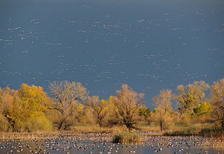
A flyway is a flight path used by large numbers of birds while migrating between their breeding grounds and their overwintering quarters. Flyways generally span continents and often pass over oceans. Although applying to any species of migrating bird, the concept was first conceived and applied to waterfowl and shore birds. The flyways can be thought of as wide arterial highways to which the migratory routes of different species are tributaries. An alternative definition is that a flyway is the entire range of a migratory bird, encompassing both its breeding and non-breeding grounds, and the resting and feeding locations it uses while migrating. There are four major north–south flyways in North America and six covering Eurasia, Africa, and Australasia.

The Severn Estuary is the estuary of the River Severn, flowing into the Bristol Channel between South West England and South Wales. Its high tidal range, approximately 50 feet (15 m), means that it has been at the centre of discussions in the UK regarding renewable energy.

The Dee Estuary is a large estuary by means of which the River Dee flows into Liverpool Bay. The estuary starts near Shotton after a five-mile (8 km) 'canalised' section and the river soon swells to be several miles wide forming the boundary between the Wirral Peninsula in north-west England and Flintshire in north-east Wales. The Dee Estuary's largest towns along it include Hollywell, Flint, Connah's Quay, Shotton, Queensferry, Saltney Ferry, Chester (City), Heswall, West Kirby and Neston as well as other villages and towns alongside it. The A548 also passes along the estuary in Wales and parts of Cheshire West and Chester and Merseyside in England. The North Wales Coast Line follows the course of the Dee Estuary between Prestatyn and Chester.

Trent Falls is the confluence of the River Ouse and the River Trent which forms the Humber between Lincolnshire and the East Riding of Yorkshire in England.

Lloegyr is the medieval Welsh name for a region of Britain (Prydain). The exact borders are unknown, but some modern scholars hypothesize it ran south and east of a line extending from the Humber Estuary to the Severn Estuary, exclusive of Cornwall and Devon. The people of Lloegyr were called Lloegyrwys without distinction of ethnicity, the term applying to both Britons and Anglo-Saxons.

In Yorkshire there is a very close relationship between the major topographical areas and the geological period in which they were formed. The Pennine chain of Hills in the west is of Carboniferous origin. The central vale is Permo-Triassic. The North York Moors in the north-east of the county are Jurassic in age while the Yorkshire Wolds to the south east are Cretaceous chalk uplands. The plain of Holderness and the Humberhead levels both owe their present form to the Quaternary ice ages.

This is a list of the longest rivers of the United Kingdom.

Howden Dyke Island is a 19-acre (7.7 ha) island in the River Ouse, Yorkshire. More accurately a shoal between seasonally varying flows, the area regularly above water is roughly 1,380 by 890 feet. A larger example of this same feature is visible where the Ouse widens into the Humber Estuary, 12 miles (19 km) downstream at Faxfleet.

Whitton Island is an island situated at the western end of the Humber Estuary in northern England.


