The Red Rock Canyon National Conservation Area in Nevada is an area managed by the Bureau of Land Management as part of its National Landscape Conservation System, and protected as a National Conservation Area. It is about 15 miles (24 km) west of Las Vegas, and is easily seen from the Las Vegas Strip. More than two million people visit the area each year.

The Continental Divide National Scenic Trail is a United States National Scenic Trail running 3,100 miles (5,000 km) between Mexico and Canada. It follows the Continental Divide of the Americas along the Rocky Mountains and traverses five U.S. states — Montana, Idaho, Wyoming, Colorado, and New Mexico. In Montana it crosses Triple Divide Pass The trail is a combination of dedicated trails and small roads and considered 70% complete. Portions designated as uncompleted must be traveled by roadwalking on dirt or paved roads. This trail can be continued north into Canada to Kakwa Lake north of Jasper National Park by the Great Divide Trail.

Crowders Mountain State Park is a 5,126-acre (20.74 km2) North Carolina state park in Gaston County, North Carolina in the United States. It is near Kings Mountain, North Carolina and on the outskirts of Gastonia, North Carolina, it includes the peaks of Crowder's Mountain and The Pinnacle. Crowders Mountain was named for Crowders Creek which originated near its base. Contrary to some historical information, Crowders Mountain was not named for Ulrick Crowder. There is no historical evidence that he was ever in the immediate area. The cliffs are a popular destination for rock climbers.

The American Discovery Trail is a system of recreational trails and roads which collectively form a coast-to-coast hiking and biking trail across the mid-tier of the United States. Horses can also be ridden on most of this trail. It starts on the Delmarva Peninsula on the Atlantic Ocean and ends on the northern California coast on the Pacific Ocean. The trail has northern and southern alternates for part of its distance, passing through Chicago and St Louis respectively. The total length of the trail including both the north and south routes is 6,800 miles (10,900 km). The northern route covers 4,834 miles (7,780 km) with the southern route covering 5,057 miles (8,138 km). It is the only non-motorized coast-to-coast trail.

Mount Charleston, officially named Charleston Peak, at 11,916 feet (3,632 m), is the highest mountain in both the Spring Mountains and Clark County, in Nevada, United States. It is the eighth-highest mountain in the state. Well separated from higher peaks by large, low basins, it is the most topographically prominent peak in Nevada, and the eighth-most-prominent peak in the contiguous United States. It is one of eight ultra-prominent peaks in Nevada. It is located about 35 miles (56 km) northwest of Las Vegas within the Mount Charleston Wilderness, which is within the Spring Mountains National Recreation Area of the Humboldt-Toiyabe National Forest.

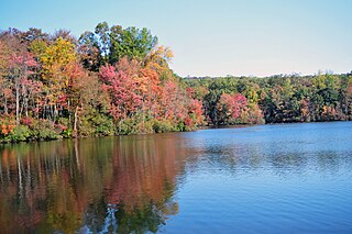
At 47,527 acres (192.33 km2), Harriman State Park is the second largest state park in New York State. Located in Rockland and Orange counties 30 miles (48 km) north of New York City, it is a haven for hikers with over 200 miles (320 km) of hiking trails. The park is also known for its 31 lakes, multiple streams, public camping area, and great vistas. The park's hiking trails are currently maintained by volunteers from the New York - New Jersey Trail Conference.

The Long Path is a 357-mile (575 km) long-distance hiking trail beginning at the George Washington Bridge in Fort Lee, New Jersey and ending at Altamont, New York, in the Albany area. While not yet a continuous trail, relying on road walks in some areas, it nevertheless takes in many of the popular hiking attractions west of the Hudson River, such as the New Jersey Palisades, Harriman State Park, the Shawangunk Ridge and the Catskill Mountains. It offers hikers a diversity of environments to pass through, from suburbia and sea-level salt marshes along the Hudson to wilderness and boreal forest on Catskill summits 4,000 feet (1,220 m) in elevation.

The Grand Island National Recreation Area is a National Recreation Area within the jurisdiction of the U.S. Forest Service. It is part of the Hiawatha National Forest. Located on Grand Island, Michigan offshore from Munising, Michigan, the Grand Island National Recreation Area covers approximately 13,500 acres (55 km2) of Lake Superior woodland. Grand Island's glacier-cut lake shoreline measures approximately 35 miles (56 km) in length. The island's maximum dimension is 8 miles (13 km) from north to south. Grand Island was elevated to the status of a National Recreation Area by the U.S. Congress in 1990 after the U.S. Forest Service purchased the island from its former owner, Cleveland Cliffs Iron Co.
This is a list of trails in Ithaca, New York.

Humboldt Peak is a high mountain summit of the Crestones in the Sangre de Cristo Range of the Rocky Mountains of North America. The 14,070-foot (4,289 m) fourteener is located in the Sangre de Cristo Wilderness of San Isabel National Forest, 11.9 miles (19.2 km) south-southwest of the Town of Westcliffe in Custer County, Colorado, United States. The Crestones are a cluster of high summits in the Sangre de Cristo Range, comprising Crestone Peak, Crestone Needle, Kit Carson Peak, Challenger Point, Humboldt Peak, and Columbia Point.

Two Medicine is the collective name of a region located in the southeastern section of Glacier National Park, in the U.S. state of Montana. It has a campground alongside Two Medicine Lake. From the period starting in the late 1890s until the completion of the Going-to-the-Sun Road in 1932, Two Medicine was one of the most visited sections of the park. Once part of a larger chalet complex, the Two Medicine Store is located along the shores of Two Medicine Lake and the building is a National Historic Landmark. The region is a starting point for many trails and tourboats take visitors out on Two Medicine Lake, where the steep south face of Rising Wolf Mountain towers above the lake. The region was considered sacred ground by several Native American tribes including the Blackfeet and they performed Vision quests here. Aside from Chief Mountain, the Two Medicine area is the most sacred section of the park to the Blackfeet.
French Creek State Park is a 7,526-acre (3,046 ha) Pennsylvania state park in North Coventry and Warwick Townships in Chester County and Robeson and Union Townships in Berks County, Pennsylvania in the United States. It straddles northern Chester County and southern Berks County along French Creek. It is located in the Hopewell Big Woods. The park is the home of two lakes: Hopewell Lake, a 68-acre (28 ha) warm water lake, and Scotts Run Lake, a 22-acre (8.9 ha) cold water lake. The state record smallmouth bass was caught in Scotts Run Lake. There are extensive forests, and almost 40 miles (64 km) of hiking and equestrian trails. The park is also friendly to mountain bikers, having some renowned technical trails. Hopewell Furnace National Historic Site, which features a cold blast furnace restored to its 1830s appearance, is surrounded by the park. The Six Penny Day Use Area and Group Camp are listed on the National Register of Historic Places. French Creek State Park is located off of Pennsylvania Route 345 to the south of Birdsboro.
The Appalachian National Scenic Trail spans fourteen U.S. states during its roughly 2,200 miles (3,500 km)-long journey: Georgia, North Carolina, Tennessee, Virginia, West Virginia, Maryland, Pennsylvania, New Jersey, New York, Connecticut, Massachusetts, Vermont, New Hampshire, and Maine. It begins at Springer Mountain, Georgia, and follows the ridgeline of the Appalachian Mountains, crossing many of its highest peaks and running with only a few exceptions almost continuously through wilderness before ending at Mount Katahdin, Maine.
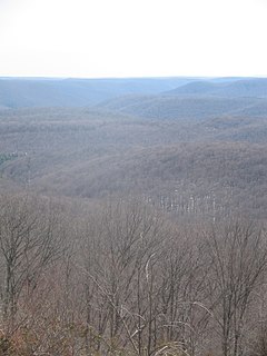
Clearwater Wilderness, a small 14,300-acre (5,800 ha) wilderness area in the North Cascades mountain range, in northern Washington state, of the Northwestern United States. It is located in the Mount Baker-Snoqualmie National Forest, and southeast of Tacoma in northeastern Pierce County.

The Palmetto Trail is a planned 425-mile-long (684 km) foot and mountain bike trail in South Carolina for recreational hiking and biking. Several of the sections are also equestrian trails. It will extend from the Oconee County mountains to the Intracoastal Waterway in Charleston County. It currently consists of 23 segments totaling 235 miles (378 km). Maps and trail guides are available.
The Susquehannock Trail System is an 85-mile (137 km) loop hiking trail in the Susquehannock State Forest in Potter and Clinton counties in north-central Pennsylvania in the United States. The trail goes through three state parks and passes within 2 miles (3 km) of three more state parks. Other highlights include a fire tower, vistas, and the Hammersley Wild Area, the largest area in Pennsylvania without a road. The STS was founded by William Fish Jr. in 1966 and is maintained by the Susquehannock Trail Club in cooperation with the Pennsylvania Department of Conservation and Natural Resources (DCNR). In the south it shares 8.7 miles (14.0 km) of its course in Clinton County with the 90-mile (140 km) Donut Hole Trail. The STS also connects to the east with the Black Forest Trail in Lycoming County via two short link trails.

Doughton Park is the largest recreation area the National Park Service manages on the Blue Ridge Parkway. It is located between mile markers 238.5 - 244.7 and at 36° 30' 59.0394" N, -81° 8' 40.92" W. The park is named after North Carolina politician Robert L. Doughton.

Farlow Gap is a popular trail for mountain biking and hiking, located in the western area of North Carolina. It is an expert-level trail, and considered "one of the toughest mountain bike trails in Pisgah National Forest." It is primarily a downhill trail, about 3.1 miles (5.0 km) in length. It can be combined with other trails to form a loop of about 14 miles (23 km), requiring anywhere from three to six hours to complete.