
100 Mile House is a district municipality located in the South Cariboo region of central British Columbia, Canada.

Canada has a large domestic and foreign tourism industry. The second largest country in the world, Canada's incredible geographical variety is a significant tourist attractor. Much of the country's tourism is centred in the following regions: Toronto, Montreal, Quebec City, Vancouver/Whistler, Niagara Falls, Vancouver Island, Canadian Rockies, British Columbia's Okanagan Valley, Churchill, Manitoba and the National Capital Region of Ottawa-Gatineau. The large cities are known for their culture, diversity, as well as the many national parks and historic sites.

Salmon Arm is a city in the Columbia Shuswap Regional District of the Southern Interior of the Canadian province of British Columbia that has a population of 17,706 (2016). Salmon Arm was incorporated as a municipal district on May 15, 1905. The city of Salmon Arm separated from the district in 1912, but was downgraded to a village in 1958. In 1970, the city of Salmon Arm once again reunited with the District Municipality. Salmon Arm once again became a city in 2005, and is now the location of the head offices of the Columbia-Shuswap Regional District. It is a tourist town in the summer, with many beaches, camping facilities and house boat rentals. Salmon Arm is home to the longest wooden freshwater wharf in North America.

Burns Lake is a rural village in the North-western-Central Interior of British Columbia, Canada, incorporated in 1923. The village had a population of 1,659 as of the 2021 Census.

Klondike Gold Rush National Historical Park is a national historical park operated by the National Park Service that seeks to commemorate the Klondike Gold Rush of the late 1890s. Though the gold fields that were the ultimate goal of the stampeders lay in the Yukon Territory, the park comprises staging areas for the trek there and the routes leading in its direction. There are four units, including three in Municipality of Skagway Borough, Alaska and a fourth in the Pioneer Square National Historic District in Seattle, Washington.

Barrhead is a town in central Alberta, Canada that is surrounded by the County of Barrhead No. 11. It is located along the Paddle River and at the intersection of Highway 33 and Highway 18, approximately 120 km (75 mi) northwest of the City of Edmonton. It is also located along the route of the Express Trail, used by the North West Company, which was originally a First Nations trail. The trail was later widened by George Simpson and John Rowand to save the North West Company over $5,000.

Fort Qu'Appelle is a town in Canadian province of Saskatchewan located in the Qu'Appelle River valley 70 km (43 mi) north-east of Regina, between Echo and Mission Lakes of the Fishing Lakes. It is not to be confused with the once-significant nearby town of Qu'Appelle. It was originally established in 1864 as a Hudson's Bay Company trading post. Fort Qu'Appelle, with its 1,919 residents in 2006, is at the junction of Highway 35, Highway 10, Highway 22, Highway 56, and Highway 215. The 1897 Hudson's Bay Company store, 1911 Grand Trunk Pacific Railway station, Fort Qu'Appelle Sanatorium, and the Treaty 4 Governance Centre in the shape of a teepee are all landmarks of this community. Additionally, the Noel Pinay sculpture of a man praying commemorates a burial ground, is a life-sized statue in a park beside Segwun Avenue.

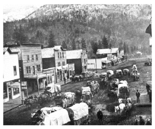
Williams Lake is a city in the Central Interior of British Columbia, in the central part of a region known as the Cariboo. Williams Lake is the one of the largest cites, by population of metropolitan area, in the Cariboo after neighbouring Quesnel. The city is famous for the Williams Lake Stampede, which was once the second largest professional rodeo in Canada, after only the Calgary Stampede.
British Columbia gold rushes were important episodes in the history and settlement of European, Canadian and Chinese peoples in western Canada.
Dease Lake is a small community in the Cassiar Country of the Northern Interior of British Columbia, Canada. It is 230 km south of the Yukon border on Stewart–Cassiar Highway at the south end of the lake of the same name. Dease Lake is the last major centre before the Alaska Highway while driving northbound, and also the junction to Telegraph Creek and the Grand Canyon of the Stikine. Dease Lake Indian Reserve No. 9 is nearby and is under the governance of the Tahltan First Nation band government.

Stave Lake is a lake and reservoir for the production of hydroelectricity in the Stave River system, located on the northern edge of the District of Mission, about 65 km (40 mi) east of Vancouver, British Columbia, Canada. The main arm of the lake is about 20 km (12 mi) long from north to south and its southwest arm, ending at Stave Falls Dam near Stave Falls, is about 9.5 km (5.9 mi) long. The total area of the lake currently is about 55 square kilometres. Prior to construction of the dam, the lake was about one-third the size of its current main arm.

Shawnigan Lake is the name of a village on British Columbia's Vancouver Island. The name Shawnigan is an adaptation of the Hul'qumi'num name Showe'luqun, for the lake and the village. It is part of Electoral Area B in the Cowichan Valley Regional District. As of 2016, the permanent population of Shawnigan Lake is 8,558.

Atlin is a community in northwestern British Columbia, Canada, located on the eastern shore of Atlin Lake. In addition to continued gold-mining activity, Atlin is a tourist destination for fishing, hiking and heliskiing. As of 2016, there are 477 permanent residents.
Upper Seymour River Provincial Park is a provincial park in British Columbia, Canada. Located in an isolated area in the interior of the province, 40 kilometres north of the community of Seymour Arm. It protects at the headwaters of the Seymour River, which is the major drainage system into the Seymour Arm of Shuswap Lake.

Likely is an unincorporated community in British Columbia, Canada. It is located in the Cariboo region of the province, and is situated where the west arm of Quesnel Lake empties into the Quesnel River. Roads from Likely lead southwest to Williams Lake, northwest to Quesnel, south to Horsefly, and north to Barkerville. Likely is in the Quesnel Highland, a transition zone between the Cariboo Plateau and the Cariboo Mountains.

Tulameen, originally known as Otter Flat, is a small community in British Columbia, Canada, about 26 kilometres northwest of the town of Princeton on the Crowsnest Highway, and about 185 kilometres northeast from the city of Vancouver, British Columbia. Located at the south end of Otter Lake and just north of the Tulameen River, it is on the lee side of the Canadian Cascades mountain range and enjoys a slightly semi-arid climate, sheltered from the heavy rains west of that range.
The Big Bend Gold Rush was a gold rush in the Big Bend Country of the Colony of British Columbia in the mid-1860s.
Babb is a small unincorporated farming and ranching community in Glacier County, Montana, United States, on the Blackfeet Indian Reservation. The community experiences a large influx of tourists in the summer months as it is the gateway to the Many Glacier area of Glacier National Park. For statistical purposes, the United States Census Bureau has defined Babb as a census-designated place (CDP). It had a population of 174 at the 2010 census.
Cascade City or Cascade was a Canadian Pacific Railway construction era boom town in the Boundary Country of the West Kootenay region of British Columbia, Canada. Because of its location near the Canada–United States border, it was also called the "Gateway to the Boundary Country".
The Nechako Region is the second-largest economic development region in British Columbia and covers an area of 200,023 km2, from the Nechako plateau, in central British Columbia, northward to the border with Yukon Territory.
