
Pyroclastic rocks are clastic rocks composed of rock fragments produced and ejected by explosive volcanic eruptions. The individual rock fragments are known as pyroclasts. Pyroclastic rocks are a type of volcaniclastic deposit, which are deposits made predominantly of volcanic particles. 'Phreatic' pyroclastic deposits are a variety of pyroclastic rock that forms from volcanic steam explosions and they are entirely made of accidental clasts. 'Phreatomagmatic' pyroclastic deposits are formed from explosive interaction of magma with groundwater. The word pyroclastic is derived from the Greek πῦρ, meaning fire; and κλαστός, meaning broken.
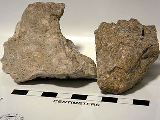
Ignimbrite is a type of volcanic rock, consisting of hardened tuff. Ignimbrites form from the deposits of pyroclastic flows, which are a hot suspension of particles and gases flowing rapidly from a volcano, driven by being denser than the surrounding atmosphere. New Zealand geologist Patrick Marshall (1869–1950) coined the term ignimbrite from the Latin igni- [fire] and imbri- [rain].

The Rotorua Caldera is a large rhyolitic caldera that is filled by Lake Rotorua. It was formed by an eruption 240,000 years ago that produced extensive pyroclastic deposits. Smaller eruptions have occurred in the caldera since, the most recent less than 25,000 years ago. It is one of several large volcanoes in the Taupō Volcanic Zone on the North Island of New Zealand.

Kikai Caldera is a massive, mostly submerged caldera up to 19 kilometres (12 mi) in diameter in the Ōsumi Islands of Kagoshima Prefecture, Japan.

Hyskeir or Heyskeir is a low-lying rocky islet in the Inner Hebrides, Scotland. The Hyskeir Lighthouse marks the southern entrance to the Minch.
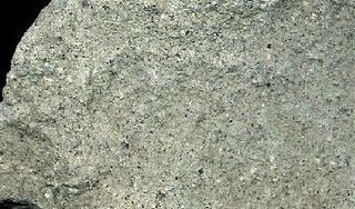
Rhyodacite is a volcanic rock intermediate in composition between dacite and rhyolite. It is the extrusive equivalent of those plutonic rocks that are intermediate in composition between monzogranite and granodiorite. Rhyodacites form from rapid cooling of lava relatively rich in silica and low in alkali metal oxides.

An Sgùrr is the highest hill on the Inner Hebridean island of Eigg, Lochaber, Highland, Scotland. It was formed 58.72 ± 0.07 million years ago; the result of one of the last eruptions of a volcano, the core of which now forms the Isle of Rùm. Thick viscous pitchstone lava of rhyodacitic composition flowed out, filling a river valley. The lava cooled and formed column-like structures, similar to those at Giant's Causeway.
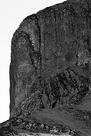
Pitchstone is a dark coloured, glassy volcanic rock formed when felsic lava or magma cools quickly. Since it is a volcanic glass, pitchstone may have a conchoidal fracture. Pitchstones may also contain phenocrysts, in which case it is a form of vitrophyre. Pitchstone has a resinous lustre, or silky in some cases, and a variable composition. Its colour may be mottled, streaked, or uniform brown, red, green, gray, or black. It is an extrusive rock that is very resistant to erosion.

La Garita Caldera is a large caldera and extinct supervolcano in the San Juan volcanic field in the San Juan Mountains around the town of Creede in southwestern Colorado, United States. It is west of La Garita, Colorado. The eruption that created the La Garita Caldera is among the largest known volcanic eruptions in Earth's history, as well as being one of the most powerful known supervolcanic events.

Torfajökull is a rhyolitic stratovolcano, with a large caldera capped by a glacier of the same name and associated with a complex of subglacial volcanoes. Torfajökull last erupted in 1477 and consists of the largest area of silicic extrusive rocks in Iceland. This is now known to be due to a VEI 5 eruption 55,000 years ago.

The Paraná-Etendeka Large Igneous Province (PE-LIP) (or Paraná and Etendeka Plateau; or Paraná and Etendeka Province) is a large igneous province that includes both the main Paraná traps (in Paraná Basin, a South American geological basin) as well as the smaller severed portions of the flood basalts at the Etendeka traps (in northwest Namibia and southwest Angola). The original basalt flows occurred 136 to 132 million years ago. The province had a post-flow surface area of 1,000,000 square kilometres (390,000 sq mi) and an original volume projected to be in excess of 2.3 x 10⁶ km3.

The North Atlantic Igneous Province (NAIP) is a large igneous province in the North Atlantic, centered on Iceland. In the Paleogene, the province formed the Thulean Plateau, a large basaltic lava plain, which extended over at least 1.3 million km2 (500 thousand sq mi) in area and 6.6 million km3 (1.6 million cu mi) in volume. The plateau was broken up during the opening of the North Atlantic Ocean leaving remnants preserved in north Ireland, west Scotland, the Faroe Islands, northwest Iceland, east Greenland, western Norway and many of the islands located in the north eastern portion of the North Atlantic Ocean. The igneous province is the origin of the Giant's Causeway and Fingal's Cave. The province is also known as Brito–Arctic province and the portion of the province in the British Isles is also called the British Tertiary Volcanic Province or British Tertiary Igneous Province.

The Akahoya eruption or Kikai-Akahoya eruption was the strongest known volcanic eruption of the Kikai Caldera in Kyūshū, Japan. It ejected 332–457 km3 (80–110 cu mi) of volcanic material, giving it a Volcanic Explosivity Index of 7.

This timeline of volcanism on Earth includes a list of major volcanic eruptions of approximately at least magnitude 6 on the Volcanic explosivity index (VEI) or equivalent sulfur dioxide emission during the Quaternary period. Other volcanic eruptions are also listed.
The Semilir eruption was a major volcanic event which took place in Indonesia during the Early Miocene. This eruption formed the Semilir Formation and Nglanngran Formation. These two geological formations are in the Southern Mountains of East Java. The eruption created two formations which consist of mostly pyroclastic rock. It has incredible thickness. In contrast, The Toba supereruption only formed 600 m (2,000 ft) ignimbrite. The estimated Semilir eruption age date by isotope method is 21 million years ago.
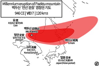
Paektu Mountain, also known as Changbaishan, on the border of the Democratic People's Republic of Korea and China erupted in late 946 CE. This event is known as the Millennium Eruption or Tianchi eruption. It is one of the most powerful volcanic eruptions in recorded history and is classified as a Magnitude 6.5-7 eruption.
Cerro Chascon-Runtu Jarita is a complex of lava domes located inside, but probably unrelated to, the Pastos Grandes caldera. It is part of the more recent phase of activity of the Altiplano-Puna volcanic complex.
Irruputuncu is a volcano in the commune of Pica, Tamarugal Province, Tarapacá Region, Chile, as well as San Pedro de Quemes Municipality, Nor Lípez Province, Potosí Department, Bolivia. The mountain's summit is 5,163 m (16,939 ft) high and has two summit craters—the southernmost 200 m (660 ft)-wide one has active fumaroles. The volcano also features lava flows, block and ash flows and several lava domes. The volcano is part of the Andean Central Volcanic Zone (CVZ).

Whakamaru Caldera was created in a massive supereruption 335,000 years ago and is approximately 30 by 40 km in size and is located in the North Island of New Zealand. It now contains active geothermal areas as well as the later Maroa Caldera.

The Mangakino caldera complex is the westernmost and one of oldest extinct rhyolitic caldera volcanoes in the Taupō Volcanic Zone of New Zealand's North Island. It produced about a million years ago in the Kidnappers eruption of 1,200 km3 (287.9 cu mi), the most widespread ignimbrite deposits on Earth being over 45,000 km2 (17,000 sq mi) and was closely followed in time by the smaller 200 km3 (48.0 cu mi) Rocky Hill eruption. The Kidnappers eruption had a estimated VEI of 8 and has been assigned a total eruption volume of 2,760 km3 (662.2 cu mi).


