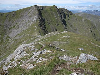
Sgùrr Choinnich is a mountain with a height of 999 metres (3,278 ft) in the Northwest Highlands of Scotland. Classed as a Munro, it is in the Achnashellach Forest area between Glen Carron and Loch Monar. It has mostly steep, grassy slopes, with a narrow summit ridge that runs east–west. There are crags on the northern side of this ridge, looking down into the corrie of Coire Choinnich.

Sgùrr a' Mhàim is a mountain of the Mamores range in the Scottish Highlands. It is directly south of Ben Nevis, on the other side of Glen Nevis. With a height of 1,099 metres (3,605 feet), Sgùrr a' Mhàim is a Munro and the second-highest peak in the Mamores. Its cap of quartzite stones give it a light grey appearance which can be mistaken for a covering of snow.

Sgurr na Lapaich is a mountain in the Northwest Highlands of Scotland, situated north of Loch Mullardoch in the high ground that separates Glen Cannich and Glen Strathfarrar. The mountain reaches a height of 1,150 metres, and is the fourth-highest mountain north of the Great Glen. There is no higher ground to the north of it in Great Britain.

Sgùrr Fhuaran is a Scottish mountain that is situated on the northern side of Glen Shiel, 23 kilometres (14 mi) east south east of Kyle of Lochalsh.

Sgurr a' Choire Ghlais is a mountain in the North-west Highlands of Scotland. It lies between Glen Strathfarrar and Glen Orrin and it is an excellent viewpoint, being the highest mountain in its group - a group which includes the Munros of Sgurr na Ruaidhe, Sgurr Fhuar-thuill and Carn nan Gobhar. Northwards there is no higher ground apart from the Fannichs.
Càrn nan Gobhar is a mountain rising to 993 metres (3,258 ft) in the Northwest Highlands of Scotland. It stands on the northern side of Loch Mullardoch in the upper part of Glen Cannich, in a remote group of four Munros informally known as "The Mullardochs" which form the high ground between Loch Mullardoch and Loch Monar.
Sgùrr a' Mhaoraich is a Scottish mountain located to the north of Loch Quoich in the northwestern highlands. It has a height of 1027 m (3369 ft) and is classed as a Munro. Viewed from Kinloch Hourn to the west, or from the north, it shows large, steep, rocky flanks with a complex series of ridges and corries, but like its neighbours such as Gleouraich, its southern side is gentler and grassier.

Sgùrr Thuilm is a mountain in the Glenfinnan area of the Highlands of Scotland. It stands at the head of Glen Finnan approximately 7 kilometres (4 mi) north of Loch Shiel.

Càrn nan Gobhar is a mountain rising to 992 metres (3,255 ft) in the Northwest Highlands of Scotland. It lies north of Glen Strathfarrar and south of Glen Orrin, some 40 kilometres west of the city of Inverness. It is usually climbed along with the neighbouring Munros of Sgurr a' Choire Ghlais and Sgurr na Ruaidhe.

Sgùrr na h-Ulaidh is a mountain lying to the south of the village of Glencoe in the Scottish Highlands. The mountain cannot be seen from the main A82 road as it is hidden behind Aonach Dubh a'Ghlinne.

Sgurr Mhurlagain is a mountain in the Northwest Highlands, Scotland, west of the village of Spean Bridge in Lochaber.

Meall Dubh is a mountain in the Northwest Highlands, Scotland. Lying near the village of Fort Augustus, it is the highest peak between the valleys of Glen Moriston and Glen Garry.

Sgùrr nan Conbhairean is a mountain in the Northwest Highlands of Scotland, lying north of Loch Cluanie and south of Glen Affric. A dome-shaped mountain with a height of 1,109 metres (3,638 ft), it is part of a group of three Munros, the other two being A' Chràlaig and Mullach Fraoch-choire.

Sgurr a' Chaorachain is a mountain with a height of 1,053 metres (3,455 ft) in the Northwest Highlands, Scotland. It lies in Wester Ross.

Sgurr Mhic Bharraich is a mountain in the Northwest Highlands, Scotland, at the head of Loch Duich in Ross-shire.

Sgùrr Breac is a mountain with a height of 999 metres (3,278 ft) in Wester Ross in the Northwest Highlands of Scotland. A remote mountain, Sgùrr Breac is part of the Fannichs range, and has a very steep north face. It is usually climbed from its eastern side. The nearest settlement is Auchindrean.

Sgurr na Feartaig is a mountain in the Northwest Highlands, Scotland. It is located northeast of Strathcarron in Wester Ross.

Sgurr nan Coireachan is a mountain in the Northwest Highlands, Scotland. It lies north of Glenfinnan in Lochaber.

Sgurr an Doire Lethain is a mountain in the Northwest Highlands of Scotland. It is located south of Glen Shiel in the Kintail area.

Sgurr nan Coireachan is a mountain in the Northwest Highlands of Scotland. It lies in the Lochaber region, near the head of the remote Glen Dessarry.

