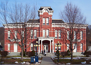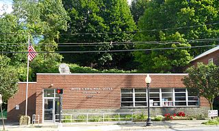
Susquehanna Depot, often referred to simply as Susquehanna, is a borough in Susquehanna County, Pennsylvania, located on the Susquehanna River 23 miles (37 km) southeast of Binghamton, New York. In the past, railroad locomotives and railroad cars were made here. It is also known for its Pennsylvania Bluestone quarries.
Red Clay Creek is a 13.6-mile-long (21.9 km) tributary of White Clay Creek, running through southeastern Pennsylvania and northern Delaware in the United States. As of 2000, portions of the creek are under wildlife habitat protection.
Dyberry Creek is a 7.3-mile-long (11.7 km) tributary of the Lackawaxen River in Wayne County, Pennsylvania, in the United States.
Licking Creek is a 56.6-mile-long (91.1 km) tributary of the Potomac River in Pennsylvania and Maryland in the United States.
Equinunk Creek is a 15.4-mile-long (24.8 km) tributary of the Delaware River in Wayne County, Pennsylvania in the United States.
Meshoppen Creek is a tributary of the Susquehanna River in Susquehanna and Wyoming counties, Pennsylvania, in the United States. It is approximately 30.6 miles (49.2 km) long and flows through Bridgewater Township, Dimock Township, and Springville Township in Susquehanna County and Lemon Township, Washington Township, Meshoppen Township, and Meshoppen in Wyoming County. The watershed of the creek has an area of 114 square miles (300 km2). It is possible to canoe on 17.0 miles (27.4 km) of Meshoppen Creek.

Martins Creek is a 20.4-mile-long (32.8 km) tributary of Tunkhannock Creek in northeastern Pennsylvania in the United States.
Middle Creek is a 20.7-mile-long (33.3 km) tributary of the Lackawaxen River in the Poconos of eastern Pennsylvania in the United States.

Town Creek is a 41.6-mile-long (66.9 km) tributary stream of the Potomac River in the U.S. states of Maryland and Pennsylvania. The creek is formed from the confluence of Sweet Root Creek and Elk Lick Creek, about 0.5 miles (0.8 km) south of Buchanan State Forest in Bedford County, Pennsylvania. Town Creek flows south along the base of Warrior Mountain into Allegany County, Maryland. The Chesapeake and Ohio Canal crosses it at the Town Creek Aqueduct. It empties into the Potomac about 4 miles (6 km) east of Oldtown, Maryland.
Mosquito Creek is a 21.8-mile-long (35.1 km) tributary of the West Branch Susquehanna River in central Pennsylvania in the United States.
Paradise Creek is a 9.6-mile-long (15.4 km) tributary of Brodhead Creek in the Poconos of eastern Pennsylvania in the United States.
Snake Creek is a 17.0-mile-long (27.4 km) tributary of the Susquehanna River in Susquehanna County, Pennsylvania, and Broome County, New York, in the United States.
Elk Creek is an 11.4-mile-long (18.3 km) tributary of Loyalsock Creek in Sullivan County, Pennsylvania in the United States.

Tunkhannock Creek is a 19.2-mile-long (30.9 km) tributary of Tobyhanna Creek in the Poconos of eastern Pennsylvania in the United States.
Mill Creek is an 18.7-mile-long (30.1 km) tributary of the Tioga River in Tioga County, Pennsylvania in the United States.
Sugar Creek is a 32.0-mile-long (51.5 km) tributary of the Susquehanna River in Bradford County, Pennsylvania in the United States.
Tobyhanna Creek is a 29.9-mile-long (48.1 km) tributary of the Lehigh River in the Pocono Mountains of eastern Pennsylvania in the United States.
Salt Lick Creek is an 11.1-mile-long (17.9 km) tributary of the Susquehanna River in Susquehanna County, Pennsylvania in the United States.