
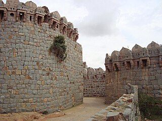
Kalaburagi, formerly known as Gulbarga, is a city in the Indian state of Karnataka, It is headquarters of eponymous Kalaburagi district and Kalaburagi division, Kalaburagi city is governed by a Municipal Corporation, It is called a Sufi city. It has famous religious structures, like the Hazrath Khwaja Banda Nawaz Dargah, the Sharana Basaveshwara Temple and the Buddha Vihar. It also has a fort built during the Bahmani rule, Other Bahmani monuments include the Haft Gumbaz and the Shor Gumbad. Kalaburagi has the world's largest cannon, Kalaburagi has a few architectural marvels built during the Bahamani Kingdom rule, including the Jama Masjid in the Kalaburagi Fort. Kalaburagi houses the circuit bench of the High Court of Karnataka. Under the name Monuments and Forts of the Deccan Sultanate, Several buildings in the city and with others in the region were put by UNESCO on its "tentative list" of World Heritage Site in 2014.

Shirdi is a town and pilgrimage site in the Indian state of Maharashtra. Shirdi is located in the Rahata taluka of Ahmednagar District. It is accessible via the Ahmednagar–Malegaon State Highway No.10, approximately 83 km (52 mi) from Ahmednagar and 15 km (9.3 mi) from Kopargaon. It is located 185 km (115 mi) east of the Ahmednagar–Manmad road.

Bijapur is the district headquarters of Bijapur district of the Karnataka state of India. It is also the headquarters for Bijapur Taluk. Bijapur city is well known for its historical monuments of architectural importance built during the rule of the Adil Shahi dynasty. It is also well known for the popular Karnataka premier league team, the Bijapur Bulls. Bijapur is located 519 km (322 mi) northwest of the state capital Bangalore and about 550 km (340 mi) from Mumbai and 210 km (130 mi) north east of the city of Belgaum.
Narayanpet is a town, & district headquarters of Narayanpet district of the Indian state of Telangana. It is located 165 km from the state capital Hyderabad and 62 km from Mahabubnagar. Narayanpet is the city famous for Silk and cotton Sarees. Narayanpet Sarees has unique style of sarees and biggest market in Telangana after Gadwal and Pochampally Sarees. Narayanpet is also hub for Gold merchants and the people visit to this town for shopping the gold ornaments due to quality and good services.

Ramagundam is a city under municipal corporation in Peddapalli district of the Indian state of Telangana. It is the most populous city in the district and falls under the Ramagundam revenue division. It is located on the banks of the Godavari River. As of the 2011 census, the city had a population of 229,644, making it the 6th most populous in the state, and an urban agglomeration population of 242,979. It is located about 225 km from the state capital Hyderabad.
Yadgiri, also spelled as Yādagiri, is a city and the administrative headquarters of Yadgir district in the Indian state of Karnataka. It is also the administrative headquarters of Yadgir Taluku, one of the six taluks of Yadgir.
Wadi is a census town in Kalaburagi district in the Indian state of Karnataka.The Wadi Town Has a 23 Municipal Ward. The Wadi Junction railway station is an important railway junction on the Indian railways. Gulbarga, which is around 37 km via rail route and 40 km via roadway from Wadi The railway line from Secunderabad to Wadi was started in 1874.
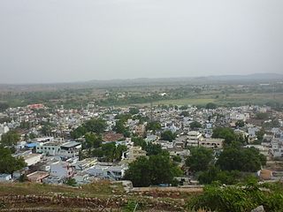
Chitapur or Chittapur is a town and taluk in Kalaburagi district in the state of Karnataka, India. It is also the headquarters of the Chittapur taluk. It is known for polished stones and toor dal.

Gurmitkal, or Gurumithakal, is a panchayat town in the northeast of Yadgir district in the Indian state of Karnataka. Administratively, it is under Gurumitkal Taluka.

Kinwat is a city which falls under the municipal council of the Nanded District, in the Indian state of Maharashtra. The Kinwat Taluka came into existence in 1905 when a number of villages from Narsapur,Tamsi, and Nirmal Talukas from the Adilabad District, were combined. Earlier, these villages were under the Hyderabad Division. In 2011, Kinwat had population of 28454 with literacy rate of 82% and female sex ratio of 929. Kinwat is 125 km away from Nanded city. Kinwat has Rural Hospital.
Kushtagi is a panchayat town in Koppal district in the Indian state of Karnataka. Kushtagi is a taluk center of Koppal district. This taluk has a population of 353,142 as per the 2021 census estimate. In this taluk, pomegranate fruits are popularly grown.There is a Durga devi temple in heart of the town. To its North lies Ilkal, Gajendragad to the West, Hospet to the South and Sindhanur to the East. Red and black soil can be found in this taluk. A big lake 4kms away from the city is the main source of drinking water is situated in west side and covering the area of more than 300 acres.
Lingasugur, also pronounced as Lingasugūru, is a municipal town in Raichur district in the Indian state of Karnataka. There are many Temples, hills and forts (Quila). The festivals of Muharram and Maha Shivaratri are important here. Mudgal in Lingasugur taluk has a very ancient fort. It has often been mentioned in the autobiography of Philip Meadows Taylor. Lingasugur, then known as Chavani was the site of a major British cantonment in the region.

Madukkarai is a suburb of Coimbatore city in the Indian state of Tamil Nadu. It is the gateway to Coimbatore city from Kerala State and is located around 12 km from the Kerala border. The Coimbatore International Airport is about 27 km from here. It is the administrative centre for Madukkarai taluk.
Mudgal is a Municipal town in Lingsugur taluk, Raichur district in the Indian state of Karnataka. Mudgal is about 10 miles south-west of Lingsugur.

Pappinisseri is a census town and a suburb of Kannur city in Kannur district in the Indian state of Kerala. Pappinissery have consistently won the Swaraj Trophy for best Grama Panchayat from 2017-2018 to 2021. Pappinisseri Panchayat also bagged the third position in the Swaraj Trophy during 2015-2016. Also, Pappinissery has been declared as the best Grama Panchayat in Kerala by Kerala government. Pappinisseri Panchayat comprises two villages, viz Pappinisseri and Aroli. Pappinisseri better known for visha chikitsa kendram
Sadashivpet is a town in Sangareddy district of the Indian state of Telangana.
Sedam or Seram is a town in Kalaburagi district in the Indian state of Karnataka. It is also the headquarters of the Sedam Taluka.

Tadipatri is a city in Anantapur district of the Indian state of Andhra Pradesh at the border of Nandyala district and Kadapa district. It is a Selection Grade Municipality City Council. Tadipatri is a headquarters of Tadipatri mandal in Anantapur revenue division. The Chintala Venkataramana Temple is located on a five-acre site in Tadipatri. The Bugga Ramalingeswara Temple is located one kilometer from the city, overlooking the Penna River.
Tandur is a town, Municipality and Mandal in Vikarabad district in the Indian State of Telangana. It is a municipality consisting of 36 wards, as well as the headquarters of Tandur Mandal in the Tandur Revenue Division. It is known for its production of Limestone, Cement, and Redgram . Drinking water is sourced from the River Kagna, a tributary of the Bhima River, which is 4 km from the town. The country's famous Tandur Redgram has been awarded the Geographical Indication (GI) by The Central Department of Commerce and Industry.

Hosadurga is a town and a taluk in Chitradurga district in the Indian state of Karnataka.
