Related Research Articles

Matabeleland South is a province in southwestern Zimbabwe. With a population of 683,893 as of the 2012 Zimbabwean census, it is the country's least populous province. After Matabeleland North, it is Zimbabwe's second-least densely populated province. Matabeleland South was established in 1974, when the original Matabeleland Province was divided into two provinces, the other being Matabeleland North. The province is divided into six districts. Gwanda is the capital, and Beitbridge is the province's largest town. The name "Matabeleland" is derived from Ndebele, the province's largest ethnic group.

Matabeleland is a region located in southwestern Zimbabwe that is divided into three provinces: Matabeleland North, Bulawayo, and Matabeleland South. These provinces are in the west and south-west of Zimbabwe, between the Limpopo and Zambezi rivers and are further separated from Midlands by the Shangani River in central Zimbabwe. The region is named after its inhabitants, the Ndebele people who were called "Amatabele"(people with long spears - Mzilikazi 's group of people who were escaping the Mfecani wars). Other ethnic groups who inhabit parts of Matabeleland include the Tonga, Bakalanga, Venda, Nambya, Khoisan, Xhosa, Sotho, Tswana, and Tsonga. The population of Matabeleland is just over 20% of the Zimbabwe's total.
The Ndau are an ethnic Shona subethnic group which inhabits the areas in south-eastern Zimbabwe in the districts of Chipinge and Chimanimani in which they are natives. They are also found in parts of Bikita, in the Zambezi valley, in central Mozambique all the way to the coast and in central Malawi. The name "Ndau" is a derivation from the people's traditional salutation "Ndau wee!" in greetings and other social settings. When the Ngoni observed this, they called them the Ndau people, the name itself meaning the land, the place or the country in their language. Some suggestions are that the name is derived from the Nguni words "Amading'indawo" which means "those looking for a place" as this is what the Gaza Nguni called them and the name then evolved to Ndau. This is erroneous as the natives are described in detail to have already been occupying parts of Zimbabwe and Mozambique in 1500s by Joao dos Santos. The five largest Ndau groups are the Magova; the Mashanga; the Vatomboti, the Madanda and the Teve. Ancient Ndau People met with the Khoi/San during the first trade with the Arabs at Mapungumbwe and its attributed to the Kalanga people not Ndau. They traded with Arabs with “Mpalu” “Njeti” and “Vukotlo’’ these are the red, white and blue coloured cloths together with golden beads. Ndau people traded traditional herbs, spiritual powers, animal skins and bones.
Shangani may refer to:

}
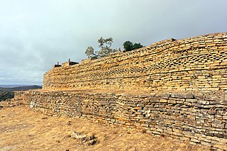
Naletale are ruins located about 25 kilometres east of Shangani in Matabeleland north, Zimbabwe and just north of the Dhlo Dhlo ruins.

The First Matabele War was fought between 1893 and 1894 in modern-day Zimbabwe. It pitted the British South Africa Company against the Ndebele (Matabele) Kingdom. Lobengula, king of the Ndebele, had tried to avoid outright war with the company's pioneers because he and his advisors were mindful of the destructive power of European-produced weapons on traditional Matabele impis attacking in massed ranks. Lobengula reportedly could muster 80,000 spearmen and 20,000 riflemen, armed with Martini-Henry rifles, which were modern arms at that time. However, poor training meant that these were not used effectively.

The Matabeleland Zambezi Water Project (MZWP) is an ambitious project being undertaken in the arid Matabeleland North province of Zimbabwe.The project seeks to end the perennial water shortages bedevilling Zimbabwe's second city of Bulawayo by bringing water from the mighty Zambezi river to the city.
Lupane ( luːpɑːnɛ) District is located in the Matabeleland North Province of Zimbabwe, and it is also the Provincial Capital. The District is situated at an elevation of 976 m with a population of 198,600 inhabitants by 2019. Lupane Town is the main center of the district located 172 km from Bulawayo along the A8 Victoria Falls Road. The Government Provincial Administrative offices are located at the Town Centre. A new university near the Town has been established under the name Lupane State University, which caters for the region and beyond. The word Lupane is thought to be a Kalanga or Lozwi word.
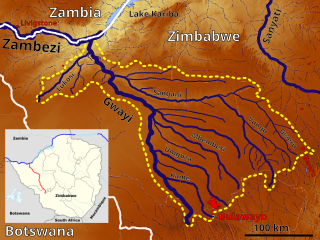
The Shangani is a river in Zimbabwe that starts near Gweru, Gweru River being one of its main tributaries' and goes through Midlands and Matabeleland North provinces. It empties into the Gwayi River.
Allan Wilson High school is a boys' high school in Harare, Zimbabwe, named after British Army officer Allan Wilson. Wilson led the Shangani Patrol in the First Chimurenga (war) against the people of Matabeleland. He died in that war near Shangani River, defending Rhodesians who were fighting to colonise Zimbabwe.
Lower Gwelo is a developed communal settlement in the Midlands province, Zimbabwe and is located about 40km north-west of Gweru, and stretches a further 50
United Nations Security Council resolution 777, adopted unanimously on 19 September 1992, after reaffirming Resolution 713 (1992) and all subsequent resolutions on the topic, the Council considered that, as the state known as the Socialist Federal Republic of Yugoslavia (SFRY) had ceased to exist, it noted that under Resolution 757 (1992), the claim by the Federal Republic of Yugoslavia to continue automatic membership in the United Nations was not widely accepted and so determined that membership of the SFRY in the United Nations could not continue. Therefore, the Council recommended to the General Assembly that the Federal Republic of Yugoslavia ceased participation in the General Assembly and apply for membership in the United Nations.

The Shangani Patrol was a 34-soldier unit of the British South Africa Company that in 1893 was ambushed and annihilated by more than 3,000 Matabele warriors in pre-Southern Rhodesia, during the First Matabele War. Headed by Major Allan Wilson, the patrol was attacked just north of the Shangani River in Matabeleland, Rhodesia. Its dramatic last stand, sometimes called "Wilson's Last Stand", achieved a prominent place in the British public imagination and, subsequently, in Rhodesian history, similarly to events such as the Battle of the Little Bighorn and the Battle of the Alamo in the United States.
Tichafa Samuel Parirenyatwa was Zimbabwe's first trained black physician, medical doctor and the first vice-president of the Zimbabwe African People's Union (ZAPU). He rose to prominence during ZAPU's political struggle against the colonial administration in Southern Rhodesia.

Public holidays in Rhodesia, a historical region in southern Africa equivalent to today's Zimbabwe and Zambia—formerly Southern and Northern Rhodesia, respectively—were largely based around milestones in the region's short history. Annual holidays marked various aspects of the arrival of white people during the 1880s and 1890s, as well as the respective unilateral declarations of independence (1965) and of republican government (1970). On these days, most businesses and non-essential services closed. A number of Christian holidays were also observed according to custom, in the traditional British manner, and referred to in official documents by name—Christmas Day, for example, or Easter Monday.

Gweru District is a district in the Midlands Province of Zimbabwe.

In 1949, Rhodesia played a rugby union match against New Zealand as a part of the 1949 New Zealand rugby union tour of South Africa. The match was played on 27 July 1949 at Hartsfield Rugby Ground in Bulawayo, Southern Rhodesia. The final result was Rhodesia 10–8 New Zealand. As of 2019, this is the only time the All Blacks have been beaten by a non-Test nation and makes Rhodesia one of only eight countries to have won against the All Blacks.
Zimbabwe has an active film culture that includes films made in Zimbabwe during its pre- and post-colonial periods. Economic crisis and political crisis have been features of the industry. A publication from the 1980s counted 14 cinemas in Zimbabwe's capital city, Harare. According to a 1998 report only 15 percent of the population had been to a cinema. European and American films have been made on location in Zimbabwe as well as Indian films. American films are popular in Zimbabwe but face restrictions limiting their distribution.
The Shangani Solar Power Station is a proposed 25 megawatts solar power plant in Zimbabwe. The project is under development by a Zimbabwean independent power producer (IPP), called Shangani Renewable Energy. It is expected that when this power station begins commercial operations, the energy generated here will be sold to the Zimbabwe Electricity Supply Authority (ZESA), for integration into the national grid.
References
- ↑ McCrea, Barbara; Pinchuck, Tony (2000). The Rough Guide to Zimbabwe. London: Penguin Group. pp. 179–180. ISBN 978-1858285320.
- ↑ Murray, Paul (2013). Zimbabwe. Bradt Travel Guide. Guilford, Connecticut: Globe Pequot Press. p. 184. ISBN 978-1841624600.