This article is being considered for deletion in accordance with Wikipedia's deletion policy. Please share your thoughts on the matter at this article's entry on the Articles for deletion page. Feel free to improve the article, but the article must not be blanked, and this notice must not be removed, until the discussion is closed. For more information, particularly on merging or moving the article during the discussion, read the guide to deletion. |
| |
| Abbreviation | SCAM |
|---|---|
| Established | 1977 |
| Location | |
Founder | Fr. Michael Catalano, SJ [1] |
| Affiliations | Jesuit, Catholic |
| Website | SCAM |
Shanti Community Animation Movement was founded in 1977 by Jesuit Fr. Michael Catalano. His work began among shanty dwellers along the canals in Colombo, Sri Lanka, and extended to refugees from the 29-year civil war. The work depends largely on the contributed labor of volunteers and includes educational and building projects, while fostering peace, reconciliation, and human development among the diverse peoples of Sri Lanka. [1]
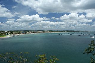
Colombo is the commercial capital and largest city of Sri Lanka. According to the Brookings Institution, Colombo metropolitan area has a population of 5.6 million, and 752,993 in the city proper. It is the financial centre of the island and a popular tourist destination. It is located on the west coast of the island and adjacent to the Greater Colombo area which includes Sri Jayawardenepura Kotte, the legislative capital of Sri Lanka and Dehiwala-Mount Lavinia. Colombo is often referred to as the capital since Sri Jayawardenepura Kotte is within the urban area of, and a suburb of, Colombo. It is also the administrative capital of the Western Province and the district capital of Colombo District. Colombo is a busy and vibrant place with a mixture of modern life and colonial buildings and ruins. It was the legislative capital of Sri Lanka until 1982.
Sri Lanka, officially the Democratic Socialist Republic of Sri Lanka, is an island country in South Asia, located in the Indian Ocean to the southwest of the Bay of Bengal and to the southeast of the Arabian Sea. The island is historically and culturally intertwined with the Indian subcontinent, but is geographically separated from the Indian subcontinent by the Gulf of Mannar and the Palk Strait. The legislative capital, Sri Jayawardenepura Kotte, is a suburb of the commercial capital and largest city, Colombo.
The Sri Lankan Civil War was an armed conflict fought on the island of Sri Lanka. Beginning on 23 July 1983, there was an intermittent insurgency against the government by the Liberation Tigers of Tamil Eelam, which fought to create an independent Tamil state called Tamil Eelam in the north and the east of the island. After a 26-year military campaign, the Sri Lankan military defeated the Tamil Tigers in May 2009, bringing the civil war to an end.
Fr. Catalano began his work among shanty-dwellers along the canal banks in the densely-packed capital of Sri Lanka, and spread to 12 centers. [1] Besides those living along the Wellawatte and Dehiwela canals in Colombo, Shanti serves the resettlement areas in Kilinochchi and Mullaitivu. It received approval from the Presidential Taskforce in its work for reconciliation in areas affected by the wars. [2] The restorative justice aspect of the movement has been greatly helped by government soldiers working alongside the poor to build homes, schools, and community centers in the resettled areas. [2] Professors from the Catholic University of Milan have trained teachers in giving psychosocial support to victims of war, [2] and volunteers from abroad come to assist in the project. [3] [4] Shanti also participates in an environmental training network. [5]
Wellawatte is a neighbourhood of Colombo, Sri Lanka. It lies immediately south of Bambalapitiya and is classified as zone 6 within the Colombo Municipal region. The town begins at the old Dutch canal just before the Savoy Cinema and extends south to the same canal that reaches the sea just before the Hospital Road junction where Dehiwela begins. It is bounded on the west by the waters of the Indian Ocean and extends to Pamankade where Havelock Road forks and meets the Sri Saranankara Road bridge, which stretches over the Dutch canal, extending towards Kohuwela-Hospital Road junction on Dutugemunu Street.
Dehiwala-Mount Lavinia, population 245,974 (2012) is the largest suburb of the City of Colombo, and covers an extent of 2109 hectares. It lies south of the Colombo Municipal Council area and separated from it by the Dehiwala canal which forms the northern boundary of DMMC. Its southern limits lie in Borupana Road and the eastern boundary is Weras Ganga with its canal system and including some areas to its east. This town has extensive population and rapid industrialization and urbanization in recent years. It is home to Sri Lanka's National Zoological Gardens, which remains one of Asia's largest. Colombo South Teaching Hospital, Kalubowila and Colombo Airport, Ratmalana are some important landmark in this area. Dehiwela-Mount Lavinia and Sri Jayawardenapura Kotte being two large suburban centers of the city of Colombo function together as one large urban agglomeration in the Region. The overspill from the City in residential and commercial uses of land have rapidly urbanised these suburban centers. Dehiwela-Mount Lavinia and Sri Jayawardenpaura along with Colombo Municipal Council form the most urbanized part of the core area of the Colombo Metropolitan Region. Dehiwala and Mount Lavinia lie along the Galle Road artery, which runs along the coast to the south of the country.
Kilinochchi is the main town of Kilinochchi District, Northern Province of Sri Lanka. Kilinochchi is situated at the A9 road some 100 km (62 mi) south-east of Jaffna. It was the administrative center and de facto capital of the LTTE until 2 January 2009, when troops of the Sri Lankan Army recaptured the city.
Over 39 years SACM has evolved and grown to include the following programs at most of six centers.
Trincomalee also known as Gokanna/Gokarna, is the administrative headquarters of the Trincomalee District and major resort port city of Eastern Province, Sri Lanka. Located on the east coast of the island overlooking the Trincomalee Harbour, 237 kilometres (147 mi) north-east of Colombo, 182 kilometres (113 mi) south-east of Jaffna and 111 kilometres (69 mi) miles north of Batticaloa, Trincomalee has been one of the main centres of Sri Lankan Tamil language speaking culture on the island for over two millennia. With a population of 99,135, the city is built on a peninsula of the same name, which divides its inner and outer harbours. People from Trincomalee are known as Trincomalians and the local authority is Trincomalee Urban Council. Trincomalee city is home to the famous Koneswaram temple alluded to in its historic Tamil name Thirukonamalai and is home to other historical monuments such as the Bhadrakali Amman Temple, Trincomalee, the Trincomalee Hindu Cultural Hall and, opened in 1897, the Trincomalee Hindu College. Trincomalee is also the site of the Trincomalee railway station and an ancient ferry service to Jaffna and the south side of the harbour at Muttur.
Moratuwa is a large suburb of Colombo city, on the southwestern coast of Sri Lanka, near Dehiwala-Mount Lavinia. It is situated on the Galle–Colombo main highway, 18 km south of Colombo city centre. Moratuwa is surrounded on three sides by water, except in the north of the city, by the Indian Ocean on the west, the Bolgoda lake on the east and the Moratu river on the south. According to the 2012 census, the suburb had a population of 168,280.
Coordinates: 6°52′6.3″N79°52′0.47″E / 6.868417°N 79.8667972°E

A geographic coordinate system is a coordinate system that enables every location on Earth to be specified by a set of numbers, letters or symbols. The coordinates are often chosen such that one of the numbers represents a vertical position and two or three of the numbers represent a horizontal position; alternatively, a geographic position may be expressed in a combined three-dimensional Cartesian vector. A common choice of coordinates is latitude, longitude and elevation. To specify a location on a plane requires a map projection.