Iğdır Province is a province in eastern Turkey, located along the borders with Armenia, Azerbaijan, and Iran. Its adjacent provinces are Kars to the northwest and Ağrı to the west and south. It occupies an area of 3,587 km2 and population of 184,418, it was 168,634 in 2000. It was created from southeastern part of former Kars Province in 1993.

Yevlakh is a city in Azerbaijan, 265 km west of capital Baku. It is surrounded by, but administratively separate from, the rayon of the same name. The city forms a distinct administrative division of Azerbaijan.

Ordubad is a rayon of Azerbaijan in the Nakhchivan Autonomous Republic. Ordubad district was established in 1930. In 1963, the district was abolished and given to the Julfa region. Since 1965, it has been an independent district. It borders on Iran in the south, Armenia in the north and west and Julfa region in the east and covers an area of 972 square kilometres (375 sq mi). There is 1 city, 3 settlements, and 43 villages within the district. The administrative centre of the district is the Ordubad city.

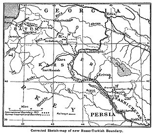
The Treaty of Kars was a peace treaty that established the common borders between Turkey and the three Transcaucasian republics of the Soviet Union. The treaty was signed in the city of Kars on 13 October 1921.

Ağstafa is a town and municipality in, and the capital of, the Agstafa Rayon of Azerbaijan. Historically it was a train station.

Aghvorik is a village and rural community (municipality) in the Shirak Province of Armenia. The National Statistical Service of the Republic of Armenia (ARMSTAT) reported its population was 118 in 2010, up from 90 at the 2001 census.

Alvar is a village and rural community (municipality) in the Shirak Province of Armenia.

Aregnadem is a village and rural community (municipality) in the Shirak Province of Armenia. The National Statistical Service of the Republic of Armenia (ARMSTAT) reported its population was 342 in 2010, down from 407 at the 2001 census.

Gtashen is a village and rural community (municipality) in the Shirak Province of Armenia.

Byurakn ; formerly known as Gyullibulagh Armenian: Գյուլլիբուլաղ, Azerbaijani: Güllübulaq, is a village and rural community (municipality) in the Shirak Province of Armenia. The National Statistical Service of the Republic of Armenia (ARMSTAT) reported its population was 926 in 2010, up from 781 at the 2001 census.

Shaghik is a village in the Shirak Province of Armenia.

Tsaghkut, is a village in the Shirak Province of Armenia.

Voghji is a village in the Shirak Province of Armenia. Until 1991 the village's name was Okhchogly or Okhchoglu.

Zorakert is a village in the Shirak Province of Armenia.

Hajiqabul is a town and municipality in and the capital of Hajigabul District of Azerbaijan. It has a population of 23,512. The municipality consists of the city of Qazıməmməd and the village of Balıqçı.

Dashalty, is a village in Nagorno-Karabakh, which is de jure part of Azerbaijan and de facto part of the Republic of Artsakh. The population consists of ethnic Armenians, and both the Azerbaijani and Armenian names of the village mean below-the-rock, referring to the sheer vertical cliffs towering above the village, on top of which Shusha is built.

Qars is a former village in the Khizi Rayon of Azerbaijan. The village formed part of the municipality of Tıxlı.

Dəmirçi is a village and the most populous municipality, except for the capital Şərur, in the Sharur District of Nakhchivan Autonomous Republic, Azerbaijan. It is located in the near of the Nakhchivan-Sadarak highway, 11 km in the north-west from the district center, on the Sharur plain. Its population is busy with grain-growing, vegetable-growing, beet-growing and animal husbandry. There are two secondary schools, cultural house, library, kindergarten, hospital and a "Binamaz Əhməd" sacred place of 18th century in the village. It has a population of 5,092.

Karkush is a village in Aland Rural District, Safayyeh District, Khoy County, West Azerbaijan Province, Iran. At the 2006 census, its population was 594, in 113 families.

Ezzatabad-e Sharm Dasht is a village in Eshkevar-e Sofla Rural District, Rahimabad District, Rudsar County, Gilan Province, Iran. At the 2006 census, its population was 197, in 48 families.


