Red Bluff Provincial Park is a provincial park in British Columbia, Canada.
Smith River Falls – Fort Halkett Provincial Park is a provincial park in British Columbia, Canada, protecting Smith River Falls and the former Fort Halkett, a Hudson's Bay Company trading post. The park is located at the confluence of the Smith and Liard Rivers.
Sustut Provincial Park and Protected Area is a provincial park in British Columbia, Canada, located on the east side of the Sustut River and above the Bear River. Established by order-in-council in 2001, the park has an area of 75,037 ha. The park protects the Hogem Ranges and the Connelly Range and is in the traditional territories of the Tsay Keh Dene First Nation and the Gitxsan First Nation.

The Gwa'Sala-Nakwaxda'xw Nations are a union of two Kwakwaka'wakw peoples in a band government based on northern Vancouver Island in British Columbia, Canada, whose main reserve community is near the town of Port Hardy in the Queen Charlotte Strait region of the Central Coast region of British Columbia, Canada. The band government is a member of the Kwakiutl District Council and, for treaty negotiation purposes, the Winalagalis Treaty Group which includes three other members of the Kwakiutl District Council.
Kwikwasut'inuxw Haxwa'mis, formerly the Kwicksutaineuk-ah-kwa-mish First Nation is a First Nations band government based on northern Vancouver Island in British Columbia, Canada, in the Queen Charlotte Strait region. It is a member of the Musgamagw Tsawataineuk Tribal Council, along with the ‘Namgis First Nation and the Tsawataineuk First Nation. The Kwikwasut'inuxw and Haxwa'mis are two of the many subgroups of the peoples known as Kwakwaka'wakw, which means "speakers of Kwak'wala", their language, and were combined into one band by the Department of Indian and Northern Affairs.
The Machmell River, also spelled Machmel River, is a river in the Pacific Ranges of the southern Coast Mountains in British Columbia, Canada. It flows west into Owikeno Lake.
Owikeno Lake, also Owekeeno Lake, Owekano Lake, Oweekayno Lake and other spellings, is a large fjord lake in the Central Coast region of British Columbia, Canada. It connects to the head of Rivers Inlet by the short Wannock River (Wanukv). The lake's name comes from the indigenous people of the region, the Wuikinuxv, whose settlements and territory lie around the lake. Their largest and principal settlement was on an island in the lower reaches of the lake named Katit.
The Kingcome River is a river in the Canadian province of British Columbia. Its drainage basin is 1,456 square kilometres (562 sq mi) in size.
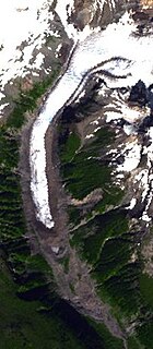
The Kingcome Glacier is a glacier located at the head of the Kingcome River in southwestern British Columbia, Canada.
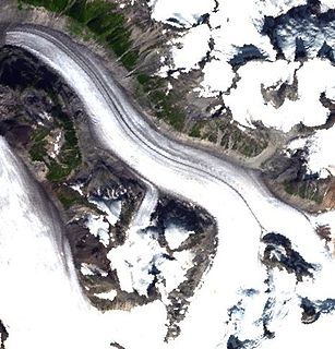
The Pashleth Glacier is a glacier south of the Machmell River and west of the Klinaklini Glacier in southwestern British Columbia, Canada.

The Terminal Range is the northernmost mountain range of the Canadian Rockies, so-named for its position at the northern terminus of the Rockies. Lying west of Muncho Lake and the Trout River, its northern perimeter is the Liard River. The Sentinel Range lies to its east.
The Asseek River is a river in the Central Coast region of British Columbia, Canada, flowing north out of the Pacific Ranges to enter saltwater at the head of South Bentinck Arm. The name has been used since 1930, but an earlier map from 1913 shows it as the Talolail River. Also entering South Bentinck Arm a few miles north on the east side of the inlet is the Taleomey River, whose estuary forms Taleomey Narrows, a constriction of the inlet, and also where is the location of Taleomy Indian Reserve No. 3 of the Nuxalk Nation. Another constriction south of the Taleomey estuary, and immediately north of the Asseek's mouth is Bentinck Narrows, which is formed by the alluvial fan of Ickna Creek.
The Sakumtha River is a river in British Columbia, Canada, flowing south out of the Kitimat Ranges from an origin west of the Tsaydaychuz Peak massif into the Dean River north of Bella Coola.
The Atlatzi River is a river in the Pacific Ranges in the Central Coast region of British Columbia, Canada, flowing southwest into the lower Kingcome River, which feeds the head of Kingcome Inlet. It had been called Back River on a 1919 map of British Columbia. Its headwaters are at 51°03′N125°52′W.
The Satsalla River is a river in the Pacific Ranges of the Coast Mountains in British Columbia, Canada, flowing southwest into the Kingcome River. Like the Atlatzi River, another major tributary of the Kingcome farther south, its origins are on the edge of the Ha-Iltzuk Icefield.
The Clear River is a river in the Central Coast region of British Columbia, Canada, flowing east out of the Pacific Ranges of the Coast Mountains into the Kingcome River, of which it is a tributary. Other tributaries of the Kingcome are the Atlatzi and the Satsalla.
The Tzeo River is a river in the Central Coast region of British Columbia, Canada, flowing generally south out of the Pacific Ranges into the head of Owikeno Lake.
The Inziana River is a river in the Central Coast region of British Columbia, Canada, flowing east out of the Pacific Ranges into the head of Owikeno Lake.
The Neechantz River is a river in the Central Coast region of British Columbia, Canada, flowing north out of the Pacific Ranges into the Machmell River just before its mouth into the head of Owikeno Lake.
The Washwash River is a river in the Central Coast region of British Columbia, Canada, flowing generally west out of the Pacific Ranges into the Tzeo River just above the Tzeo's mouth into the head of Owikeno Lake.


