
Joub Jannine is located in the Beqaa Valley in Lebanon.
Wadi al-Far'a is a Palestinian village in the Tubas Governorate in the northeastern West Bank located five kilometers southwest of Tubas. It has a land area of 12,000 dunams, of which 337 is built-up and 10,500 are for agricultural purposes. It is under the complete control of the Palestinian National Authority and is adjacent to the Far'a refugee camp. According to the Palestinian Central Bureau of Statistics, Wadi al-Far'a had a population of 2,340 inhabitants.
Aammiq is a village in the Western Beqaa District in Lebanon. It is also the name of an archaeological site.

Qaraoun is a Lebanese village, 85 km from Beirut, known for its Lake Qaraoun in the Beqaa Valley formed by the El Wauroun Dam built in 1959. It is an ecologically fragile zone in the Western Beqaa District. The village lies about 800 m above sea level. The dam is located nearby on the Litani River.
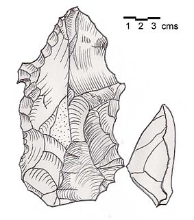
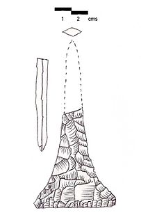
Heavy Neolithic is a style of large stone and flint tools associated primarily with the Qaraoun culture in the Beqaa Valley, Lebanon, dating to the Epipaleolithic or early Pre-Pottery Neolithic at the end of the Stone Age. The type site for the Qaraoun culture is Qaraoun II.
Mtaileb or Mtayleb is a suburb north of Beirut in the Matn District of Mount Lebanon Governorate in Lebanon.
Ourrouar is a series of archaeological sites approximately 8.5 kilometres (5.3 mi) south southeast of Beirut, Lebanon. It is near Hadeth south on the north side of the Nahr Ghedir.
Tell Mureibit is a Heavy Neolithic archaeological site approximately 8 kilometres (5 mi) north of Tyre, Lebanon. It is located in a wadi near Qasimiye, Qasimiyeh or Kasimiyeh on the north bank of the Litani river. Material was collected by E. Passemard which is kept in the National Museum of Beirut. It consists of heavy, rough and usually bifacial tools of indeterminate date that has been likened to other Heavy Neolithic material of the Qaraoun culture.
Wadi Sallah is a branch of the Wadi Fa'rah where a small cave is located in the Palestinian Tubas Governorate in the northeastern West Bank, located five kilometers southwest of Tubas. The cave was discovered and excavated by Francis Turville-Petre between 1925 and 1926. It contained an occupational Heavy Neolithic archaeological site of the Qaraoun culture. This culture was without pottery and typically used large axes for chopping lumber, cutting wood and felling trees such as the cedars of Lebanon in preparation for the domestication of emmer wheat and the Neolithic Revolution. Levels II and III of Turville-Petre's excavations revealed deposits of flints and potsherds. The pottery was later in date that the Heavy Neolithic material, which included heavy blades, massive flake scrapers, and pieces with denticulation, all similar to those found at Shemouniyeh and Wadi Fa'rah. Several arrowheads were also found that were pressure flaked, generally tanged and leaf-shaped. One of these was of the Amuq 2 type.
Bustan Birke or Boustan el Birke is a Heavy Neolithic archaeological site of the Qaraoun culture that is located 2.5 kilometres (1.6 mi) southeast of Kefraya, Lebanon.
Amlaq Qatih or Amlaq el Qatih is a Heavy Neolithic archaeological site of the Qaraoun culture that is located 2.5 kilometres (1.6 mi) northwest of Baaloul, 5 kilometres (3.1 mi) north of Qaraoun, Lebanon.
Kfar Tebnit or Kfar Tibnit is a village located approximately 4 kilometres (2.5 mi) south southeast of Nabatieh, 37 kilometres (23 mi) southeast of Sidon in Lebanon.
Ard Saouda or Ard es Saoude is a Heavy Neolithic archaeological site of the Qaraoun culture that is located in the Wadi al-Taym, between Rashaya and Marjayoun in Lebanon. It is south of the branch road to Qaraoun and Kaukaba at cote 990, on the surface of fields covered in large blocks of basalt, made from an ancient lava.
Khallet Michte is a Heavy Neolithic archaeological site of the Qaraoun culture located in the Caza of Bint Jbeil in the Nabatiye Governorate in Lebanon. The two sites Khallet Michte I and Khallet Michte II are located in adjacent wadis on south facing slopes between a track and the main road between Bint Jbeil and Ain Ebel. They were found by Henri Fleisch and noted to contain both Heavy Neolithic and Acheulean flint tools which are now in the collection of the Museum of Lebanese Prehistory at the Saint Joseph University.

Wadi Koura is a wadi located west of Ain Ebel in the Bint Jbeil District of Nabatieh Governorate in Lebanon.

Wadi Yaroun, Wadi Yarun, Wadi Jarun, Wadi Hanine, Jarun or Jareon is a wadi located south of Ain Ebel in the Bint Jbeil District of Nabatieh Governorate in Lebanon. After it reaches Yaroun it is called the Wadi Nahle or Wadi Nalesh and after reaching Debel it is called the Wadi Ayun et Tannour.

Flaoui or Fleywe or Flaoueh is a small village located 17 kilometres (11 mi) northwest of Baalbek, Lebanon in Baalbek District, Baalbek-Hermel Governorate, Lebanon. It is located near the north–south road that runs from Bodai to Chlifa.
Khallet el Hamra or Khallet Hamra is a ravine or wadi joining the larger Wadi Yaroun located 1 kilometre (0.62 mi) southeast of Ain Ebelin the Bint Jbeil District of Nabatieh Governorate in Lebanon.
Douwara is a Heavy Neolithic archaeological site of the Qaraoun culture located 2 kilometres (1.2 mi) southwest of Ain Ebel in the Bint Jbeil District of Nabatieh Governorate in Lebanon. It is located on slopes north of the road from Ain Ebel to Rmaich.
Wadi al-Far'a or Tirzah Stream is a stream in the northern West Bank that empties into the Jordan River south of Damia Bridge. It is the largest stream in the West Bank. Wadi al-Far'a is located in the rugged area of the West Bank and cuts east through the Jordan Valley, passing through the Palestinian village of Wadi al-Far'a. The Tirzah Reservoir is used to collect the floodwater of Wadi al-Far'a before it flows into the Jordan River.
