
Khyber Pakhtunkhwa, formerly known as North West Frontier Province (NWFP), is a province of Pakistan. Located in the northwestern region of the country, Khyber Pakhtunkhwa is the fourth largest province of Pakistan by land area and the third-largest province by population. It is bordered by Balochistan to the south; Punjab, Islamabad Capital Territory, and Azad Kashmir to the east; and Gilgit-Baltistan to the north and northeast. It shares an international border with Afghanistan to the west. Khyber Pakhtunkhwa has a varied geography of rugged mountain ranges, valleys, rolling foothills, and dense agricultural farms.
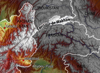
The Wakhan Corridor is a narrow strip of territory in the Badakhshan province of Afghanistan. This corridor stretches eastward, connecting Afghanistan to Xinjiang, China. It also separates the Gorno-Badakhshan Autonomous Region of Tajikistan in the north from the Khyber Pakhtunkhwa and Gilgit-Baltistan regions of Pakistan in the south, the latter of which is also part of the disputed region of Kashmir. This high mountain valley, which rises to a maximum altitude of 4,923 m (16,152 ft), serves as the source of both the Panj and Pamir rivers, which converge to form the larger Amu Darya River. For countless centuries, a vital trade route has traversed this valley, facilitating the movement of travelers to and from East, South, and Central Asia.

Gilgit is a city in Pakistani-administered Gilgit–Baltistan in the disputed Kashmir region. It is the capital of the Gilgit-Baltistan region. The city is located in a broad valley near the confluence of the Gilgit and the Hunza rivers. It is a major tourist destination in Pakistan, serving as a hub for trekking and mountaineering expeditions in the Karakoram mountain range.
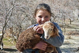
The Wakhi people, also locally referred to as the Wokhik, are an Iranian ethnic group native to Central and South Asia. They are found in Afghanistan, Tajikistan, Pakistan and China—primarily situated in and around Afghanistan's Wakhan Corridor, the northernmost part of Pakistan's Gilgit−Baltistan and Chitral, Tajikistan's Gorno−Badakhshan Autonomous Region and the southwestern areas of China's Xinjiang Uyghur Autonomous Region. The Wakhi people are native speakers of the Wakhi language, an Eastern Iranian language.

Chitral is a city situated on the Chitral River in northern area of Khyber Pakhtunkhwa. It serves as the capital of the Lower Chitral District, and was previously the capital of Chitral District, and before that the capital of Chitral princely state. The region was encompassed into West Pakistan between the years 1969 and 1972. It has a population of 49,780 per the 2017 census.

The Yidgha language is an Eastern Iranian language of the Pamir group spoken in the upper Lotkoh Valley of Chitral in the Khyber Pakhtunkhwa province of Pakistan. Yidgha is similar to the Munji language spoken on the Afghan side of the border.

The Munji language, also known as Munjani, Munjhan (مونجهان), and the Munjiwar language, is a Pamir language spoken in the Munjan valley in the Kuran wa Munjan district of the Badakhshan province in northeast Afghanistan. It is similar to the Yidgha language, which is spoken in the Upper Lotkoh Valley of Chitral, west of Garam Chashma in Khyber Pakhtunkhwa, Pakistan.

Yasin Valley is a high-altitude mountain valley nestled in the Hindu Kush mountain range, located in the northern region of the Gupis-Yasin District within Gilgit-Baltistan. The valley is situated approximately 148 kilometers from the city of Gilgit, which serves as the capital of Gilgit-Baltistan. Within the valley's territory lies Yasin Tehsil, an administrative subdivision of the region.

Dir is a region in northwestern Pakistan in the Khyber Pakhtunkhwa, in the foothills of the Himalayas. Before the independence of Pakistan, Dir was a princely state, and it remained so until 1969 when it was abolished by a presidential declaration, and the Dir District was created the following year. The area covers 5,280 square kilometres. In 1996 Dir district was officially divided into Lower Dir District and Upper Dir District.
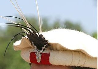
The Pakol or Pakul also called a Chitrali hat, is a soft, flat, rolled-up, round-topped men's cap, usually worn in Pakistan and Afghanistan. It was originally worn by the Chitrali people in northern Pakistan, and it forms a major part of their traditional attire. It is typically made of wool and found in a variety of earthy colours, such as brown, black, grey, ivory, or dyed red using walnut.

Upper Dir District is a district located in the Malakand Division of Khyber Pakhtunkhwa province of Pakistan. The city of Dir is its district headquarter. Geographically, it is located in the northern part of Pakistan. It borders with the Chitral district on the north, Afghanistan on the northwest, the Swat district on the east, and the Lower Dir district on the south. It shares 40 to 50 kilometers border with Afghanistan.

Dir was a princely state in a subsidiary alliance with the British Raj, located within the North-West Frontier Province. Following the Partition of British India, Dir remained independent and unaligned until February 1948, when the Dominion of Pakistan accepted its accession.

The Kalash, or Kalasha, are a small Indo-Aryan indigenous (minority) people residing in the Chitral District of the Khyber-Pakhtunkhwa province of Pakistan. The term is also used to refer to several distinct Nuristani speaking people, including the Väi, the Čima-nišei, the Vântä, plus the Ashkun- and Tregami-speakers.
Tajiks in Pakistan are residents of Pakistan who are of Tajik ancestry. The Tajiks are a Persian-speaking Iranian ethnic group native to Central Asia, living primarily in Afghanistan, Tajikistan, and Uzbekistan.
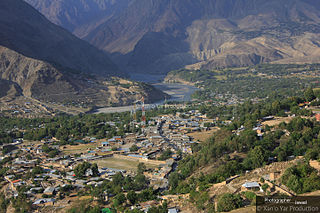
Drosh is a town located in the Lower Chitral District of the Khyber Pakhtunkhwa Province of Pakistan.
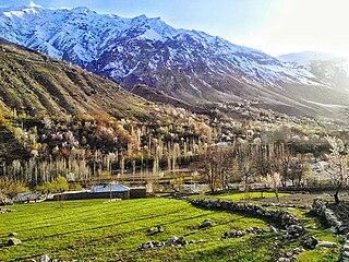
Garam Chashma is one of the many branch valleys of Chitral District, situated in the extreme north-west of Pakistan. It is one of the highest human settlements in the Hindukush ranges with an altitude of almost 2550 meters. The place is known for its hot spring, which is one of the tourist attraction sites. It is also famous for its trout fish. The water flowing down through the length of the valley is famous for fishing sports. The Lotkoh River running down from the lofty peaks of the Hindu Kush is most suitable for the brown type of trout fish. Other features of the area include snow-covered peaks, pleasant weather, and natural springs, and more recently, has remained in the limelight for being a potential site of hydropower generation. Besides tourists, people suffering from skin diseases also visit the hot spring for treatment. It is located in the northwest of Chitral at a distance of about forty-eight kilometres by road. It shares international borders with Afghanistan being situated in the extreme northwest of Pakistan. Dorāh Pass connects this part of Pakistan with Badakhshan, the adjacent province of Afghanistan.
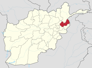
The 2017 Afghanistan avalanches were a series of avalanches that struck villages on the Afghanistan–Pakistan border between February 4 and 6, 2017. More than 100 people reportedly died in the disaster, including more than 50 people in Nuristan Province and at least 19 people in the neighbouring Badakhshan area of Pakistan's Chitral region. Dozens of homes and fhams were destroyed, and hundreds of animals died due to the avalanches. In Pakistan, the affected areas included regions of Balochistan, Mastung, Kalat and Kharan.

Upper Chitral District is an administrative district in the province of Khyber Pakhtunkhwa, Pakistan. Kho people are the dominant ethnic group in the district, forming 99.84% of the total population.
The Yidgha-Munji people also known as Mukhbani are the Iranian-Pamiri peoples inhabiting the Lotkoh Valley in Chitral and Kuran wa Munjan District in Badakhshan in both Pakistan and Afghanistan.
Madaklasht is a valley located in Lower Chitral district, Khyber Pakhtunkhwa, Pakistan.


