
Fort York is a historic site of military fortifications and related buildings located in the Fort York neighbourhood, west of downtown Toronto, Ontario, Canada. The fort was built by the British Army and Canadian militia troops in the late 18th and early 19th centuries, to defend the settlement and the new capital of the Upper Canada region from the threat of a military attack, principally from the newly independent United States. It was designated a National Historic Site in 1923. The City of Toronto designated the site, along with the nearby Fort York Armoury, as a Heritage Conservation District in 1985.

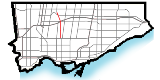
Spadina Avenue is one of the most prominent streets in Toronto, Ontario, Canada. Running through the western section of downtown, the road has a very different character in different neighbourhoods.

Toronto—St. Paul's is a federal electoral district in Toronto, Ontario, Canada, that has been represented in the House of Commons of Canada since 1935. Its current MP is Carolyn Bennett. Prior to the 2015 election, the riding was known as St. Paul's.
William R. Allen Road, also known as Allen Road and The Allen is a short expressway, super-4 expressway, and arterial road in Toronto, Ontario, Canada. It starts as a controlled-access expressway at Eglinton Avenue West north to Transit Road, then continues as a super-4 expressway north to De Boers Drive, and afterwards continues as an arterial road north to Kennard Avenue, where it continues north as the northern portion of Dufferin Street. Allen Road is named after late Metro Toronto Chairman William R. Allen and is maintained by the City of Toronto. Landmarks along the road include the Lawrence Heights housing project, Yorkdale Shopping Centre and Downsview Park. A section of the Toronto subway Line 1 Yonge–University is located within its median from Eglinton Avenue to north of Wilson Avenue, and briefly runs parallel to it underground in the vicinity of Sheppard Avenue.

Spadina is a subway station on Line 1 Yonge–University and Line 2 Bloor–Danforth in Toronto, Ontario, Canada. It is located on Spadina Road, north of Bloor Street West. It is the only station open overnight, along with Union station. Wi-Fi service is available at this station.

After the Williams Omnibus Bus Line had become heavily loaded in 1861, the city of Toronto issued a transit franchise for a horse-drawn street railway. The winner was Alexander Easton's Toronto Street Railway which opened the first street railway line in Canada on September 11, 1861, operating from Yorkville Town Hall to the St. Lawrence Market. The second line was on Queen Street. On other routes, the TSR continued to operate omnibuses. By 1868 the railway passed into the hands of the bondholders, and in 1869 the company was sold. In 1873 a new act of incorporation was obtained under the old name.

Bloor Street is a major east–west residential and commercial thoroughfare in Toronto, Ontario, Canada. Bloor Street runs from the Prince Edward Viaduct, which spans the Don River Valley, westward into Mississauga where it ends at Central Parkway. East of the viaduct, Danforth Avenue continues along the same right-of-way. The street, approximately 25 kilometres (16 mi) long, contains a significant cross-sample of Toronto's ethnic communities. It is also home to Toronto's famous shopping street, the Mink Mile.

Front Street is an east-west road in downtown Toronto, Ontario, Canada. First laid out in 1796, the street is one of the original streets of the Town of York. The street was laid out along the shoreline of Lake Ontario as it existed during that time. It remains an important street, with many important uses located along it, including the St. Lawrence Market, the Sony Centre for the Performing Arts, Union Station and the Metro Toronto Convention Centre. The eastern section of Front Street, in the West Don Lands, east of Cherry Street, is being rebuilt as a broad tree-lined boulevard, intended to be pedestrian friendly commercial spine of the new neighbourhood.
The Queen Street subway line is a proposed subway line for the city of Toronto, Ontario, Canada. It was one of many subway lines planned for, but has yet to be built by the Toronto Transit Commission.

The Garden District is a neighbourhood in downtown Toronto, Ontario, Canada. The name was selected by the Toronto East Downtown Residents Association (TEDRA) in recognition of Allan Gardens, an indoor botanical garden located nearby at the intersection of Carlton and Jarvis Streets. The Garden District was officially designated by the Mayor and Toronto City Council in 2001, while TEDRA has since been renamed the Garden District Residents Association. Part of the neighbourhood is within official City of Toronto neighbourhood of Moss Park.
The Relief Line is a proposed rapid transit line for the Toronto subway system, intended to provide capacity relief to the Yonge segment of Line 1 and Bloor–Yonge station and extend subway service coverage. Several routes are being considered. Several plans for an east–west downtown subway date back to the early 20th century, most of which ran along Queen Street. Since the early 21st century, studies propose a line that would run south from Line 2 Bloor–Danforth at a point east of the Don River, before bending westward along Queen Street into Downtown Toronto. Potential extensions could be made northward from its Line 2 connection in the east, as well as westward and northward from downtown to form a wide U-shape.

Castle Frank Brook is a buried creek and south-west flowing tributary of the Don River in central and north-western Toronto, Ontario, originating near the intersection of Lawrence Avenue and Dufferin Street.
Fort York was a provincial electoral district in Toronto, Ontario, Canada. It was created in 1987 and was subsequently abolished in 1999 when the ridings were redistributed to match their federal counterparts. The riding had only two representatives:

St. George was a provincial riding in Ontario, Canada, that returned Members of Provincial Parliament (MPPs) to the Legislative Assembly of Ontario at Queen's Park. It was created in downtown Toronto in 1926 and was merged into the riding of St. George—St. David in 1987. The seat covered much of the city's central core, roughly similar to the current riding of Toronto Centre. At its dissolution it stretched from University Avenue to Parliament Street and from the waterfront north past St. Clair.
St. David was an Ontario provincial riding that existed from 1926 to 1987. It covered a section of the eastern city of Toronto east of Sherbourne Street and west of the Don River. The riding lasted until 1987 when it was merged with the neighbouring St. George to create a larger district called St. George—St. David.
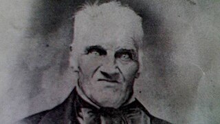
Joseph Bloor (1789–1862) was an innkeeper, brewer, and land speculator in the 19th century who founded the Village of Yorkville and is the namesake for Toronto's Bloor Street. Originally from Staffordshire, England, he emigrated to Canada in 1819 and eventually moved to the village of York, Upper Canada with his wife Sarah and three children, where he became a prominent early figure.
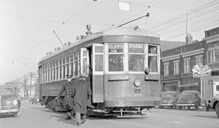
The Toronto Transit Commission operated a separate Spadina streetcar line on Spadina Avenue, from 1923 to 1948. Spadina Avenue is a major north–south road in downtown Toronto.

The Toronto Railway Company operated the Toronto Railway Company Belt Line from 1891 until 1921, when its operations were taken over by the Toronto Transportation Commission. The TTC continued operating the line until 1923, when it was broken up into separate routes, the Spadina streetcar line, the Bloor streetcar line, the King streetcar line, and the Sherbourne streetcar line.


