Sheridan Hollow, Albany, New York

Last updated
Sheridan Hollow
Neighborhood
SheridanHollowAlbany.jpg
Chapel Street at the eastern end of the hollow, looking north towards the Palace Theater
Etymology: General Philip Sheridan, US Civil War
USA New York location map.svg
Red pog.svg
Sheridan Hollow
Location of Sheridan Hollow within the state of New York
Coordinates: 42°39′26″N73°45′29″W / 42.65722°N 73.75806°W / 42.65722; -73.75806
Country United States
State New York
County Albany County
City Albany
Population
 (2000)
  Total791
Time zone UTC-5 (Eastern Standard Time)
  Summer (DST) UTC-4 (Eastern Daylight Time)
Area code 518
ZIP Code 12207, 12210

Sheridan Hollow is a neighborhood in Albany, New York located in a ravine north of Downtown Albany. Capitol Hill to the south and Arbor Hill to the north flank the ravine. Often the neighborhood is overlooked by city residents, and outsiders who work in the neighborhood often don't recognize the name of the neighborhood. [1] This is due to the identity of the Hollow being subsumed into its larger neighbor Arbor Hill, for instance news stories of events are often accredited to the wrong neighborhood. [2] [3] Being on undesirable land for development in colonial times, growth was slow in the Hollow and the neighborhood was populated through the centuries by a series of ethnic groups new to Albany, such as the Irish, Polish, and African Americans.

Contents

History

1790 map of Albany by Simeon De Witt, the Hollow with Foxes Creek is the ravine to the right DeWittmapofAlbany1790.jpg
1790 map of Albany by Simeon De Witt, the Hollow with Foxes Creek is the ravine to the right

The Vossenkill or Vozenkill was the kill that formed the ravine; kill being Dutch for creek. [4] The creek was named for Andries de Vos, an early settler, [5] and in the late-1700s the name was anglicized to Foxes Creek or Foxenkill. The creek and associated ravine were passed over in the initial growth of settlement at Beverwyck and colonial Albany until the late 1700s.  [4]

The northern edge of the 1750 Albany stockade ran along the southern rim of the Sheridan Hollow ravine, along what is now Columbia Street. A 1758 British Army map shows a road extending through the ravine, and in 1762 the city's Common Council ordered a "Publick Street remain in the Foxes Creek" up to and "as farr as the Schytt Bergie", the Schytt Bergie (Dutch for "Dung Hill"), being a hill made of deposited horse dung between present-day Central and Western avenues. [6] In 1763 the land north from Foxes Creek to the city line, which was the northern rim of the Hollow and future Clinton Avenue, was auctioned off primarily to tanners. This area was at the time called Woutenbergh, Dutch for woodland. [7]

In 1764 a grid iron street plan by John Bleeker was established for the city outside the stockade. Clinton Avenue (Patroon Street at the time) being the northern border of the city this plan included Sheridan Hollow. The plan was not fully implemented until 1794 as adapted by Simeon De Witt. [8] In the Bleeker plan the previous "Publick Street" was mostly turned into Howe Street, but as part of the removal of British names in 1790 Howe became Fox Street. [4] [6] Other streets in Sheridan Hollow whose names changed in 1790 were Wall Street became Hare (today Orange), Boscawen Street to Swan, Hawke Street to Hawk, Warren Street to Dove, Johnson Street to Lark, and Gage Street to Swallow (today Henry Johnson Boulevard). [9]

During the US Revolutionary War Tories were supposedly hanged and buried here in Sheridan Hollow. [8]

On a map made by De Witt in 1790 the name of Arbor Hill makes its first appearance on a map of Albany. In this map Arbor Hill is located in Sheridan Hollow between Orange Street and Clinton Avenue (south and north) and from Chapel Street halfway to Hawk Street (east to west); later Arbor Hill would be the name given to the Ten Broeck Mansion and surrounding neighborhood on the other side of Clinton Avenue, [10] the former village of Colonie. On this same map a "Negro burial ground" is shown along the southern rim of the Hollow, this burial ground does not show up on any subsequent maps and it may never have been plotted and used. [11]

Prior to 1797 Fox Street was a dirt road on the south side of Fox Creek, in 1797 the creek was channelized to flow behind the houses being built on the north side of the Fox Street which was renamed Canal Street. [4] [6] It was also in 1797 that the area west of Pearl Street were subdivided and sold, houses soon cropped up on Canal, Van Schaick (modern Monroe), and Orange streets. [4] With the introduction of underground sewers beginning in 1854 the Fox Creek was turned into a 6-foot (1.8 m) diameter sewer under Canal Street. [12]

In 1815 a city directory listed approximately 40 African American households, of which 11 were in Sheridan Hollow. [13] [14] Dinah Jackson, the first known African American property owner in Albany, owned several lots throughout Sheridan Hollow. [15]

Hawk Street Viaduct in 1905; over Sheridan Hollow facing west towards State Capitol and Cathedral of All Saints. HawkStreetViaduct1905.jpg
Hawk Street Viaduct in 1905; over Sheridan Hollow facing west towards State Capitol and Cathedral of All Saints.

In 1890 a viaduct was built carrying Hawk Street from Clinton Avenue to Elk Street, and in 1896 another was built to carry Northern Boulevard over most of Sheridan Hollow from Central Avenue to Sheridan Avenue. [16] The Hawk Street Viaduct was the first ever cantilever arch bridge. [17] In 1900 Canal Street was renamed Sheridan Avenue in honor of US Civil War General Philip Sheridan who was born at 83 Canal Street. [16]

At the turn of the 19th century residents throughout Albany had high incidents of parasite infestation (such as roundworm and ringworm). Whereas the incidents of infection declined throughout the 1800s citywide, Sheridan Hollow's infection rates stayed high until the turn of the 20th century. Residents in Sheridan Hollow continued to use outhouses and wells that may have been contaminated well into the 1920s. [18] During the 19th and early 20th centuries Sheridan Hollow was a predominantly immigrant neighborhood with a high rate of turnover as immigrant families moved up in social status to other neighborhoods and new immigrants moved in. Between 1917 and 1936 the turnover rate was 91%. [19] The western section of the neighborhood bordering West Hill became dominated by Polish immigrants who built St. Casimir's Church in 1893, which closed in 2003.

In 1925 the Hawk Street Viaduct was rebuilt but by 1949 the bridge had once again fallen into disrepair and plans to refurbish the bridge fell through in 1958. In 1968 the bridge was closed to traffic and became pedestrian only, and demolished in 1970. [20] The Northern Boulevard Viaduct was replaced in 1980. Today Northern Boulevard is Henry Johnson Boulevard.

In 1982 an oil burning steam generating plant in Sheridan Hollow was converted to burn garbage at the suggestion of Mayor Erastus Corning 2nd as part of the Albany New York Solid Waste Energy Recovery System (ANSWERS). Since Sheridan Hollow is a ravine and the smoke stacks are high enough to be at the level with the surrounding rim most of the pollution from the stacks ended up in neighboring Arbor Hill. Allen Hershkowitz, director of the Solid Waste and Energy Project for INFORM, a conservation research organization, said of the plant in 1986 that it "is the worst plant I've seen in the world." [21] The garbage burning aspect of the plant was closed in 1994 by order of Governor Mario Cuomo. [22]

Starting in the mid-1990s the eastern edge of Sheridan Hollow began to develop as part of a revival of Downtown Albany. A three-story bar and restaurant called The Big House Brewing Company on Sheridan Avenue and owned by Sheridan Hollow, Inc, was one of two "mega-bars" credited with bringing "after hours" life back to downtown. [23] A Hampton Inn and Suites was built nearby on Chapel Street between Sheridan and Monroe in 2005, it hosts a local restaurant and bar, Yono's. [24] Though the owners closed the Big House to concentrate on other projects and the Skyline restaurant and lounge failed to successfully replace it, the building is now being renovated into studio and one-bedroom apartments with first floor retail or restaurant space. [25] Plans by the city are for more residential units at this end of the Hollow, in order to bring more people within walking distance of downtown. Part of this plan is to redevelop the former Boyd Printing Company building on Sheridan Avenue. Current plans are to keep the main four-story building as commercial and to build a new seven-story residential building between it and the Hampton Inn. [26]

As part of the construction for a 1,380 car, 7-story parking garage by the state of New York along the southern rim of the Hollow, an archaeological study was performed to determine if the African American burial grounds shown on the 1790 De Witt plan were present. No traces of the cemetery were found in the 2-acre (0.81 ha) site of the garage. A memorial to the history of African Americans in Albany was built as part of the parking garage. [27]

Geography

Sheridan Hollow is, as its name suggests, a low-lying area (ravine) between two uplands, Capitol Hill to the south and Arbor Hill to the north. Clinton Avenue runs along the northern rim and Columbia and Elk streets run along the southern rim. The Hollow gently slopes up towards the west and at a sharper increase between Henry Johnson Boulevard and Lexington Avenue; the Hollow ends at the eastern edge of West Hill. [8] Whereas most other ravines and creeks in Albany were filled in throughout the centuries, Sheridan Hollow was too deep, [8] so growth in this part of the city remained stagnant and led to the isolation of Arbor Hill from Downtown.

Demographics

As of the 2000 census, there were 791 people residing in Sheridan Hollow, as defined from North Pearl Street west to Henry Johnson Boulevard and from Columbia and Spruce streets north to Clinton Avenue. The neighborhood had 35% under the age of 14, 10% from 15 to 24, 33% from 25 to 44, 16% from 45 to 64, and 5% who were 65 years of age or older. 54% of the population is female. Of the population 25 and older, 28% of the population did not complete high school, 28% had only a high school diploma, 38% had some college experience or an associate degree, 6% had a bachelor's degree, and 2% a Master's or higher. [1]

There were 324 households in 2000, out of which 40% had children under the age of 18 living with them, 20% were married couples living together, 30% had a female householder with no husband present, and less than 1% were non-families. 40% of all households were made up of individuals. 36% of all households had an income of less than $10,000; 30% had household income between $10,000 and $39,999; 33% between $40,000 and $59,999; and 1% over $60,000. [1]

Transportation

Henry Johnson Boulevard is carried over Sheridan Hollow on a viaduct. HenryJohnsonBlvdBridge.jpg
Henry Johnson Boulevard is carried over Sheridan Hollow on a viaduct.

Sheridan Hollow, being a ravine, can not be accessed easily from the north and south rims. From the south rim there are no roads that make the step decline into the ravine, several stairways allow for pedestrian access. Stairways connect Elk Street to Sheridan Avenue at Dove Street and at Swan Street. [28] On the north rim, listed from east to west, Chapel, North Hawk, Swan, Dove, and Lark streets climb steeply up the ravine to Clinton Avenue. East of Chapel North Pearl Street is at the open end of the ravine and is relatively flat. Henry Johnson Boulevard at the western edge of the ravine crosses Sheridan Hollow on a viaduct. Orange Street and Sheridan Avenue are the only two eastwest streets that span the length of the hollow. Lark Street is also a part of US Route 9W, the northern terminus of US 9W is at Clinton Avenue which is US Route 9.

Notable residents

Related Research Articles

<span class="mw-page-title-main">Lark Street</span>

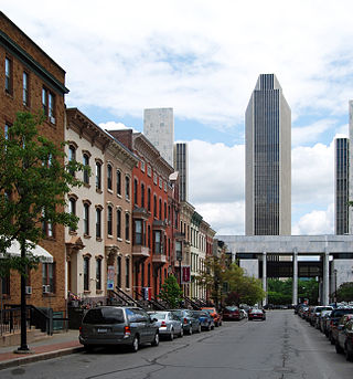
Lark Street is a historic street in Albany, New York, US. It is part of the Arbor Hill, Sheridan Hollow, Center Square, Park South and Hudson/Park neighborhoods, and is located one block east of Washington Park. Lark Street is the site of many independently owned shops, coffee houses, restaurants, art galleries, antique shops, marketing agencies, bars and tattoo shops. Although the part between Madison Avenue and Washington Avenue was rebuilt in 2002-2003 to place new roadways, trees and sidewalks in front of the new shops in the active portion of Lark Street, some local residents have protested against the neglect of the northern end of the street, which runs down into the less-affluent Arbor Hill neighborhood. Lark Street and Jay Street was used as a location during the filming of Ironweed. The Washington Avenue Armory is located at the corner of Lark Street and Washington Avenue.

Columbus, the state capital and Ohio's largest city, has numerous neighborhoods within its city limits. Neighborhood names and boundaries are not officially defined. They may vary or change from time to time due to demographic and economic variables.

<span class="mw-page-title-main">Neighborhoods of Albany, New York</span>

The neighborhoods of Albany, New York are listed below.

<span class="mw-page-title-main">Villa Park, Denver</span>

Villa Park is a neighborhood in the city of Denver, Colorado. Its hilly topography provides panoramic views of downtown Denver and of the Rocky Mountains, particularly from Lakewood / Dry Gulch Park, which divides the neighborhood diagonally.

<span class="mw-page-title-main">Clinton Avenue Historic District (Albany, New York)</span> Historic district along street in Albany, NY, USA

The Clinton Avenue Historic District in Albany, New York, United States, is a 70-acre (28 ha) area along that street between North Pearl and Quail streets. It also includes some blocks along neighboring streets such as Lark and Lexington.

<span class="mw-page-title-main">Streets of Albany, New York</span> Streets of Albany, New York

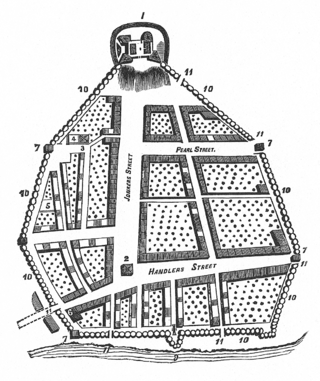
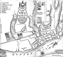
The streets of Albany, New York have had a long history going back almost 400 years. Many of the streets have changed names over the course of time, some have changed names many times. Some streets no longer exist, others have changed course. Some roads existed only on paper. The oldest streets were haphazardly laid out with no overall plan until Simeon De Witt's 1794 street grid plan. The plan had two grids, one west of Eagle Street and the old stockade, and another for the Pastures District south of the old stockade.

<span class="mw-page-title-main">Arbor Hill, Albany, New York</span> Neighborhood in Albany County, New York, United States

Arbor Hill is a neighborhood in Albany, New York, generally defined as the area from Clinton Avenue north to Tivoli Hollow and the Livingston Avenue Railroad Bridge and from Broadway west to Henry Johnson Boulevard. Both Clinton Avenue and Henry Johnson Boulevard are signed as U.S. Route 9. It was outside Albany's first boundaries as set up in the Dongan Charter of 1686. The original name of the area was Colonie, and the area was incorporated under that name as a village in 1804; it was annexed by Albany in 1815. There are two sub-neighborhoods in Arbor Hill, Dudley Heights and the Ten Broeck Triangle. "Arbor Hill" was the name given to the Ten Broeck estate; the Ten Broeck Mansion is still an important cultural and historical museum. The neighborhood has other historical and cultural sights such as the Palace Theatre and St. Joseph's Church. Demographically it is predominantly African-American.

Normansville is a former hamlet in Albany County, New York, United States. In the 19th century, Normansville was a hamlet in the town of Bethlehem. Normansville was located within and along the north and south banks of the ravine carved by the Normans Kill Creek, a tributary of the Hudson River.

<span class="mw-page-title-main">Downtown Schenectady</span> Neighborhood/Central business district in Capital District, New York, United States

Downtown Schenectady is the central business district for the city of Schenectady, New York. It originated in the 1820s with the moving of the commercial and industrial interests east from the original 17th and 18th century settlement, spurred on by the development of the Erie Canal. Home to the headquarters and major manufacturing plants of two large corporations, General Electric and American Locomotive Company, Downtown Schenectady catered to tens of thousands of workers in its heyday. Typical of the post-industrial Northeastern United States and Upstate New York in particular, Downtown Schenectady saw a decline in manufacturing and population starting in the 1970s. Recent construction and renovation has caused the downtown area to become an entertainment mecca for New York's Capital District anchored by Proctor's Theatre.

<span class="mw-page-title-main">Architecture of Albany, New York</span>

The architecture of Albany, New York, embraces a variety of architectural styles ranging from the early 18th century to the present. The city's roots date from the early 17th century and few buildings survive from that era or from the 18th and early 19th century. The completion of the Erie Canal in 1825 triggered a building boom, which continued until the Great Depression and the suburbanization of the area afterward. This accounts for much of the construction in the city's urban core along the Hudson River. Since then most construction has been largely residential, as the city spread out to its current boundaries, although there have been some large government building complexes in the modernist style, such as Empire State Plaza, which includes the Erastus Corning Tower, the tallest building in New York outside of New York City.

<span class="mw-page-title-main">North Albany, Albany, New York</span> Neighborhood in Albany County, New York, United States

North Albany is a neighborhood in the city of Albany, New York. North Albany was settled in the mid-17th century by the Patroon of Rensselaerswyck and his tenants and later became a hamlet in the town of Watervliet. Due to the Erie Canal being constructed in 1825, North Albany saw immense growth, with the Albany Lumber District and an influx of Irish immigrants lending the area the name of Limerick. Home to many historic warehouses and row houses, North Albany continues to be an important industrial neighborhood. Recent efforts have begun to gentrify the neighborhood by adapting heavy industry/warehouse use to artistic and entertainment venues, such as a German beer garden, an amusement park, live music venues, and arts and crafts marketplaces.

Pine Hills is a neighborhood in Albany, New York, generally defined as the area from Manning Boulevard to the west, Woodlawn Avenue to the south, Lake Avenue to the east, and Washington Avenue to the north. The neighborhood consists mainly of freestanding multi-unit, duplex, and semi-detached houses and is home to Albany High School, the LaSalle school, the College of St. Rose, and the Alumni Quad of the University at Albany. Though mostly residential due to historical reasons from its founding, Pine Hills is home to two neighborhood commercial districts ; Middle Madison, from Partridge to Quail streets was designated first, and then a latter designated district, Upper Madison, from Main Avenue to North Allen Street. The area of Pine Hills east of Main Avenue and north of Myrtle Avenue is commonly referred to as the student ghetto due to its predominant population of college-age students. The area of Pine Hills west of Main Avenue features many large Queen Anne, Folk Victorian, and Colonial Revival homes. Upper Madison, where it meets Western Avenue near St. Rose is the center of a commercial area, complete with a movie theater, grocery store, fast food strip mall, retail, restaurants, a library, community playhouse, police station, pharmacy, and elementary school.

<span class="mw-page-title-main">Arbor Hill Historic District–Ten Broeck Triangle</span> Historic area of Albany, New York

The Arbor Hill Historic District–Ten Broeck Triangle, originally the Ten Broeck Historic District, is a seven-block area located within the Arbor Hill neighborhood north of what is today downtown Albany, New York, United States. In 1979 its easternmost third, the Ten Broeck Triangle, the second oldest residential neighborhood in the city, was recognized as a historic district and listed on the National Register of Historic Places. Four years later, the district was increased to its current size and renamed to reflect its expansion to include some of the rest of Arbor Hill.

<span class="mw-page-title-main">History of Albany, New York (1860–1900)</span>

The history of Albany, New York from 1860 to 1900 begins in 1860, prior to the start of the Civil War, and ends in 1900.

<span class="mw-page-title-main">Hawk Street Viaduct</span> Bridge in Albany, New York, U.S.

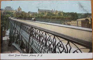
The Hawk Street Viaduct was a bridge spanning the Sheridan Hollow neighborhood in Albany, New York. It carried Hawk Street from Clinton Avenue to Elk Street. Completed in 1890, it was demolished in 1970 after decades of neglect which had caused it to be limited to pedestrian traffic only in 1968. It was the first cantilever arch bridge in the world.

<span class="mw-page-title-main">Lincoln Park (Albany, New York)</span> Urban park

Lincoln Park is an urban park in Albany, New York, with a unique history, from being the site of a skirmish in 1626 between the Dutch and Mohawks to brickyards and breweries to being Albany's first public playground. The park features Albany's only outdoor non-wading swimming pool, along with several tennis courts, basketball courts, and football and baseball fields. Within the park is the James Hall Office, a National Historic Landmark, and the Thomas O'Brien Academy of Science and Technology (TOAST) an elementary school.

The Tivoli Nature Preserve, also Tivoli Park, in Albany is the largest urban nature preserve in the Capital District.

<span class="mw-page-title-main">Saint Joseph's Church (Albany, New York)</span> Church in New York, United States

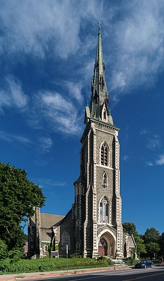
St. Joseph's Church is a historic neo-gothic church edifice in the Ten Broeck Triangle section of Albany, New York's Arbor Hill neighborhood. The structure is considered a city landmark and an important part of the Albany skyline. The church closed in 1994. The City of Albany placed the church for sale in February 2023.

<span class="mw-page-title-main">Neighborhoods in Lincoln, Nebraska</span>

Lincoln, Nebraska has many neighborhoods, including 45 recognized by Urban Development, City of Lincoln. A list and description of neighborhoods within Lincoln city limits follows.

References

  1. 1 2 3 University at Albany Fall 2010 Planning Studio (2010). "Sheridan Hollow: Steps Forward" (PDF). University at Albany, SUNY.{{cite web}}: CS1 maint: numeric names: authors list (link)
  2. "Corrections". Times Union (Albany). Hearst Communications. 2007-05-04. p. A2.
  3. "Corrections". Times Union (Albany). Hearst Communications. 2008-03-04. p. A2.
  4. 1 2 3 4 5 "Foxes Creek". New York State Museum. 2007-10-10. Archived from the original on 2010-05-27. Retrieved 2011-05-26.
  5. Wilcoxen, Charlotte (1984). Seventeenth Century Albany: A Dutch Profile. New York State Education Department and Albany Institute of History and Art. ISBN   0-939072-02-5.
  6. 1 2 3 Rittner, Don. "A Hollow Development".
  7. "Woutenbergh". New York State Museum. 2007-12-30. Retrieved 2011-05-26.
  8. 1 2 3 4 Waite, Diana S., ed. (1993). Albany Architecture: A Guide to the City. Matthew Bender IV-Mount Ida Press Partnership. ISBN   0-9625368-1-4.
  9. "Appendix". Albany County. Archived from the original on 2008-08-23. Retrieved 2011-05-26.
  10. "Arbor Hill". New York State Museum. Retrieved 2011-05-29.
  11. "Negro Burial Grounds". New York State Museum. 2004-03-24. Retrieved 2011-05-29.
  12. Howell, George Rogers & Tenney, Jonathan (1886). History of the County of Albany, N.Y. From 1609 to 1886. W.W. Munsell Co.
  13. Stefan Bielinski (2001-07-11). "Jacksons, Lattimores, and Schuylers". New York State Museum. Retrieved 2011-05-29.
  14. "Black Households-1815". New York State Museum. Retrieved 2011-05-29.
  15. Stefan Bielinski. "Dinnah Jackson". New York State Museum. Retrieved 2011-05-29.
  16. 1 2 Reynolds, Cuyler (1906). Albany Chronicles: A History of the City Arranged Chronologically. J.B. Lyon Company.
  17. "Hawk Street Viaduct, Albany, NY". Library of Congress. Retrieved 2011-05-29.
  18. "New York State Museum Press Release 06/05/08". New York State Museum. Retrieved 2011-05-28.
  19. Byron, Reginald (1999). Irish America. Oxford University Press. p. 170. ISBN   0-19-823355-8.
  20. "Historic American Engineering Record: Hawk Street Viaduct, Albany, Albany, New York". Office of Archeology and Historic Preservation, National Park Service, U.S Department of the Interior. 1970. Retrieved 2011-05-29.
  21. Lipman, Harvy (1986-10-01). "Garbage Problems Pile Up Modern Answer to Trash Dilemma Goes Up in Smoke". Times Union (Albany). Hearst Communications. p. A1.
  22. "The Answers Accord: The Issue Governor Cuomo and Mayor Jennings Have Found a Middle Ground in Determining Payment for the ANSWERS Plant. Our Opinion Both Sides Benefit From This Arrangement". Times Union (Albany). Hearst Communications. 1994-07-27. p. A6.
  23. Benjamin, Elizabeth (2001-02-18). "Downtown, Trouble Comes in Pints". Times Union (Albany). Hearst Communications. p. D1.
  24. Harlin, Kevin (2005-10-16). "Making Some More Room". Times Union (Albany). Hearst Communications. p. E1.
  25. Churchill, Chris (2011-01-14). "A Residential Renaissance in Downtown Albany?". Times Union (Albany). Hearst Communications.
  26. Churchill, Chris (2009-05-01). "Developer Plans Sheridan Avenue Apartment, Office Complex". Times Union (Albany). Hearst Communications.
  27. Nearing, Brian (2004-06-10). "Memorial Advances to Mark Burial Site for Blacks". Times Union (Albany). Hearst Communications. p. B1.
  28. "State Refurbishes Stairway at Center of Safety Dispute". Times Union (Albany). Hearst Communications. 1987-11-16. p. 5A.
  29. Hughes, Kyle (1986-07-06). "Politicos Left Their Stamps but Less Familiar Names Made Big Impressions on Albany, Too". The Knickerbocker News. Hearst Communications. p. T64.