
Sherman County is one of the 36 counties in the U.S. state of Oregon. As of the 2020 census, the population was 1,870, making it the second-least populous county in Oregon after nearby Wheeler. The county seat is Moro, and the largest city is Wasco. The county is named for William Tecumseh Sherman, a Union general in the American Civil War.

Sherman County is a county located in the U.S. state of Kansas. Its county seat is Goodland. As of the 2020 census, the county population was 5,927. Sherman County was created by the Legislature of 1873, and named after general William Sherman, a general during the American Civil War.

Annandale is a census-designated place (CDP) in Fairfax County, Virginia. The population of the CDP was 43,363 as of the 2020 United States Census. It is home to the oldest and largest branch of the Northern Virginia Community College system, and to one of the D.C. area's Koreatowns.

Wilkeson is a town in Pierce County, Washington, United States. The population was 499 at the 2020 census.

Knott's Berry Farm is a 57-acre (2,500,000 sq ft) theme park located in Buena Park, California, owned and operated by Six Flags. In March 2015, it was ranked as the twelfth-most-visited theme park in North America, while averaging approximately 4 million visitors per year. The park features over 40 rides, including roller coasters, family rides, dark rides, and water rides.

Elkhorn is a census-designated place (CDP) in Jefferson County, Montana, United States, in the Elkhorn Mountains of the southwestern part of the state. As of the 2010 census it had a population of 10. The community is considered a ghost town, and two of its buildings are preserved as Elkhorn State Park.

New Milford is a town in Litchfield County, Connecticut, United States. The town, part of Greater Danbury, as well as the New York Metropolitan Area, has a population of 28,115 as of the 2020 census. New Milford lies 14 miles (23 km) north of Danbury on the banks of the Housatonic River, and shares its border with the northeastern shore of Candlewood Lake. It is the largest town in the state of Connecticut in terms of land area at nearly 63.7 mi2 (164.9822 km2). The town center is listed as a census-designated place (CDP).

Columbia Heights is a neighborhood in Washington, D.C., located in Northwest D.C. Bounded by 16th Street NW, W Street NW, Florida Avenue NW, Barry Place NW, Sherman Avenue NW, Spring Road NW, and New Hampshire Avenue NW. neighborhood is an important retail hub for the area, as home to DC USA mall and to numerous other restaurants and stores, primarily along the highly commercialized 14th Street. Columbia Heights is home to numerous historical landmarks, including Meridian Hill Park, National Baptist Memorial Church, All Souls Church, along with a number of embassy buildings.
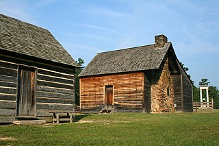
Bennett Place is a former farm and homestead in Durham, North Carolina, which was the site of the last surrender of a major Confederate army in the American Civil War, when Joseph E. Johnston surrendered to William T. Sherman. The first meeting saw Sherman agreeing to certain political demands by the Confederates, which were promptly rejected by the Union cabinet in Washington. Another meeting had to be held to agree on military terms only, in line with Robert E. Lee’s recent surrender to Ulysses S. Grant. This effectively ended the war.

The neighborhoods of Milwaukee include a number of areas in southeastern Wisconsin within the state's largest city at nearly 600,000 residents.
The Metropolitan Church Association, also known as the Metropolitan Methodist Mission and Metropolitan Evangelistic Church, is a Methodist denomination in the holiness movement. The Metropolitan Church Association has congregations throughout the world, and in the 20th century, it possessed intentional communities in Wisconsin, Virginia, West Virginia, Louisiana, and Texas, among other locations.
Bois d'Arc is a tiny unincorporated community in Anderson County, in the U.S. state of Texas. According to the Handbook of Texas, only 10 people lived in Bois d'Arc in 2000. It is a part of the Palestine, Texas micropolitan area. It has been termed a ghost town by www.TexasEscapes.com.

Grafton is a ghost town, just south of Zion National Park in Washington County, Utah, United States. Said to be the most photographed ghost town in the West, it has been featured as a location in several films, including 1929's In Old Arizona—the first talkie filmed outdoors—and the classic Butch Cassidy and the Sundance Kid. The nearest inhabited town is Rockville, which now includes the Grafton ghost town inside its legal boundaries.
Stoneham is an unincorporated community in Grimes County, Texas, United States. The town was once a part of a colony operated by Stephen F. Austin and by 1900, the population grew to 250. Although a ghost town by 1970, the town has since grown in population.
Locust Grove is an unincorporated community and ghost town in Sherman County, Oregon, United States. It is located on Oregon Route 206, six miles west of Wasco.
Sneed is a ghost town in Jackson County, Arkansas, United States.
Beulah is a ghost town in Angelina County, in the U.S. state of Texas. It is located within the Lufkin, Texas micropolitan area.
Peavy is a ghost town in Angelina County, in the U.S. state of Texas. It is located within the Lufkin, Texas micropolitan area.
Rocky Springs is a ghost town in Angelina County, in the U.S. state of Texas. It is located within the Lufkin, Texas micropolitan area.


