There is one government funded school in the village which provides education until grade 5, but not enough students attend to allow the school to function properly. Some children have relocated to Kathmandu to become Buddhist monks, while others have sought schooling overseas in hopes of a better life and education.
Most residents of the community are Buddhist; many of their ancestors were migrants from Tibet.
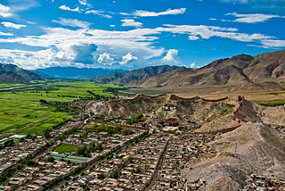
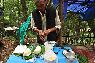
Upper Mustang is an upper part of Mustang District, which is located in Nepal. The Upper Mustang was a restricted kingdom until 1992 which makes it one of the most preserved regions in the world, with a majority of the population still speaking traditional Tibetic languages. Tibetan culture has been preserved by the relative isolation of the region from the outside world. Life in Mustang revolves around tourism, animal husbandry, and trade.
Princess Bhrikuti Devi of Licchavi is the first wife and queen of the emperor of Tibet, Songtsen Gampo, and an incarnation of Green Tara. She was also known as "Besa", and was a princess of the Licchavi kingdom of Nepal. She became the queen consort of Tibet c. 622.
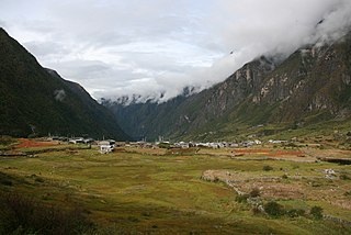
Langtang Valley is a Himalayan valley in the mountains of north-central Nepal, known for its trekking routes and natural environment.
A thangka is a Tibetan Buddhist painting on cotton, silk appliqué, usually depicting a Buddhist deity, scene, or mandala. Thangkas are traditionally kept unframed and rolled up when not on display, mounted on a textile backing somewhat in the style of Chinese scroll paintings, with a further silk cover on the front. So treated, thangkas can last a long time, but because of their delicate nature, they have to be kept in dry places where moisture will not affect the quality of the silk. Most thangkas are relatively small, comparable in size to a Western half-length portrait, but some are extremely large, several metres in each dimension; these were designed to be displayed, typically for very brief periods on a monastery wall, as part of religious festivals. Most thangkas were intended for personal meditation or instruction of monastic students. They often have elaborate compositions including many very small figures. A central deity is often surrounded by other identified figures in a symmetrical composition. Narrative scenes are less common, but do appear.
Gyantse, officially Gyangzê Town, is a town located in Gyantse County, Shigatse Prefecture, Tibet Autonomous Region, China. It was historically considered the third largest and most prominent town in the Tibet region, but there are now at least ten larger Tibetan cities.
Mustang District is one of the eleven districts of Gandaki Province and one of seventy-seven districts of Nepal which was a Kingdom of Lo-Manthang that joined the Federation of Nepal in 2008 after abolition of the Shah dynasty. It covers an area of 3,573 km2 (1,380 sq mi) and has a population (2011) of 13,452. The headquarters is located at Jomsom. Mustang is the 5th largest district of Nepal.
Rasuwa District (Nepali: रसुवा जिल्ला is one of 13 districts of Bagmati Province and one of seventy-seven districts of Nepal. The district, with Dhunche as its district headquarters, covers an area of 1,544 km2 and has a population of 43,300. Its own District Post Office has a Rasuwa DPO code of 45000. There are 5 post offices in the district, aiding residents with postal services throughout the area. As per census 2011 total households in Rasuwa district is 9,778. It is the smallest district by area, among 16 districts in the Himalaya region of Nepal.
Surkhet District is a district in Karnali Province of mid-western Nepal. Surkhet is one of the ten districts of Karnali located about 600 kilometres (373 mi) west of the national capital Kathmandu. The district's area is 2,489 square kilometres (961 sq mi). It had 288,527 population in 2001 and 350,804 in 2011 which male comprised 169,461 and female 181,381. Its district headquarters, Birendranagar, is the capital of Karnali Province. It is serving as a business hub and document center for Karnali province. According to population, development, road links, landforms, climate, many peoples are migrating here. After becoming province capital developmental activities are boosted and are in peak level. All the governmental works are carried here. Birendranagar is beautiful valley surrounded by hills having moderate climate.
Bandipur is a hilltop settlement and a rural municipality in Tanahun District, Gandaki province of Nepal. Bandipur is primarily known for its preserved, old time cultural atmosphere. At the time of the 2011 Nepal census it had a population of total 15,591 people living in 3,750 individual households.
Milarepa's Cave or Namkading Cave is a cave where the Tibetan Buddhist philosopher, and Vajrayana Mahasiddha, Milarepa spent many years of his life in the eleventh century. It is located 11 kilometres (7 mi) north of the town of Nyalam at Gangka village. It is on the slope below the China–Nepal Friendship Highway and above the Matsang river in Nyalam County, Tibet.
Helambu is a region of highland villages in Nepal, about 80 km from Kathmandu. It is the home of the Hyolmo people. The word Hyolmo derives from the word Helambu. The Helambu region begins at the Lauribina La pass and descends to the Melamchi valley. Helambu is famous for its sweet apples. and artistic Buddhist monasteries and it is a Buddhist pilgrimage site.
Dhulikhel is a municipality in Kavrepalanchok District of Nepal. Two major highway B.P. Highway and Araniko Highway passes through Dhulikhel. Araniko Highway connects Kathmandu, Nepal's capital city with Tibet's border town of Kodari. Dhulikhel is located at the Eastern rim of Kathmandu Valley, south of the Himalayas at 1550m above sea level and is situated 30 km southeast of Kathmandu and 74 km southwest of Kodari. The Majority of people in Dhulikhel are Newars, and Brahmin, Chhettri, Tamang and Dalit are also living in outer area of the town. Drinking water in Dhulikhel is some of the best water in Nepal. It was made with the help of the German NGO German Technical Cooperation.
Burtibang is a village development committee in Baglung District in the Dhaulagiri Zone of central Nepal. Burtibang is the second-largest commercial city in the district after Baglung.
Naikap Purano Bhanjyang is a village and former Village Development Committee that is now part of Chandragiri Municipality in Kathmandu District in Province No. 3 of central Nepal. At the time of the 1991 Nepal census it had a population of 3,456. The highest terrains in this village locate westerly, in ward No.5. A panoramic beautiful scene of whole Kathmandu Valley from Sanga to Nagarkot and Swayambhunath to Kirtipur Chobar can be viewed very clearly. The height of this hilly region lies in between 1600 m to 1800 m. The whole Himalayan range from Langtang to Mahalangur can also be viewed.
Nala, is a specific region that expands from north western part of Kavrepalanchowk District to the eastern part of Bhaktapur District in the Bagmati Zone of central Nepal. At the time of the 1991 Nepal census, it had a population of 6327 in 1035 individual households.
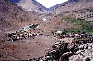
Langtang was a village development committee (VDC) in Rasuwa District in the Bagmati Zone of northern Nepal. It was located within the Langtang valley, approximately 40 miles northeast of Kathmandu. At the time of the 1991 Nepal census it had a population of 468 people living in 100 individual households.
The main religion in Tibet has been Buddhism since its outspread in the 8th century AD. As of 2022 the historical region of Tibet is mostly comprised in the Tibet Autonomous Region (TAR) of China and partly in the Chinese provinces of Qinghai and Sichuan. Before the arrival of Buddhism, the main religion among Tibetans was an indigenous shamanic and animistic religion, Bon, which would later influence the formation of Tibetan Buddhism and still attracts the allegiance of a sizeable minority of Tibetans.
Langtang National Park is a national protected area in north-central Nepal. It was established in 1976 as Nepal's first Himalayan national park and the country's fourth protected area. It covers an area of 1,710 km2 (660 sq mi) in the Nuwakot, Rasuwa and Sindhulpalchok Districts of the central Himalayan region. It contains 26 village communities and includes the Langtang valley. In the north and east it is linked with Qomolangma National Nature Preserve in the Tibet Autonomous Region. The eastern and western boundaries follow the Bhote Koshi and the Trishuli river, respectively.
The Trishuli River is one of the major tributaries of the Narayani River basin in central Nepal. The river is formed by the merger of Kyirong Tsangpo and Lende Khola originating in Gyirong County of Tibet, which join together near the Rasuwa Gadhi on the Nepal–Tibet border. The valley of the river provided the traditional trade route between the Kathmandu Valley and Tibet.
Naunglon is a village in Banmauk Township, Katha District, in the Sagaing Region of northern-central Myanmar about 230 mi south-east of Nay Pyi Taw, the country's capital, 38 mile from Bamauk and 35 miles from Pinlebu. It has 140 households and one Buddhist monastery, one primary school, and one pre-school. It is a middle sized village in that region. The village economy is mainly farming, digging for gold, and forests. Houses are built with timber and bamboo. The villagers are Buddhist and speak Shan and Kadu. The level of economic development, education and health care of the village is below the average.
This page is based on this Wikipedia article Text is available under the CC BY-SA 4.0 license; additional terms may apply. Images, videos and audio are available under their respective licenses.