
Lake Winnipeg is a very large, relatively shallow 24,514-square-kilometre (9,465 sq mi) lake in North America, in the province of Manitoba, Canada. Its southern end is about 55 kilometres (34 mi) north of the city of Winnipeg. Lake Winnipeg is Canada's sixth-largest freshwater lake and the third-largest freshwater lake contained entirely within Canada, but it is relatively shallow excluding a narrow 36 m (118 ft) deep channel between the northern and southern basins. It is the eleventh-largest freshwater lake on Earth. The lake's east side has pristine boreal forests and rivers that were in 2018 inscribed as Pimachiowin Aki, a UNESCO World Heritage Site. The lake is 416 km (258 mi) from north to south, with remote sandy beaches, large limestone cliffs, and many bat caves in some areas. Manitoba Hydro uses the lake as one of the largest reservoirs in the world. There are many islands, most of them undeveloped.

Northern Manitoba is a geographic and cultural region of the Canadian province of Manitoba. Originally encompassing a small square around the Red River Colony, the province was extended north to the 60th parallel in 1912. The region's specific boundaries vary, as "northern" communities are considered to share certain social and geographic characteristics, regardless of latitude.

Eastern Manitoba, or the Eastman Region, is an informal geographic region of the Canadian province of Manitoba. It is bounded on the north by the Winnipeg River and Lake Winnipeg, on the east by the Manitoba-Ontario border, on the south by the Canada–US border, and on the west by the Red River. With a population of 128,855 as of the 2021 Canadian census, the Eastman Region is the second most populous region outside of the Winnipeg Metropolitan Region.

The SS Keenora is a steamboat on Lake Winnipeg. The vessel began operations on Lake of the Woods in Ontario, where from she was transported to Winnipeg, Manitoba and rebuilt. Currently retired from service, Keenora is the centrepiece of collection at the Marine Museum of Manitoba in Selkirk, Manitoba.

St. Clements is a rural municipality (RM) in Manitoba, Canada. It is located to the north-east of Winnipeg, stretching from East St. Paul and Birds Hill Provincial Park in the south to Lake Winnipeg and Grand Beach Provincial Park to the north. The Red River demarcates the western boundary of the municipality. St. Clements contains the communities of East Selkirk, and Lockport east of the Red River. It almost completely surrounds the Brokenhead 4 Indian reserve, with the exception of a small lakefront on Lake Winnipeg.
Treaty 2 was entered in to on 21 August 1872 at Manitoba House, Rupertsland, with representatives of the Queen of Great Britain and Ireland. The original Anishinaabe, who were present, constitute Treaty 2 today. It is known that many of the chiefs and leaders within the territory were at the early gathering and after the treaty was agreed to. Those who were not present were represented through Metis until they indicated where they wished their farming reserves to be established. The treaty reaffirmed the inherent rights that the Anishinaabe had prior to European contact, located where southwestern Manitoba is today and a small part of southeastern Saskatchewan.
The Warren Landing Upper Range Lights are a pair of range lights in Warren Landing, Manitoba at the entrance to the Nelson River. Built in 1908, the lighthouses help to guide ship traffic from Lake Winnipeg into the river. They work in tandem with the Warren Landing Lower Range Lights.
The Warren Landing Lower Range Lights are a pair of range lights in Warren Landing, Manitoba, at the entrance to the Nelson River. Built in 1908, the lighthouses help to guide ship traffic from Lake Winnipeg into the river. They work in tandem with the Warren Landing Upper Range Lights.

The Severn River is a river in northern Ontario. The northern Ontario river has its headwaters near the western border of the province. From the head of the Black Birch River, the Severn River is 982 km (610 mi) long, tying it with the Albany River for the title of longest river entirely in Ontario. Its drainage basin area is 102,800 km2 (39,700 sq mi), a small portion of which is in Manitoba. Its source is Deer Lake and flows northeasterly into Severn Lake, then by a second section to Hudson Bay where it ends at Fort Severn.

Division No. 19, also informally known as North East Manitoba, is a census division within the Province of Manitoba, Canada. Unlike in some other provinces, census divisions do not reflect the organization of local government in Manitoba. These areas exist solely for the purposes of statistical analysis and presentation; they have no government of their own.
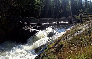
Wekusko Falls Provincial Park is a provincial park straddling the Grass River and Wekusko Lake, located in central Manitoba on Manitoba Provincial Road 392 near Snow Lake, Manitoba.
Grass River Provincial Park is a 2,279 km2 provincial park in Northwestern Manitoba, Canada. Designated in 1963, the park is approximately 75 km north of The Pas and is centered on the Grass River. The southern part of the park includes portions of the dolomitic Manitoba Lowlands portion of the Interior Plains, while the northern portion includes part of the granitic Canadian Shield. It it crossed east-west by Manitoba Highway 39, with PTH 10 crossing the western edge of the park. The entire park shows evidence of glaciation. The park is considered to be a Class III protected area under the IUCN protected area management categories.
The Porcupine Hills refer to various groups of hills and uplands located in the prairie provinces of Canada, specifically the provinces of Saskatchewan and Manitoba. They are part of the Manitoba Escarpment, which was the shoreline of the ancient glacial Lake Agassiz. The hills are located north-west of Swan River, Manitoba, and are the headwaters of the Swan River. The highest elevation in the Porcupine Hills is Hart Mountain, at an elevation of 823 metres (2,700 ft), which makes it Manitoba's second-highest point. The Porcupine Provincial Forest surrounds the area.
The Seal River is a river in the Northern Region of Manitoba, Canada. It travels 260 kilometres (160 mi) from Shethanei Lake to the Hudson Bay. The river was nominated for the Canadian Heritage Rivers System in 1987 and was officially listed in 1992. In January 2024, the Governments of Canada and Manitoba and Members of the Sayisi Dene First Nation, O-Pipon-Na-Piwin Cree Nation, Northlands Denesuline First Nation and Barren Lands First Nation reached an agreement to designate the watershed as an Indigenous and community conserved area.
The Rural Municipality of Ochre River is a former rural municipality (RM) in the Canadian province of Manitoba. It was originally incorporated as a rural municipality on November 18, 1901. It ceased on January 1, 2015 as a result of its provincially mandated amalgamation with the RM of Lawrence to form the Rural Municipality of Lakeshore.

Split Lake is a lake on the Nelson River in Manitoba, Canada. The settlement of Split Lake is located on a peninsula on the northern shore. The lake is about 46 km long.

The Cochrane River is a river in Canadian provinces of Manitoba and Saskatchewan. Located in the boreal forest of the Canadian Shield, it flows from Wellbelove Bay on the northern end of Wollaston Lake in north-eastern Saskatchewan to the north-east end of Reindeer Lake in Manitoba. The river has a drainage basin of 28,400 square kilometres (11,000 sq mi) and is part of the Churchill River drainage basin.
Rivers Provincial Park is a provincial park in the Canadian province of Manitoba, designated by the Government of Manitoba in 1961. The park is .86 square kilometres (0.33 sq mi) in size and is considered to be a Class III protected area under the IUCN protected area management categories.

