Enduleni is an administrative ward in the Ngorongoro District of the Arusha Region of Tanzania. The ward is home of the Laetoli prehistoric site. In 2016 the Tanzania National Bureau of Statistics report there were 13,537 people in the ward, from 13,537 in 2012.
Naiyobi is an administrative ward in the Ngorongoro District of the Arusha Region of Tanzania. In 2016 the Tanzania National Bureau of Statistics report there were 10,191 people in the ward, from 9,133 in 2012.
Makuyuni is an administrative ward in the Monduli district of the Arusha Region of Tanzania. In 2016 the Tanzania National Bureau of Statistics report there were 12,529 people in the ward, from 11,228 in 2012.
Madanga is an administrative ward in Pangani District of Tanga Region in Tanzania. The ward covers an area of 26.4 km2 (10.2 sq mi), and has an average elevation of 76 m (249 ft).

Gungu is an administrative ward in Kigoma-Ujiji District of Kigoma Region in Tanzania. The ward covers an area of 10.2 km2 (3.9 sq mi), and has an average elevation of 818 m (2,684 ft). In 2016 the Tanzania National Bureau of Statistics report there were 27,764 people in the ward, from 25,224 in 2012.

Kagera is an administrative ward in Kigoma-Ujiji District of Kigoma Region in Tanzania. The ward covers an area of 24.3 km2 (9.4 sq mi), and has an average elevation of 786 m (2,579 ft). In 2016 the Tanzania National Bureau of Statistics report there were 9,950 people in the ward, from 9,040 in 2012.

Kasingirima is an administrative ward in Kigoma-Ujiji District of Kigoma Region in Tanzania. The ward covers an area of 0.2 km2 (0.077 sq mi), and has an average elevation of 799 m (2,621 ft). In 2016 the Tanzania National Bureau of Statistics report there were 3,156 people in the ward, from 2,867 in 2012.

Kibirizi is an administrative ward in Kigoma-Ujiji District of Kigoma Region in Tanzania. The ward covers an area of 12.5 km2 (4.8 sq mi), and has an average elevation of 826 m (2,710 ft). In 2016 the Tanzania National Bureau of Statistics report there were 27,675 people in the ward, from 25,143 in 2012.
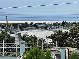
Kigoma is an administrative ward in Kigoma-Ujiji District of Kigoma Region in Tanzania. The ward covers an area of 4 km2 (1.5 sq mi), and has an average elevation of 789 m (2,589 ft). In 2016 the Tanzania National Bureau of Statistics report there were 7,604 people in the ward, from 6,908 in 2012.

Mwanga Kaskazini is an administrative ward in Kigoma-Ujiji District of Kigoma Region in Tanzania. The ward covers an area of 3.7 km2 (1.4 sq mi), and has an average elevation of 803 m (2,635 ft). In 2016 the Tanzania National Bureau of Statistics report there were 26,620 people in the ward, from 24,184 in 2012.

Rusimbi is an administrative ward in Kigoma-Ujiji District of Kigoma Region in Tanzania. The ward covers an area of 0.7 km2 (0.27 sq mi), and has an average elevation of 783 m (2,569 ft). In 2016 the Tanzania National Bureau of Statistics report there were 7,462 people in the ward, from 6,779 in 2012.
Buhanda is an administrative ward in Kigoma-Ujiji District of Kigoma Region in Tanzania. The ward covers an area of 5.5 km2 (2.1 sq mi), and has an average elevation of 864 m (2,835 ft). In 2016 the Tanzania National Bureau of Statistics report there were 8,397 people in the ward, from 7,629 in 2012.
Kasimbu is an administrative ward in Kigoma-Ujiji District of Kigoma Region in Tanzania. The ward covers an area of 1.9 km2 (0.73 sq mi), and has an average elevation of 783 m (2,569 ft). In 2016 the Tanzania National Bureau of Statistics report there were 5,405 people in the ward, from 4,910 in 2012.
Katubuka is an administrative ward in Kigoma-Ujiji District of Kigoma Region in Tanzania. The ward covers an area of 3 km2 (1.2 sq mi), and has an average elevation of 814 m (2,671 ft). In 2016 the Tanzania National Bureau of Statistics report there were 27,287 people in the ward, from 24,790 in 2012.
Kipampa is an administrative ward in Kigoma-Ujiji District of Kigoma Region in Tanzania. The ward covers an area of 1.8 km2 (0.69 sq mi), and has an average elevation of 777 m (2,549 ft). In 2016 the Tanzania National Bureau of Statistics report there were 8,714 people in the ward, from 7,917 in 2012.
Machinjioni is an administrative ward in Kigoma-Ujiji District of Kigoma Region in Tanzania. The ward covers an area of 1.1 km2 (0.42 sq mi), and has an average elevation of 839 m (2,753 ft). In 2016 the Tanzania National Bureau of Statistics report there were 3,814 people in the ward, from 3,465 in 2012.
Majengo is an administrative ward in Kigoma-Ujiji District of Kigoma Region in Tanzania. The ward covers an area of 1.1 km2 (0.42 sq mi), and has an average elevation of 784 m (2,572 ft). In 2016 the Tanzania National Bureau of Statistics report there were 4,765 people in the ward, from 4,329 in 2012.
Mwanga Kusini is an administrative ward in Kigoma-Ujiji District of Kigoma Region in Tanzania. The ward covers an area of 3.5 km2 (1.4 sq mi), and has an average elevation of 787 m (2,582 ft). In 2016 the Tanzania National Bureau of Statistics report there were 17,976 people in the ward, from 16,331 in 2012.
Rubuga is an administrative ward in Kigoma-Ujiji District of Kigoma Region in Tanzania. The ward covers an area of 1.2 km2 (0.46 sq mi), and has an average elevation of 784 m (2,572 ft). In 2016 the Tanzania National Bureau of Statistics report there were 2,899 people in the ward, from 2,634 in 2012.
Simbo is an administrative ward in Kigoma Rural District of Kigoma Region in Tanzania. Prior to 2014 the ward was in the Uvinza District before moving to the Kigoma District.
