
Namibia, officially the Republic of Namibia, is a country in Southern Africa. Its western border is the Atlantic Ocean. It shares land borders with Angola and Zambia to the north, Botswana to the east and South Africa to the east and south. Although it does not border Zimbabwe, less than 200 metres of the Botswanan right bank of the Zambezi River separates the two countries. Its capital and largest city is Windhoek.

Walvis Bay is a city in Namibia and the name of the bay on which it lies. It is the second largest city in Namibia and the largest coastal city in the country. The city covers an area of 29 square kilometres (11 sq mi) of land. The bay is a safe haven for sea vessels because of its natural deep-water harbour, protected by the Pelican Point sand spit, being the only natural harbour of any size along the country's coast. Being rich in plankton and marine life, these waters also draw large numbers of southern right whales, attracting whalers and fishing vessels.

Windhoek is the capital and largest city of Namibia. It is located in central Namibia in the Khomas Highland plateau area, at around 1,700 m (5,600 ft) above sea level, almost exactly at the country's geographical centre. The population of Windhoek, which was 486,169 in 2023, is constantly growing due to a continued migration from other regions in Namibia.

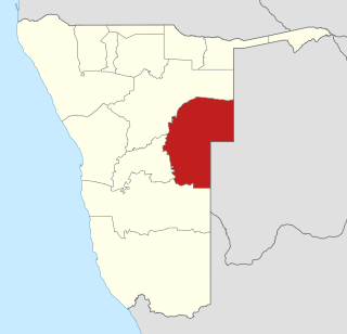
The Zambezi Region is one of the 14 regions of Namibia. It is located in the north-eastern part of the country. It is largely concurrent with the major Zambezi River after which it was named. The region has eight constituencies and its capital is the town of Katima Mulilo. The self-governed village of Bukalo is also situated in this region. The Zambezi Region had a population of 90,596 in 2011. As of 2020, it had 47,884 registered voters. At the time of the 2023 census, 142,373 people lived in the region.

Hardap is one of the fourteen regions of Namibia, its capital is Mariental. Hardap contains the municipality of Mariental, the towns Rehoboth and Aranos, and the self-governed villages Gibeon, Gochas, Kalkrand, Stampriet and Maltahöhe. It is home to the Hardap Dam.

The ǁKaras Region is the southernmost, largest, and least densely populated of the 14 regions of Namibia; its capital is Keetmanshoop. The name assigned to the region reflects the prominence of the Karas mountain range in its southern part. The ǁKaras region contains the municipality of Keetmanshoop, the towns Karasburg, Lüderitz and Oranjemund, and the self-governed villages Aroab, Berseba, Bethanie, Koës and Tses.

Khomas is one of the fourteen regions of Namibia. Its name refers to the Khomas Highland, a high plateau landscape that dominates this administrative subdivision. Khomas is centered on the capital city Windhoek and provides for this reason superior transportation infrastructure. It is located in the central highlands of the country and is bordered by the Erongo region to the west and the northwest and by the Otjozondjupa region to the north. To the east is the Omaheke region, while in the south is the Hardap region. The region is characterized by its hilly countrysize and many valleys. It has well-developed economical, financial, and trade sectors. Khomas Region occupies 4.5% of the land area of Namibia but has the highest population of any of its regions (16.2%). Khomas is one of only three Namibian regions to have neither shoreline nor a foreign border.

Omusati is one of the fourteen regions of Namibia, its capital is Outapi. The towns of Okahao, Oshikuku and Ruacana as well as the self-governed village Tsandi are situated in this region. As of 2020, Omusati had 148,834 registered voters.
Omaheke is one of the fourteen regions of Namibia, the least populous region. Its capital is Gobabis. It lies in eastern Namibia on the border with Botswana and is the western extension of the Kalahari desert. The self-governed villages of Otjinene, Leonardville and Witvlei are situated in the region. As of 2020, Omaheke had 48,594 registered voters.

Ohangwena is one of the fourteen regions of Namibia, its capital is Eenhana. Major settlements in the region are the towns Eenhana and Helao Nafidi as well as the self-governed village of Okongo and the proclaimed settlements Ongenga and Omungwelume. As of 2020, Ohangwena had 150,724 registered voters.

Kunene is one of the fourteen regions of Namibia. Its capital is Opuwo, its governor is Marius Sheya. The region's name comes from the Kunene River which forms the northern border with Angola. Besides the capital Opuwo, the region contains the municipality of Outjo, the town Khorixas and the self-governed village Kamanjab. Kunene is home to the Himba people, a subtribe of the Herero, as well as to Damara people and Nama people. As of 2020, Kunene had 58,548 registered voters.

Swakopmund, is a city on the coast of western Namibia, 352 km (219 mi) west of the Namibian capital Windhoek via the B2 main road. It is the capital of the Erongo administrative district. As of 2011, the town had 44,725 inhabitants and 196 km2 (76 sq mi) of land. In 2023, the population had increased to 75,921 people.

Herero (Otjiherero) is a Bantu language spoken by the Herero and Mbanderu peoples in Namibia and Botswana, as well as by small communities of people in southwestern Angola. There were 250,000 speakers in these countries between 2015 and 2018.

Katima Mulilo or simply Katima is the capital of the Zambezi Region in Namibia. It had 46,401 inhabitants in 2023, and comprises two electoral constituencies, Katima Mulilo Rural and Katima Mulilo Urban. It is located on the B8 national road on the banks of the Zambezi River in the Caprivi Strip in lush riverine vegetation with tropical birds and monkeys. The town receives annual average rainfall of 654 millimetres (25.7 in).

The North-West District or Ngamiland is one of the first-level administrative subdivisions of Botswana. For census and administrative purposes Ngamiland is subdivided into Ngamiland East, Ngamiland West and Ngamiland Delta (Okavango). It is governed by a District Commissioner, appointed by the national government, and the elected North-West District Council. The administrative centre is Maun.

Rundu is the capital and largest city of the Kavango-East Region in northern Namibia. It lies on the border with Angola on the banks of the Kavango River about 1,000 metres above sea level. Rundu's population is growing rapidly. The 2001 census counted 36,964 inhabitants; and for the 2011 census it has climbed to 63,430.
Kalkfeld is a settlement in the Otjozondjupa Region of Namibia. It is situated halfway between Omaruru and Otjiwarongo on the national road C33 and belongs to the Omatako electoral constituency. The place normally receives an annual average rainfall of 346 millimetres (13.6 in), although in the 2010/2011 rainy season 858 millimetres (33.8 in) were measured. Due to its location in former Damaraland, the majority of the inhabitants speak Khoekhoegowab or Otjiherero.

Stampriet is a village in Hardap Region, Namibia. It is located 64 km north-east of Mariental and 1,177 metres (3,862 ft) above sea level, in a barren area on the upper reaches of the Auob River where humans and animals alike depend on borehole water. Stampriet is the administrative center of the Mariental Rural electoral constituency.
Okongo is a village in the Ohangwena Region of northern Namibia. It is situated about 120 kilometres (75 mi) east of Eenhana on the tarred road to Nkurenkuru. It is the district capital of Okongo Constituency.
Oshigambo is a settlement in the Oshikoto Region of northern Namibia. It is situated on the banks of Oshigambo River east of the Etosha pan.
