Timeline and graph of related authorities

The Shire of Boulder was a local government area in Western Australia. It was established as the East Coolgardie Road District on 15 February 1895. It was renamed the Kalgoorlie Road District on 24 September 1897. [1] The board's offices were located at 39 Porter Street, Kalgoorlie; the building survives today and has been classified by the National Trust of Australia. [2]
It expanded significantly over subsequent decades as it absorbed abolished road districts in the region, absorbing the Bulong Road District on 9 June 1911, the Broad Arrow Road District on 7 July 1922 and the Kanowna Road District on 15 September 1922. [3] [4] [5] [1]
It was declared a shire and named the Shire of Kalgoorlie with effect from 1 July 1961 following the passage of the Local Government Act 1960, which reformed all remaining road districts into shires. [6] The membership of the council increased from 9 members to 11 members on 9 December 1966. On 1 July 1969, it absorbed the abolished Town of Boulder, expanding to include an urban area for the first time. It was then renamed the Shire of Boulder on 12 December 1969. [1]
It was divided into wards (three wards of three members and two wards of two members) on 9 December 1977. The Central Ward was increased from three to four members and the Pastoral Ward decreased from two to one member on 22 January 1988. [1]
It amalgamated with the Town of Kalgoorlie to form the City of Kalgoorlie-Boulder on 1 February 1989. [1]
The following people served as chairman of the Kalgoorlie Roads Board or president of the Shire of Kalgoorlie/Shire of Boulder: [7]

Kanowna is a ghost town in the Goldfields region of Western Australia, about 20 kilometres (12 mi) east of Kalgoorlie. It is sited on Maduwongga tribal lands. At the 2016 census, Kanowna had a population of 10 people.

North-East Coolgardie was an electoral district of the Legislative Assembly in the Australian state of Western Australia from 1897 to 1901.
The Goldfields Football League is an Australian rules football league based in the Goldfields region of Western Australia. Founded in 1896 as Hannans District Football Association, the league enjoyed a seat and full voting rights on the Australian National Football Council until 1919. The first clubs to play Australian football were formed within the region, and the league helped popularise the sport in the region, helping to establish the sport and supplant Rugby in popularity. The GFL was known as the Goldfields Football Association (GFA) from 1901–07 and 1920–25, and as the Goldfields National Football League (GNFL) from 1926–87.
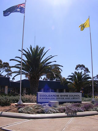
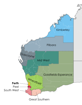
The Shire of Coolgardie is a local government area in the Goldfields–Esperance region of Western Australia, lying roughly west and south of the city of Kalgoorlie. The Shire covers an area of 30,400 square kilometres (11,738 sq mi), and its seat of government is the town of Coolgardie, although the twin towns of Kambalda East and Kambalda West contain two-thirds of the Shire's population.

The Shire of Beverley is a local government area in the Wheatbelt region of Western Australia about 130 kilometres (80 mi) southeast of Perth, the state capital. The Shire covers an area of 2,372 square kilometres (916 sq mi), starting 20 kilometres (12 mi) outside Armadale in the Darling Scarp and extending eastwards beyond the scarp into agricultural lands which support broad acre activities such as livestock and cropping. Its seat of government is the town of Beverley, which accommodates just over half of the Shire's population.

The City of Kalgoorlie–Boulder is a local government area in the Goldfields–Esperance region of Western Australia, about 550 kilometres (342 mi) east of the state capital, Perth. Covering an area of 95,575 square kilometres (36,902 sq mi), the city is the 12th largest in the world, larger than the country of Portugal with a land area of 92,212 square kilometres (35,603 sq mi). Its seat of government is the town of Kalgoorlie; all but 244 of the city's population live in either Kalgoorlie or Boulder.

The Shire of Leonora is a local government area in the Goldfields-Esperance region of Western Australia, about 240 kilometres (149 mi) north of the city of Kalgoorlie and about 830 kilometres (516 mi) northeast of the state capital, Perth. The Shire covers an area of 32,189 square kilometres (12,428 sq mi), and its seat of government is the town of Leonora.

The Shire of Menzies is a local government area in the Goldfields-Esperance region of Western Australia, located to the north of Kalgoorlie. It covers an area of 124,635 square kilometres (48,122 sq mi), and its seat of government is the town of Menzies.
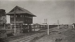
Kalgoorlie railway station is the easternmost attended station in Western Australia, located at the eastern terminus of the Eastern Goldfields Railway. It serves the city of Kalgoorlie. Beyond Kalgoorlie, the line continues east as the Trans-Australian Railway.
Eyre was an electoral district of the Legislative Assembly of Western Australia. It was in existence for three separate periods, on each occasion covering large portions of south-eastern Western Australia. Eyre was a safe seat for the Labor Party in its first two incarnations, but during its third incarnation was a marginal seat between the Liberal Party and the National Party.

East Coolgardie was an electoral district of the Legislative Assembly in the Australian state of Western Australia from 1897 to 1901.

Robert Hastie was an Australian politician who was the first parliamentary leader of the Labour Party in Western Australia. He was a member of the state's Legislative Assembly from 1901 to 1905.
This is a list of newspapers published in, or for, the Goldfields–Esperance region of Western Australia.
George James Lambert was an Australian politician who was a Labor Party member of the Legislative Assembly of Western Australia from 1916 to 1930 and again from 1933 until his death. He worked as a metallurgist before entering politics.
David Peter Dellar was an Australian politician who served as a Labor Party member of the Legislative Council of Western Australia from 1963 to 1965, representing North-East Province.
The Broad Arrow Road District was an early form of local government area on the Western Australian goldfields. It was established on 15 December 1899, providing basic local government to the rural areas around the mining town of Broad Arrow, which had already been incorporated as the Municipality of Broad Arrow in 1897. The board's office was located in Broad Arrow township.
The Bulong Road District was an early form of local government area on the Western Australian goldfields. It was formally established on 20 December 1899, providing a basic form of local government to the rural areas around the mining town of Bulong, which had already incorporated as the Municipality of Bulong in 1896. However, it took several months before the road board had practically established itself, and in March 1900 the Kalgoorlie Sun wrote: "...a roads board has been gazetted for Bulong, all on its own. But now they have their roads board, they don't know what to do with it." The first road board election took place on 3 April 1900. The road board met at the municipality's office, the council chambers, in Bulong township.
The Municipality of Coolgardie was a local government area in Western Australia, centred on the town of Coolgardie.
The Kanowna Road District was an early form of local government area on the Western Australian goldfields.
The North Coolgardie Road District was an early form of local government area on the Western Australian goldfields. It was based in the town of Menzies, although that township was outside the board's boundaries, having been incorporated as the Municipality of Menzies in 1895.
{{cite web}}: CS1 maint: archived copy as title (link)