Pike County is a county located in the U.S. state of Pennsylvania. As of the 2010 census, the population was 57,369. Its county seat is Milford.

Monroe County is a county in the U.S. state of Pennsylvania. As of the 2010 census, the population was 169,842. Its county seat is Stroudsburg. The county was formed from sections of Northampton and Pike counties. Named in honor of James Monroe, the fifth president of the United States, the county is located in northeastern Pennsylvania, along its border with New Jersey. Monroe County is coterminous with the East Stroudsburg, PA Metropolitan Statistical Area, within the Greater New York–Newark, NY–NJ–CT–PA Combined Statistical Area. It also borders the Lehigh Valley and has connections to the Delaware Valley, being a part of Philadelphia's Designated Media Market.

Mount Pocono is a borough in Monroe County, Pennsylvania, in the United States. It is located nearly centered in the southernmost county of five in the northeast corner that are part of the Poconos Mountains region of the state. The borough serves as a local highway nexus, and sees a lot of tourist traffic making use of resources in the region.

Shohola Township is a township in Pike County, Pennsylvania, United States. The population was 2,088 at the 2000 census.
Red Clay Creek is a 13.6-mile-long (21.9 km) tributary of White Clay Creek, running through southeastern Pennsylvania and northern Delaware in the United States. As of 2000, portions of the creek are under wildlife habitat protection.
Dingmans Ferry is an unincorporated community in Delaware Township, Pike County, Pennsylvania, United States. As of 2014, it had a population of 7,477 people. It was originally sited on the Delaware River, in an area now included in the Delaware Water Gap National Recreation Area. When the Corps of Engineers acquired the land by eminent domain in the mid-twentieth century for the creation of the proposed Tocks Island Dam project, it relocated the community further up the hill.
Bear Creek is a 17.1-mile-long (27.5 km) tributary of the Lehigh River in the Poconos of eastern Pennsylvania in the United States, joining the Lehigh at Francis E. Walter Reservoir.

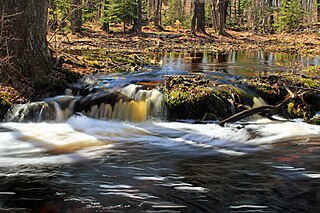
Brodhead Creek is a 21.9-mile-long (35.2 km) tributary of the Delaware River in the Poconos of eastern Pennsylvania in the United States.
Big Bushkill Creek is a 30.1-mile-long (48.4 km) tributary of the Delaware River in the Poconos of eastern Pennsylvania in the United States.
Middle Creek is a 20.7-mile-long (33.3 km) tributary of the Lackawaxen River in the Poconos of eastern Pennsylvania in the United States.

Pennsylvania Route 434 is a 12.47-mile-long (20.07 km) state highway located in northeast Pennsylvania. The western terminus of the route is at Pennsylvania Route 739 in the Blooming Grove Township community of Lords Valley. The eastern terminus of the route is at the New York-Pennsylvania border in Shohola Township, where PA 434 crosses the Delaware River and enters New York, becoming New York State Route 55 at an intersection with New York State Route 97 in the town of Highland. State Route 434 used to be part of Pennsylvania Route 37 and Pennsylvania Route 137.
Paradise Creek is a 9.6-mile-long (15.4 km) tributary of Brodhead Creek in the Poconos of eastern Pennsylvania in the United States.
Elk Creek is an 11.4-mile-long (18.3 km) tributary of Loyalsock Creek in Sullivan County, Pennsylvania in the United States.

Tunkhannock Creek is a 19.2-mile-long (30.9 km) tributary of Tobyhanna Creek in the Poconos of eastern Pennsylvania in the United States.
Tobyhanna Creek is a 29.9-mile-long (48.1 km) tributary of the Lehigh River in the Pocono Mountains of eastern Pennsylvania in the United States.
Wallenpaupack Creek is a 30.0-mile-long (48.3 km) tributary of the Lackawaxen River in the Pocono Mountains of eastern Pennsylvania in the United States.

The Barryville–Shohola Bridge is the fifth generation of bridges constructed over the Delaware River at the communities of Shohola Township, Pennsylvania and Barryville, New York. The bridge serves both communities, with two major state legislative highways, Pennsylvania Traffic Route 434 and New York State Touring Route 55. The bridge itself is 812 feet (247 m) long and is 23 feet (7.0 m) wide, using four total spans across the river. It is maintained by the NY–PA Joint Interstate Bridge Commission, which is jointly owned by the states of New York and Pennsylvania.
The Great Shohola train wreck occurred on July 15, 1864 during the American Civil War on the broad gauge Erie Railroad 11⁄2 miles (2.4 km) west of Shohola, Pennsylvania, killing at least 60 people. Aboard the 18 car train were 833 Confederate prisoners of war and 128 Union guards from the Veteran Reserve Corps. The prisoners were being taken from Point Lookout, Maryland to newly constructed Camp Rathbun at Elmira, New York, built to house 10,000 inmates. They had begun their journey by steamer, traveling along the Atlantic coast from Maryland to New Jersey. Here they were switched to railroad for the final 273 miles (439 km) to Elmira.

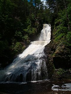
Raymondskill Falls is a series of three cascading waterfalls located on Raymondskill Creek, Pennsylvania, United States near several other waterfalls in the area including Dingmans Falls, Bushkill Falls, and Shohola Falls. The three tiers of Raymondskill Falls have a combined height of approximately 150 feet/46 meters. It is the tallest waterfalls in the state. It is part of the Delaware Water Gap National Recreation Area.