
Ferns is a historic town in north County Wexford, Ireland. It is 11.7 km (7.3 mi) from Enniscorthy, where the Gorey to Enniscorthy R772 road joins the R745, both regional roads. The remains of Ferns Castle are in the centre of the town.

Kinvara or Kinvarra is a sea port village in the southwest of County Galway, Ireland. It is located in the civil parish of Kinvarradoorus in the north of the barony of Kiltartan. Kinvarra is also an electoral division.

Graiguenamanagh or Graignamanagh is a town on the River Barrow in County Kilkenny, Ireland. Part of the settlement, known as Tinnahinch, is on the County Carlow side of the river, and Carlow County Council refers to the whole village as "Graiguenamanagh-Tinnahinch". Also combined for census purposes, as of the 2016 census, Graiguenamanagh-Tinnahinch had a population of 1,475 people.

Cloyne is a small town to the southeast of Midleton in eastern County Cork. It is also a see city of the Anglican Diocese of Cork, Cloyne and Ross, while also giving its name to a Roman Catholic diocese. St Colman's Cathedral in Cloyne is a cathedral church of the Church of Ireland while the Pro Cathedral of the Roman Catholic Diocese of Cloyne, Cobh Cathedral of Saint Colman, overlooks Cork Harbour. Cloyne is within the Cork East Dáil constituency.
Castleknock is an affluent suburb located 8 km (5 mi) west of the centre of Dublin city, Ireland. It is centred on the village of the same name in Fingal.

Aughagower or Aghagower is a small village in rural County Mayo in western Ireland. It is located about 6 km from Westport. Aughagower has around 40 houses, 1 pub and a shop, with a clear view of Croagh Patrick from Reek View. It also forms the centre of a parish of the same name which covers an area of 86.1 square miles. The village is known for its links to Saint Patrick and Tóchar Phádraig, the pilgrimage route from Ballintubber Abbey to Croagh Patrick.

Knowth is a Neolithic passage grave and an ancient monument of the World Heritage Site of Brú na Bóinne located 8.4 km west of Drogheda in Ireland's valley of the River Boyne. It is the largest passage grave of the Brú na Bóinne complex. It consists of a large mound and 17 smaller satellite tombs. The mound is about 12 metres (40 ft) high and 67 metres (220 ft) in diameter, covering roughly a hectare. It contains two passages placed along an east-west line and is encircled by 127 kerbstones, of which three are missing, and four badly damaged.

Kilmaine or Kilmain is a barony and village in County Mayo, Ireland.
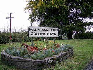
Collinstown is a village in north County Westmeath, situated on the R395 regional road overlooking Lough Lene. It lies 18 km (11 mi) northeast of the county town of Mullingar and had a population of 356.

The Archdiocese of Tuam is an ecclesiastical territory or archdiocese of the Catholic Church located in western Ireland. The archdiocese is led by the Archbishop of Tuam, who serves as pastor of the mother church, the Cathedral of the Assumption and Metropolitan of the Metropolitan Province of Tuam. According to tradition, the "Diocese of Tuam" was established in the 6th century by St. Jarlath. The ecclesiastical province, roughly co-extensive with the secular province of Connacht, was created in 1152 by the Synod of Kells.

Rahan is a parish and village in County Offaly, Ireland. It is associated with Mochuda. The village is located on the banks of the river Clodagh approximately 8 km from Tullamore. The parish of Rahan extends from The Island near Ballycumber in the north to Mucklagh in the south.

The Bishop of Ossory is an episcopal title which takes its name after the ancient of Kingdom of Ossory in the Province of Leinster, Ireland. In the Roman Catholic Church it remains a separate title, but in the Church of Ireland it has been united with other bishoprics.
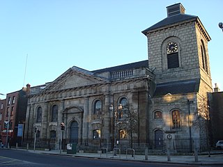
St. Catherine's Church, on Thomas Street, in Dublin, Ireland, was originally built in 1185. It is located on what was once termed the "Slí Mhór", a key route that ran westwards across Ireland from Dublin. The church was rebuilt in its present form in the 18th century by John Smyth.
Oughtmama is a civil parish in County Clare. It lies in the Burren, a region in the northwest of the county. It contains many antiquities, including three early-medieval Christian churches, ruined castles, prehistoric cairns and ring forts and two Martello Towers built in the early 19th century.
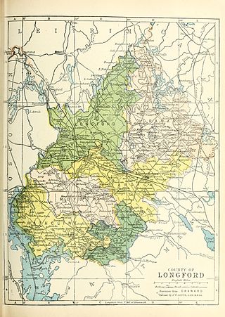
Shrule, sometimes called Abbeyshrule, is a barony in County Longford, Ireland.

Drumacoo is a medieval ecclesiastical site and National Monument located in County Galway, Ireland.
The Conmhaícne Cúile or Conmaicne Cuile Tolad were an early people of Ireland. Their tuath comprised, at minimum, most of the barony of Kilmaine, in County Mayo.

Moyne is a townland in the parish of Shrule in County Mayo, Ireland. It is bordered by Cloghmoyne and Gortbrack townlands to the west, by Toorard, Barnaboy, and Ross, County Mayo to the east. To the south is county Galway. This boundary is formed by the Black River.

Killashee Round Tower is an Irish round tower that forms part of the monastic remnants of Killashee, County Kildare, Ireland. On the Record of Monuments and Places its number is KD024-003.

