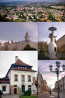
Gorlicepronounced [ɡɔrˈlʲit͡sɛ] is a city and an urban municipality ("gmina") in south eastern Poland with around 29,500 inhabitants (2008). It is situated south east of Kraków and south of Tarnów between Jasło and Nowy Sącz in the Lesser Poland Voivodeship, previously in Nowy Sącz Voivodeship (1975–1998). It is the capital of Gorlice County.

Sękowa is a historic village in southern Poland first incorporated by an edict issued on February 22, 1363, by King Kazimierz Wielki.

Półrole is a village in the administrative district of Gmina Biecz, within Gorlice County, Lesser Poland Voivodeship, in southern Poland. It lies approximately 4 kilometres (2 mi) south-west of Biecz, 8 km (5 mi) north-east of Gorlice, and 102 km (63 mi) south-east of the regional capital Kraków.

Bartne is a village in the administrative district of Gmina Sękowa, within Gorlice County, Lesser Poland Voivodeship, in southern Poland, close to the border with Slovakia. It lies approximately 11 kilometres (7 mi) east of Sękowa, 16 km (10 mi) south-east of Gorlice, and 115 km (71 mi) south-east of the regional capital Kraków.
Bodaki is a village in the administrative district of Gmina Sękowa, within Gorlice County, Lesser Poland Voivodeship, in southern Poland, close to the border with Slovakia. It lies approximately 8 kilometres (5 mi) east of Sękowa, 13 km (8 mi) south-east of Gorlice, and 112 km (70 mi) south-east of the regional capital Kraków.
Czarne is a village in the administrative district of Gmina Sękowa, within Gorlice County, Lesser Poland Voivodeship, in southern Poland, close to the border with Slovakia. It lies approximately 17 kilometres (11 mi) south-east of Sękowa, 23 km (14 mi) south-east of Gorlice, and 121 km (75 mi) south-east of the regional capital Kraków.
Jasionka is a village in the administrative district of Gmina Sękowa, within Gorlice County, Lesser Poland Voivodeship, in southern Poland, close to the border with Slovakia. It lies approximately 14 kilometres (9 mi) south-east of Sękowa, 20 km (12 mi) south-east of Gorlice, and 118 km (73 mi) south-east of the regional capital Kraków.
Krzywa is a village in the administrative district of Gmina Sękowa, within Gorlice County, Lesser Poland Voivodeship, in southern Poland, close to the border with Slovakia. It lies approximately 12 kilometres (7 mi) south-east of Sękowa, 18 km (11 mi) south-east of Gorlice, and 116 km (72 mi) south-east of the regional capital Kraków.
Lipna is a village in the administrative district of Gmina Sękowa, within Gorlice County, Lesser Poland Voivodeship, in southern Poland, close to the border with Slovakia. It lies approximately 19 kilometres (12 mi) south-east of Sękowa, 25 km (16 mi) south-east of Gorlice, and 122 km (76 mi) south-east of the regional capital Kraków.
Małastów is a village in the administrative district of Gmina Sękowa, within Gorlice County, Lesser Poland Voivodeship, in southern Poland, close to the border with Slovakia. It lies approximately 6 kilometres (4 mi) south-east of Sękowa, 12 km (7 mi) south-east of Gorlice, and 110 km (68 mi) south-east of the regional capital Kraków.
Męcina Mała is a village in the administrative district of Gmina Sękowa, within Gorlice County, Lesser Poland Voivodeship, in southern Poland, close to the border with Slovakia. It lies approximately 4 kilometres (2 mi) north-east of Sękowa, 7 km (4 mi) south-east of Gorlice, and 106 km (66 mi) south-east of the regional capital Kraków.

Męcina Wielka is a village in the administrative district of Gmina Sękowa, within Gorlice County, Lesser Poland Voivodeship, in southern Poland, close to the border with Slovakia. It lies approximately 7 kilometres (4 mi) north-east of Sękowa, 8 km (5 mi) east of Gorlice, and 107 km (66 mi) south-east of the regional capital Kraków.
Nieznajowa is a depopulated village in the administrative district of Gmina Sękowa, within Gorlice County, Lesser Poland Voivodeship, in southern Poland, close to the border with Slovakia. It lies approximately 19 kilometres (12 mi) south-east of Sękowa, 24 km (15 mi) south-east of Gorlice, and 123 km (76 mi) south-east of the regional capital Kraków.

Owczary is a village in the administrative district of Gmina Sękowa, within Gorlice County, Lesser Poland Voivodeship, in southern Poland, close to the border with Slovakia. It lies approximately 3 kilometres (2 mi) south-west of Sękowa, 8 km (5 mi) south of Gorlice, and 104 km (65 mi) south-east of the regional capital Kraków.
Pętna is a village in the administrative district of Gmina Sękowa, within Gorlice County, Lesser Poland Voivodeship, in southern Poland, close to the border with Slovakia. It lies approximately 7 kilometres (4 mi) south-east of Sękowa, 12 km (7 mi) south-east of Gorlice, and 111 km (69 mi) south-east of the regional capital Kraków.
Radocyna is an uninhabited village in the administrative district of Gmina Sękowa, within Gorlice County, Lesser Poland Voivodeship, in southern Poland, close to the border with Slovakia. It lies approximately 20 kilometres (12 mi) south-east of Sękowa, 26 km (16 mi) south-east of Gorlice, and 124 km (77 mi) south-east of the regional capital Kraków.

Ropica Górna is a village in the administrative district of Gmina Sękowa, within Gorlice County, Lesser Poland Voivodeship, in southern Poland, close to the border with Slovakia. It lies approximately 4 kilometres (2 mi) east of Sękowa, 9 km (6 mi) south-east of Gorlice, and 108 km (67 mi) south-east of the regional capital Kraków.
Wapienne is a village in the administrative district of Gmina Sękowa, within Gorlice County, Lesser Poland Voivodeship, in southern Poland, close to the border with Slovakia. It lies approximately 8 kilometres (5 mi) north-east of Sękowa, 9 km (6 mi) east of Gorlice, and 108 km (67 mi) south-east of the regional capital Kraków.
Wołowiec is a village in the administrative district of Gmina Sękowa, within Gorlice County, Lesser Poland Voivodeship, in southern Poland, close to the border with Slovakia. It lies approximately 15 kilometres (9 mi) south-east of Sękowa, 20 km (12 mi) south-east of Gorlice, and 119 km (74 mi) south-east of the regional capital Kraków.


