Sicklesmere

Last updated

Sicklesmere
Suffolk UK location map.svg
Red pog.svg
Sicklesmere
Location within Suffolk
Shire county
Region
Country England
Sovereign state United Kingdom
Post town Bury St Edmunds
Postcode district IP30
List of places
UK
England
Suffolk
52°12′36″N0°44′53″E / 52.210°N 0.748°E / 52.210; 0.748

Sicklesmere is a village in Suffolk, England. Located on the A134 around a mile south of Bury St Edmunds, the village is divided between the civil parishes of Little and Great Whelnetham .

Contents

History

All spellings of the name until the seventeenth century are with -d-, starting with Sidulfes mere circa 1100. The purported 1272 spelling Sykolvesmere, in W. Rye, A Calendar of the Feet of Fines for Suffolk (1900) is an error by Rye; the manuscript of the fine in the National Archives actually has Sydolvesm[er]e. [1] The village is named after a mere or lake that used to be present near the River Lark, and the first element is the Old English personal name *Siduwulf, not a Norse name (Keith Briggs and Kelly Kilpatrick, A dictionary of Suffolk place-names, Nottingham: EPNS & SIAH 2016, page 122). In truth it is no more than a small cluster of properties besides the River Lark. Many of these are flint-built cottages.

A circular-shaped building known as the Toll House is located on the main road. In the days of coach travel there was a regular service between Norwich and London via Sudbury which ran four times a day through Sicklesmere. The village was also previously served by Welnetham railway station until the Beeching Axe.

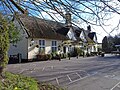
The village has a pub, the Rushbrooke Arms. [2]

Related Research Articles

<span class="mw-page-title-main">Culford</span> Village and civil parish in Suffolk, United Kingdom

Culford is a village and civil parish about 4 miles (6 km) north of Bury St Edmunds and 62 miles (100 km) north east of London in the West Suffolk district of Suffolk, England.

<span class="mw-page-title-main">Hawstead</span> Human settlement in England

Hawstead is a small village and civil parish in the West Suffolk district of Suffolk in eastern England. It is located 5 kilometres (3 mi) south of Bury St. Edmunds between the B1066 and A134 roads, in a fork formed by the River Lark and a small tributary.

<span class="mw-page-title-main">Grundisburgh</span> Human settlement in England

Grundisburgh is a village of 1,584 residents situated in the English county of Suffolk. It is in the East Suffolk district, six 6 miles (10 km) north-east from Ipswich and 4 miles (6 km) north-west of Woodbridge located on the B1079. Flowing through the village are the rivers Lark and Gull. The finding of Ipswich and Thetford-type pottery suggests that there was settlement in the Middle Saxon era. The village is recorded in the Domesday Book of 1086 as "Grundesbur", "Grundesburg", "Grundesburh" or "Grundesburc". Grundisburgh is pronounced "Gruns-bruh".

<span class="mw-page-title-main">Fressingfield</span> Human settlement in England

Fressingfield is a village in Suffolk, England, 12 miles (19 km) east of Diss, Norfolk. In 2015 it had a population of 1021, with one shop, a medical centre, public house, restaurant, primary school, and three churches, with Anglican, Baptist and Methodist congregations. A vineyard, Oak Hill Wines, is also located nearby.

<span class="mw-page-title-main">Northrepps</span> Human settlement in England

Northrepps is a village and a civil parish in the English county of Norfolk. It is 3.4 miles (5.5 km) southeast of Cromer, 22.2 miles (35.7 km) north of Norwich and 137 miles (220 km) north of London. The village lies west of the A149 which runs between Kings Lynn and Great Yarmouth. The nearest railway station is at Cromer for the Bittern Line which runs between Sheringham, Cromer and Norwich. The nearest airport is Norwich International Airport. The village and parish of Northrepps had in the 2001 census a population of 839, increasing to 886 at the 2011 Census. For the purposes of local government, the village falls within the district of North Norfolk.

<span class="mw-page-title-main">Icklingham</span> Human settlement in England

Icklingham is a village and civil parish in the West Suffolk district of Suffolk in eastern England. It is located about 7 miles (11 km) north-west of Bury St Edmunds, 4 miles (6.4 km) south-east of Mildenhall and 9 miles (14 km) south-west of Thetford in Norfolk. The village is on the A1101 road between Bury St Edmunds and Mildenhall in the north-west of the county. The area around the village, characterised by a sandy gravel-laden soil, is known as Breckland, though an arm of the fen-like peat follows the River Lark past the village.

<span class="mw-page-title-main">Great Bealings</span> Human settlement in England

Great Bealings is a small village in Suffolk, England. It has about 302 people living in it in around 113 households. Its nearest towns are Ipswich and Woodbridge. Nearby villages include Little Bealings, Playford, Culpho, Hasketon and Grundisburgh. The village does not have an obvious centre, and the population is split between two areas — one around Lower Street to the East of the village, and the other at Boot Street/Grundisburgh Road to the West of the village. St Mary's, the village church, is about in the middle of these two centres of population.

<span class="mw-page-title-main">Skeyton</span> Human settlement in England

Skeyton is a small village and civil parish in the English county of Norfolk. The village and parish of Skeyton had in the 2001 census a population of 200, increasing slightly to 207 at the 2011 census. For the purposes of local government, the parish falls within the district of North Norfolk. Skeyton lies 4 miles (6.4 km) east of the market town of Aylsham, 13.5 miles (21.7 km) south of Cromer, 13.4 miles (21.6 km) north of Norwich and 129 miles (208 km) north-east of London. The nearest railway station is at North Walsham for the Bittern Line which runs between Sheringham, Cromer and Norwich. The nearest airport is Norwich International Airport.

<span class="mw-page-title-main">Spixworth</span> Human settlement in England

Spixworth is a village and civil parish in the English county of Norfolk. The village lies close to the B1150 road and is 5 miles (8.0 km) north of Norwich and some 10 miles (16.1 km) south of North Walsham. It covers an area of 4.80 km2 (1.85 sq mi) and had a population of 3,769 in 1,508 households at the 2001 census. including Beeston St. Andrew but decreasing to a population of 3,718 in 1,579 households at the 2011 Census. For the purposes of local government, it falls within the district of Broadland.

<span class="mw-page-title-main">Thelnetham</span> Human settlement in England

Thelnetham is a village and civil parish in the West Suffolk district of Suffolk in eastern England. Located on the southern bank of the River Little Ouse, six miles west of Diss, in 2005 its population was 230. The village of Blo' Norton lies on the Norfolk side of the river. The name of the village derives from the Old English words "thel" which means a plank bridge, "elfitu" meaning swans and "hamm" meaning a meadow or enclosure. Hence the village is the "meadow with the plank bridge and the swans".

<span class="mw-page-title-main">Rushbrooke with Rougham</span> Human settlement in England

Rushbrooke with Rougham is a large civil parish in the West Suffolk district of Suffolk in eastern England covering the villages of Blackthorpe, Rougham and Rushbrooke as well as Rougham Airfield. Located directly south-east of Bury St Edmunds, in 2005 its population was 1,140. One 'Henry of Rushbrook' was Abbot of Bury St Edmunds from 1235 to 1248. The site of a former stately home, Rushbrooke Hall, is situated to the south of Rushbrooke. Until April 2019 it was in the St Edmundsbury district. The parish was created on 1 April 1988 from Rougham and parts of Great Barton, Great Whelnetham and Rushbrooke.

<span class="mw-page-title-main">Kennett, Cambridgeshire</span> Human settlement in England

Kennett is a small village and civil parish at the very eastern tip of Cambridgeshire, England. Situated around 2.5 miles (4.0 km) north-east of Newmarket and 4 miles (6.4 km) north-west of Bury St Edmunds, it falls into the county of Suffolk.

<span class="mw-page-title-main">Fornham St Genevieve</span> Human settlement in England

Fornham St Genevieve is a village and civil parish in the West Suffolk district of Suffolk in eastern England. It is one of a trio of contiguous villages by the River Lark. The other villages are Fornham All Saints and Fornham St Martin.

<span class="mw-page-title-main">Fornham St Martin</span> Human settlement in England

Fornham St Martin is a village and civil parish in the West Suffolk district of Suffolk in eastern England. Located on the northern outskirts of Bury St Edmunds off east and west from the A134, in 2005 its population was 1300. Its parish council is shared with neighbouring Fornham St Genevieve, and is known as Fornham St Martin cum St Genevieve Parish Council. Fornham St Martin is one of a trio of contiguous villages by the River Lark. The other villages are Fornham St Genevieve and Fornham All Saints.

<span class="mw-page-title-main">Thomas Jermyn, 2nd Baron Jermyn</span> English politician and peer

Thomas Jermyn, 2nd Baron Jermyn was an English politician who sat in the House of Commons from 1679 until he inherited a peerage in 1684.

<span class="mw-page-title-main">Stanningfield</span> Village in Suffolk, England

Stanningfield is a village and former civil parish, now in the parish of Bradfield Combust with Stanningfield, in the West Suffolk district of the county of Suffolk, England. The village lies just off of the A134 road, about 5 miles (8 km) south-east of Bury St Edmunds, 5 miles/8 km north-west of Lavenham, and 10 miles/16 km north of Sudbury. In 1961 the parish had a population of 211.

Sir Robert Jermyn DL (1539–1614) was a prominent East Anglian landowner and magistrate, of strongly reformist views in religion, who sat in the House of Commons at various times between 1584 and 1589.

<span class="mw-page-title-main">Rushbrooke Hall</span> British stately home in Suffolk

Rushbrooke Hall was a British stately home in Rushbrooke, Suffolk. For several hundred years it was the family seat of the Jermyn family. It was demolished in 1961.

<span class="mw-page-title-main">Rougham, Suffolk</span> Village in Suffolk, England

Rougham is a village and former civil parish 19 miles (31 km) north west of Ipswich, now in the parish of Rushbrooke with Rougham, in the West Suffolk district, in the county of Suffolk, England. Until April 2019 Rougham was in the St Edmundsbury district. In 1961 the parish had a population of 777. Rougham is also a ward, in 2011 the ward had a population of 2341. The ward touches Chadacre, Thurston, Rattlesden, The Fornhams & Great Barton, Moreton Hall, Lavenham, Horringer and Southgate. Rougham is pronounced "Ruff'm". In 1958 the parish had settlements at Mouse Lane estate, Rougham Green, Kingshall Street and Chapmans Close.

<span class="mw-page-title-main">Rushbrooke, West Suffolk</span> Village in Suffolk, England

Rushbrooke is a village and former civil parish on the River Lark, 20 miles (32 km) north west of Ipswich, now in the parish of Rushbrooke with Rougham, in the West Suffolk district, in the county of Suffolk, England. Until April 2019 Rushbrooke was in the St Edmundsbury district. In 1961 the parish had a population of 58.

References

  1. "CP25(1)215/32/11". Anglo American Law Tradition. 2015. Retrieved 6 February 2021.
  2. "Rushbrooke Arms". Eating Inn.

Commons-logo.svg Media related to Sicklesmere at Wikimedia Commons