
Huelva is a province of southern Spain, in the western part of the autonomous community of Andalusia. It is bordered by Portugal, the provinces of Badajoz, Seville, and Cádiz, and the Atlantic Ocean. Its capital is Huelva.

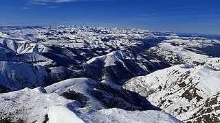
The Sierra Morena is one of the main systems of mountain ranges in Spain. It stretches for 450 kilometres from east to west across the south of the Iberian Peninsula, forming the southern border of the Meseta Central plateau and providing the watershed between the valleys of the Guadiana to the north and the west, and the Guadalquivir to the south.

Jamón is a type of dry-cured ham produced in Spain. It is one of the most globally recognized food items of Spanish cuisine. It is also regularly a component of tapas.
The Cantabrian Mountains or Cantabrian Range are one of the main systems of mountain ranges in Spain. They stretch for over 300 km (180 miles) across northern Spain, from the western limit of the Pyrenees to the Galician Massif in Galicia, along the coast of the Cantabrian Sea. Their easternmost end meets the Sistema Ibérico.
Galaroza is a town and municipality located in the Parque Natural de la Sierra de Aracena y Picos de Aroche, which is in the province of Huelva, Spain. According to the 2005 census, the city has a population of 1,642 inhabitants. In 2015 this figure decreased to 1,560.
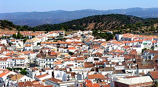
Aracena is a town and municipality located in the province of Huelva, southwestern Spain. As of 2012, the city has a population of 7,814 inhabitants. The town derived its name from the Sierra de Aracena, which is part of the Sierra Morena system.

Aroche is a municipality of Spain located in the province of Huelva, Andalusia. According to the 2005 census, the town had a population of 3,319.

The Sierra de Guadarrama is a mountain range forming the main eastern section of the Sistema Central, the system of mountain ranges along the centre of the Iberian Peninsula. It is located between the systems Sierra de Gredos in the province of Ávila, and Sierra de Ayllón in the province of Guadalajara.

Santa Olalla del Cala is a large village within the Autonomous region of Andalucia in southern Spain. The village is also a municipality located in the province of Huelva. the village is situated 1.1 miles (1.8 km) west of the A66-E803 motorway which runs from Sevilla to Salamanca. The village is 43.7 miles (70.3 km) north of the city of Sevilla and 40.9 miles (65.8 km) south of the town of Zafra. The village is 447.5 kilometres (278.1 mi) from the Spanish capital of Madrid and takes approximately 6 hours to travel from there by taxi. The nearest airport is Sevilla Airport which is 52.0 miles (83.7 km) to the south of the village. The nearest railway station is at Llerena which is 34.6 miles (55.7 km) north east of the village.
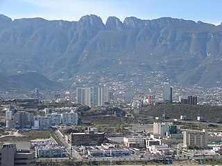
The Cerro de Chipinque is a mountain in the San Pedro Garza García, Monterrey and Santa Catarina municipalities; state of Nuevo León, Mexico. The mountain is part of the Sierra Madre Oriental range and the Cumbres de Monterrey National Park. The summit reaches 2,229 meters above sea level. The mountain is a symbol for the Monterrey metropolitan area. The mountain is surrounded by Santa Catarina valley, San Pedro valley, mount El Mirador, la Silla river, Ballesteros Canyon and La Huasteca canyon. The “Parque ecológico Chipinque” is on the north slope of the mountain. The mountain's name is believed to have originated from the Nahuatl word "chichipinqui" meaning small rain or from the name of an indigenous chief.

The Sierra de Francia is a mountain range located in Sierra de Francia Comarca at the southern end of Salamanca Province, Castile and León, Spain. It is located about 70 km from Salamanca city. The region is sparsely inhabited and its few towns have great cultural value.
Cumbres del Ajusco National Park is one of many national parks near Mexico City, DF. The Ajusco is known for its high elevations reaching 3,900 meters (12,795 ft) above sea level and is visible from any part of Mexico city. The park is characterized by pine-oak forests and high mountain grassland. Cumbres del Ajusco means "watered grove peaks", an appropriate name for this mountainous region covered with lush green forest with many flowers due to a fair amount of precipitation. The Balsas and Lerma rivers begin in the heart of the Cumbres del Ajusco.
Sierra Norte de Sevilla or Sierra Norte is one of the western mountain ranges of the Sierra Morena, Andalusia, Spain. Its name derives from its location at the northern part of Sevilla Province. The highest point of the range is the 960 m high Cerro de La Capitana.

Sierra de Aracena is the westernmost mountain range of the Sierra Morena, Andalusia, Spain. It is located in the northern part of Huelva Province.

The Sierra de Francia is a comarca located at the southern end of Salamanca Province, Castile and León, Spain. It is located about 70 km from Salamanca city. It borders with the Las Hurdes and Las Batuecas comarcas of Extremadura to the south; the Campo Charro to the north and the Sierra de Béjar to the east. The region is sparsely inhabited and its few towns have great cultural value.

Calblanque Regional Park, Monte de las Cenizas y Peña del Águila is a regional park in the south-east of Spain, and in this country in the autonomous community Región de Murcia. In this region, it is located in the municipalities Cartagena and La Unión. It is part of Sierra Minera, a mountain chain in the Baetic System.

Navachica is a mountain in the Province of Málaga in southern Spain, the highest peak in the Sierra Almijara.

The National Parks Autonomous Agency (OAPN) is an autonomous agency of the Spanish central government that manages the National Parks Network and the Spanish Biosphere Reserves Network, as well as mountains, farms and other patrimonial assets of its property. The agency was created on June 23, 1995 by the Agriculture Minister Luis María Atienza by merging two other agencies, the Institute for the Conservation of Nature (ICONA) and the National Institute for Agrarian Reform and Development (IRYDA).

The Sierra de Hornachuelos Natural Park is located to the west of the Province of Córdoba and has 60,032 hectares between the municipal borders of Almodóvar del Río, Córdoba, Hornachuelos, Posadas and Villaviciosa de Córdoba. It was declared a natural park on 28 July 1989.
