Sierra de Callosa | |
---|---|
Highest point | |
Elevation | 572 m (1,877 ft) |
Coordinates | 38°07′26″N0°53′46″W / 38.12389°N 0.89611°W Coordinates: 38°07′26″N0°53′46″W / 38.12389°N 0.89611°W |
Geography | |
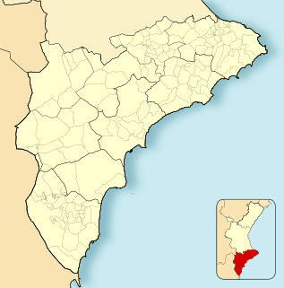
Location | Vega Baja del Segura, Valencian Community |
Parent range | Cordillera Prebética, Eastern zone |
Geology | |
Mountain type | karstic |
Climbing | |
Easiest route | From Callosa de Segura, Cox or Redován |
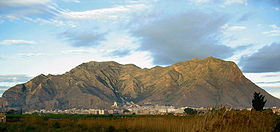
Sierra de Callosa (Valencian : Serra de Callosa) [1] is a 4.6 km (3 mi) long mountain range in the Vega Baja del Segura (Valencian : Baix Segura) comarca, Valencian Community, Spain. Its highest point is Águila (572 m). This range is named after the town of Callosa de Segura located at the feet of the mountains.
The Valencian Community is an autonomous community of Spain. It is the fourth most populous autonomous community after Andalusia, Catalonia and Madrid with more than 4.9 million inhabitants. Its homonymous capital Valencia is the third largest city and metropolitan area in Spain. It is located along the Mediterranean coast on the east side of the Iberian peninsula. It borders with Catalonia to the north, Aragon and Castilla–La Mancha to the west, and Murcia to the south. The Valencian Community consists of three provinces which are Castellón, Valencia and Alicante.
Spain, officially the Kingdom of Spain, is a country mostly located on the Iberian Peninsula in Europe. Its territory also includes two archipelagoes: the Canary Islands off the coast of Africa, and the Balearic Islands in the Mediterranean Sea. The African enclaves of Ceuta and Melilla make Spain the only European country to have a physical border with an African country (Morocco). Several small islands in the Alboran Sea are also part of Spanish territory. The country's mainland is bordered to the south and east by the Mediterranean Sea except for a small land boundary with Gibraltar; to the north and northeast by France, Andorra, and the Bay of Biscay; and to the west and northwest by Portugal and the Atlantic Ocean.
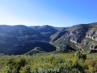
These conspicuous and harsh-looking massive limestone mountains rise abruptly from the low Segura River Valley floor and have some very steep cliffs. There is very little vegetation on the arid mountain slopes and both physically and geologically the Sierra de Callosa is similar to the Sierra de Orihuela range located only 2.6 km to the west. Smoother Sierra de Hurchillo is located 6.5 km to the south.
Limestone is a sedimentary rock which is often composed of the skeletal fragments of marine organisms such as coral, foraminifera, and molluscs. Its major materials are the minerals calcite and aragonite, which are different crystal forms of calcium carbonate (CaCO3).
Sierra de Orihuela is a 9.4 km (6 mi) long mountain range in the Vega Baja del Segura comarca, Valencian Community, Spain. Its highest point is Peña de Orihuela. This range is named after the town of Orihuela, located at the feet of the mountains. The western end of the range is within the limits of the Santomera municipal term, in the Region of Murcia.
These mountains were declared a Protected Area by the Generalitat Valenciana in 2005.
The Generalitat Valenciana is the generic name covering the different self-government institutions under which the Spanish autonomous community of Valencia is politically organized.
Alicante, or Alacant, is a province of eastern Spain, in the southern part of the Valencian Community. The second and third biggest cities in the Valencian Community are located in this province.
Orihuela is a city and municipality located at the feet of the Sierra de Orihuela mountains in the province of Alicante, Spain. The city of Orihuela had a population of 33,943 inhabitants at the beginning of 2013. The municipality has a total area of 367.19 km², and stretches all the way down to the Mediterranean coast, west of Torrevieja, and had a total population of 92,000 inhabitants at the beginning of 2013. This includes not only the city of Orihuela, but also the coastal tourist centre of Dehesa de Campoamor with 33,277 inhabitants (2013) and a few other villages.
Catral is a town in the Valencian Community, Spain. Located in the south of the province of Alicante, in the region of Vega Baja del Segura. It had 8,105 inhabitants in 2007 according to the National Statistics Institute of Spain.
La Vega Baja del Segura is a comarca in the province of Alicante, Valencian Community, Spain.
Benferri is a municipality in the comarca of Vega Baja del Segura in the Valencian Community, Spain.
Callosa de Segura is a municipality in the comarca of Vega Baja del Segura in the Valencian Community, Spain. It contains the historic monument of the Church of St Martin.
Cox is a municipality in the comarca of Vega Baja del Segura in the Valencian Community, Spain.
San Miguel de Salinas is a town and municipality in the Valencian Community (Spain), situated in the south of the province of Alicante; in the comarca of Vega Baja del Segura. In the 2006 census, the population was 7,104.
The Region of Murcia, is an autonomous community of Spain located in the southeast of the state, between Andalusia and Valencian Community, on the Mediterranean coast.
Sierra del Toro is a 21 km (13 mi) long mountain range in the Alt Palància comarca, Valencian Community, close to the limit with Teruel Province, Aragon, Spain. It is named after the nearby town of El Toro.
Sierra de Javalambre is a 29 km (18 mi) long mountain range in the Gúdar-Javalambre comarca of Aragon and the Rincón de Ademuz and Serrans comarcas of the Valencian Community, Spain.
Redován is a municipality in the comarca of Vega Baja del Segura in the Valencian Community, Spain.
Sierra del Mugrón is a 16.6 km (10 mi) long mountain range located between the Valle de Cofrentes comarca, Valencian Community, and Almansa, Castile-La Mancha, Spain. It is an isolated range between the Iberian System and the Cordillera Prebética. Its highest point is 1,209 m. The northern section of this range is within the Ayora municipal term, while the southern belongs to Almansa.
The Prebaetic System is a system of mountain ranges that forms the northeasternmost prolongation of the Baetic System in the southern Iberian Peninsula.
Serra d'Espadà is a 51 km (32 mi) long mountain range in the Alt Palància, Alt Millars and Plana Baixa comarcas, in the Province of Castellón, Valencian Community, Spain. Its highest point is La Ràpita.
Sierra de Enguera is a 16.45 km (10 mi) long mountain range in the Canal de Navarrés and Valle de Cofrentes comarcas, Valencian Community, Spain. Its highest point is Altos de Salomón in the Caroig Massif. Other important peaks are Palmera, Cova Negra and Marc.
Sierra de Utiel is a 16.45 km (10 mi) long mountain range in the Alt Palància, Alt Millars and Plana Baixa comarcas, Valencian Community, Spain. Its highest point is the 1,306 m high El Remedio. There is often snow in the winter.
Serra Calderona, often referred to as La Calderona is a 49 km (30 mi) long mountain range in the Camp de Túria, Horta Nord and Alt Palància comarcas of the Valencian Community, between the provinces of Castelló and Valencia Spain.
Serra de d'Esparreguera or Serra Esparreguera is an over 17 km (11 mi) long mountain range in the Alt Maestrat comarca, Valencian Community, Spain.
Wikimedia Commons has media related to Sierra de Callosa . |