Hanover is a town along the Connecticut River in Grafton County, New Hampshire, United States. The population was 11,260 at the 2010 census. CNN and Money magazine rated Hanover the sixth best place to live in America in 2011, and the second best in 2007. "This just might be the best college town," read the headline of a story in the January–February 2017 issue of Yankee.
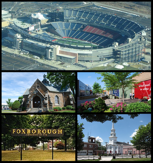
Foxborough is a town in Norfolk County, Massachusetts, United States, about 22 miles (35 km) southwest of Boston, 18 miles (29 km) northeast of Providence, Rhode Island and about 73 miles (117 km) northwest of Cape Cod. Foxborough is part of the Boston metropolitan statistical area. The population was 16,865 at the 2010 census.
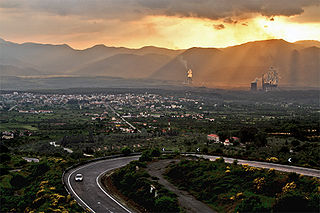
Megalopoli is a town in the southwestern part of the regional unit of Arcadia, southern Greece. It is located in the same site as ancient Megalopolis (Μεγαλόπολις). When it was founded in 371 BC, it was the first large urbanization in rustic Arcadia. Its theater had a capacity of 20,000 visitors, making it one of the largest ancient Greek theaters. Megalopoli has several schools, shops, churches, hotels and other services. The population of Megalopoli in 2011 was 5,779 for the town proper.

Banff is a town within Banff National Park in Alberta, Canada. It is located in Alberta's Rockies along the Trans-Canada Highway, approximately 126 km (78 mi) west of Calgary and 58 km (36 mi) east of Lake Louise. At 1,400 to 1,630 m above sea level, Banff is the community with the second highest elevation in Alberta, after Lake Louise.
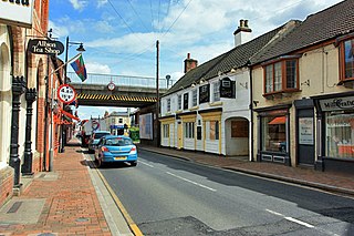
Market Rasen is a town and civil parish within the West Lindsey district of Lincolnshire, England. The River Rase runs through it east to west, approximately 13 miles (21 km) north-east from Lincoln, 18 miles (29 km) east from Gainsborough and 16 miles (26 km) south-west from Grimsby. The town is known for Market Rasen Racecourse and being close to the epicentre of a 2008 earthquake. The population of the civil parish at the 2011 census was 3,904.

Kanjirappally is a taluk and a town in Kottayam district situated about 38 km (24 mi) away from the district capital, in the state of Kerala, India. National Highway connects Kanjirapally to major nearest cities. Kanjirappally, also known as the Gateway of Highrange since it is the geographic entrance to the 'Malanad' or the Hill country of Kerala, which extends to Idukki district and then to Tamil Nadu. Kanjirapally is one of the most busiest towns in kottayam district. A new airport has been proposed which is near to kanjirapally in Erumeli.

Trikaripur or Elambachi is a village in Kasaragod District in the state of Kerala, India.

The National Capital Region (NCR) is a central planning region centred upon the National Capital Territory of Delhi in India. It encompasses the entire NCT of Delhi and several districts surrounding it from the states of Haryana, Uttar Pradesh and Rajasthan. The NCR and the associated National Capital Region Planning Board were created in 1985 to plan the development of the region and to evolve harmonized policies for the control of land-uses and development of infrastructure in the region. Prominent cities of NCR include Delhi, Gurgaon, Noida, Faridabad and Ghaziabad.

Palakkad pronunciation (help·info), also known as Palghat, is a city and municipality in the state of Kerala in southern India, spread over an area of 26.60 km2 and is the administrative headquarters of the Palakkad District. The city is situated about 350 kilometres (217 mi) north of state capital Thiruvananthapuram and 54 kilometers south west of Coimbatore, and 66 km north east of Thrissur on the Salem-Kanyakumari National Highway NH 47.

Gummudipoondi is an industrial town in Chennai Metropolitan Region of Thiruvallur district in the Indian state of Tamil Nadu.

Panoor is a Municipality in the district of Kannur in the state of Kerala, India. The town is the main market place for the farmer communities in the surrounding regions. Panoor is one of the fast upcoming towns in Kerala having an enormous scope of development and it is one of the main suburbs of Thalassery. Panoor got municipal status when the Government of Kerala recently decided to upgrade Panoor Grama Panchayat and added with other Panchayats, as Panoor Municipality along with formation of Kannur Municipal Corporation.

Tarakeswar is a town and a municipality in Hooghly district in the Indian state of West Bengal. It is also one of the police stations under Chandannagore subdivision. Tarakeswar is a place of pilgrimage and a centre of the Shaiva sect in West Bengal 58 kilometres (36 mi) away from Kolkata, Tarakeswar can be reached conveniently by train.

Maraimalai Nagar is a town of Kanchipuram District, near Chennai, Tamil Nadu, India. It is a municipality town in Kanchipuram district. It lies in the southern part of the Chennai metropolitan area around 50 km from downtown Chennai Egmore and about 15 km from Vandalur. Maraimalar Nagar is a part of the Chengalpattu taulk in Kanchipuram district. It is a satellite town developed by the CMDA in 1980. Many heavy industries are located in Maraimalai Nagar. The Ford India and BMW car factories are located within a mile from Maraimalai Nagar and the Indian software giant Infosys also has an office within eight kilometers of Maraimalai Nagar. SRM University has its main campus in the neighbouring Potheri. As of 2011, Maraimalai Nagar had a population of 81,872.

The A62 autoroute is a French motorway forming part of the Autoroute de Deux Mers. The entirety of the route forms the entirety of European route E 72, which is a part of the inter-European road system. The route of the A62 and E72 is between the cities of Bordeaux and Toulouse. The E72 was previously called E76 in 1975.

Harugeri is a town in Raybag taluk in Belagavi District of Karnataka state, India. The town name itself having a history, harigiri "Hari" and "Giri"(Sanddune) was the name before convened as Harugeri. According to some aldermen, it is called Halurukere from haluru (wreck) and kere (lakelet) before Ghataprabha Water Project; later on the town was developed by irrigation and overtook a major agricultural marketing and holds a record of economically strongest town in its taluka. It belongs to Belagavi division. It is located 100 km towards north from district headquarters Belagavi, 21 km from Raybag and 567 km from state capital Bangalore. It was upgraded as village panchayat to town municipal in 2015–16 as per 2011 census population. Before it was second largest Gram panchayat of India

Rozoy-Bellevalle is a commune in the Aisne department in Hauts-de-France in northern France. It is part of the canton of Essômes-sur-Marne and the arrondissement of Château-Thierry.
National Highway 44 is the longest-running major north–south National Highway in India. It begins from Srinagar and terminates in Kanyakumari; the highway passes through the states of Jammu & Kashmir, Punjab, Haryana, Delhi, Uttar Pradesh, Madhya Pradesh, Maharashtra, Telangana, Andhra Pradesh, Karnataka, and Tamil Nadu.
NH-44 was laid and is maintained by Central Public Works Department (CPWD).
Kabbur is a town in the southern state of Karnataka, India. It is located in the Chikodi taluk of Belgaum district in Karnataka.
Midakanatti (ಮಿಡಕನಟ್ಟಿ) is a small village in the Gokak Taluk and Belagavi District of Karnataka State in India. It is administered by the Midakanatti Panchayat. It is located 33 km east of the divisional headquarters in Belagavi, 18 km from the town of Gokak, and 452 km from the State capital, Bengaluru.