The East Coast Greenway is a 3,000-mile (4,800 km) biking and walking route linking the major cities of the Atlantic coast of the United States, from Calais, Maine, to Key West, Florida. The spine route and branching complementary routes are for non-motorized human transportation for everything from local commutes to long-distance trips.

The Minuteman Bikeway is a 10-mile (16-kilometre) paved multi-use rail trail located in the Greater Boston area of Massachusetts. It runs from Bedford to Alewife station, at the northern end of the Red Line in Cambridge, passing through the towns of Lexington and Arlington along the way. Also along the route are several notable regional sites, including Alewife Brook Reservation, Spy Pond, "Arlington’s Great Meadows", the Battle Green in Lexington, and Hanscom Air Force Base.
State Route 75 (SR 75) is a short, 13-mile (21 km) expressway in San Diego County, California. It is a loop route of Interstate 5 (I-5) that begins near Imperial Beach, heading west on Palm Avenue. The route continues north along the Silver Strand, a thin strip of land, through Silver Strand State Beach. SR 75 passes through the city of Coronado as Orange Avenue and continues onto the San Diego–Coronado Bay Bridge, which traverses the San Diego Bay, before joining back with I-5 near downtown San Diego at a freeway interchange.

The Arroyo Seco Bicycle Path is an approximately 2 miles (3.2 km) long Class I bicycle path along the Arroyo Seco river channel in the Northeast Los Angeles region of Los Angeles County, California. It parallels to the Arroyo Seco Parkway also in the canyon.

A bicycle boulevard, sometimes referred to as a neighborhood greenway, neighborway, neighborhood bikeway or neighborhood byway is a type of bikeway composed of a low-speed street which has been "optimized" for bicycle traffic. Bicycle boulevards discourage cut-through motor-vehicle traffic but allow local motor-vehicle traffic. They are designed to give priority to bicyclists as through-going traffic. They are intended as a low-cost, politically popular way to create a connected network of streets with good bicyclist comfort and/or safety.
The San Diego Creek bicycle path is the major bicycle backbone of the city of Irvine, California, which largely contains it. It connects major points such as Newport Beach, University of California, Irvine, Boomers, Colonel Bill Barber Park, Irvine Civic Center, The Crossroads Shopping Center, Woodbridge High School, Woodbridge Community Park, Atria Senior Residential Area, Windrow Community Park, Irvine Medical Complex, and ultimately, Irvine Spectrum Center. It also runs through the majority of Irvine's neighborhoods such as Westpark, Woodbridge, and Oak Creek. The path begins where the San Diego Creek empties into Upper Newport Bay. The Bay itself makes for a pleasant ride with a Class 2 bike lane on the Eastern shore along a quiet road, some busy streets in the South and a section of Class 1 path to the East.

The Hockhocking Adena Bikeway is a 21-mile (34 km) long bicycle path in Athens County, Ohio, in the United States. The original section of the path was built on a levee along the Hocking River at Ohio University in Athens, on university land. It was gradually expanded and now crosses university land, city land, and county land. The greater part of the path is a rail trail,. The eastern terminus of the path is near the intersection of East State Street with US-50 on the east side of Athens and its western terminus is in Nelsonville, at the Rocky Brands Factory Outlet at the intersection of Canal Street and Myers Street, one block from the Historic Square Arts District.
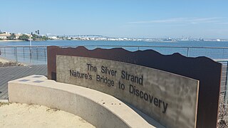
Silver Strand, or simply The Strand, is a low, narrow, sandy isthmus or tombolo 7 miles (11 km) long in San Diego County, California partially within the Silver Strand State Beach. It connects Coronado Island with Imperial Beach. Together with the Point Loma peninsula it shelters and defines San Diego Bay. State highway 75 runs the length of the strand and is a popular site for jogging and bicycling. The Silver Strand Half Marathon is run along the route each November.

The following is a list of transportation in San Diego County, California.

The Cape Cod Rail Trail (CCRT) is a 22-mile (35 km) paved rail trail located on Cape Cod in Massachusetts. The trail route passes through the towns of Dennis, Harwich, Brewster, Orleans, Eastham, and Wellfleet. It connects to the 6-plus mile (10 km) Old Colony Rail Trail leading to Chatham, and 8 miles (13 km) of trails within Nickerson State Park. It also passes near the end of the Nauset Bike Trail leading to Coast Guard Beach in Cape Cod National Seashore. Short side trips on roads lead to several other national seashore beaches.

California's transportation system is complex and dynamic. Although known for its car culture and extensive network of freeways and roads, the state also has a vast array of rail, sea, and air transport. Several subway, light rail, and commuter rail networks are found in many of the state's largest population centers. In addition, with the state's location on the West Coast of the United States, several important ports in California handle freight shipments from the Pacific Rim and beyond. A number of airports are also spread out across the state, ranging from small general aviation airports to large international hubs like Los Angeles International Airport and San Francisco International Airport.
In the San Diego area, the Mission Bay bike path is an easy, 3 mile one-way to 19 mile loop path along the shore of beautiful Mission Bay.
The San Luis Rey River bike path is a bike path, for bicycle and pedestrian use, that follows the San Luis Rey River in Oceanside, northern San Diego County, California.
Naval Base Coronado (NBC) is a consolidated Navy installation encompassing eight military facilities stretching from San Clemente Island, located seventy miles west of San Diego, California, to the Mountain Warfare Training Camp Michael Monsoor and Camp Morena, located sixty miles east of San Diego.
The Shoreline Pedestrian Bikepath also known as the Long Beach Bike Path is a 4.5-mile (7.2 km) path along the Pacific Ocean from Shoreline Village in downtown Long Beach, California to Belmont Shore, Los Angeles County. It was completed in 1988 and is used by walkers, joggers, and skaters. In 2013 the California Coastal Commission approved a second path for pedestrians to run parallel to the path used primarily by bicyclists.

The Island Line Trail is a 14-mile (23 km) rail trail located in northwest Vermont. It comprises the Burlington Bike Path (Burlington), Colchester Park (Colchester) and the Allen Point Access Area. The trail follows the route of the Island Line railroad, built by the Rutland Railroad in 1901. The history of the Rutland Railroad is covered in Robert C. Jones "Railroads of Vermont, Volume 2" (ISBN 9781881535027), and in James Shaughnessy's "The Rutland Railroad", Howell North Books 1964.


