Simmonston

Last updated

Simmonston
South Australia

Simmonston talex.jpg

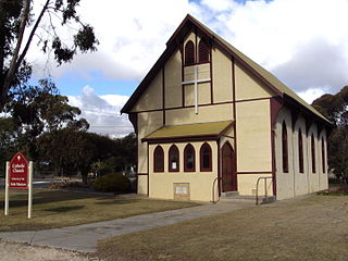
Ruins of the half-built hotel at Simmonston
Australia South Australia location map.svg
Red pog.svg
Simmonston
Coordinates 32°04′22″S138°09′08″E / 32.07289728°S 138.15227855°E / -32.07289728; 138.15227855 Coordinates: 32°04′22″S138°09′08″E / 32.07289728°S 138.15227855°E / -32.07289728; 138.15227855 [1]
Established 15 April 1880 [2]
LGA(s) Flinders Ranges Council

Simmonston was a former town in South Australia which was abandoned before completion in the early 1880s. The town was originally intended to be on the new railway extending north from Quorn, but the final route passed through Gordon instead. Today, the stone ruins of a hotel and its cellars are still visible. The town is reported as being "named after Sir Lintorn Simmons, Field Marshal and Commandant of the Royal Engineers" by William Jervois, the 10th Governor of South Australia. [3] The creation of the town was announced in April 1880 as follows: "Portions of Crown Lands in the Hundred of Kanyaka have been reserved as a site for the new town of Simmonston." [4] Plans to build the hotel were announced three weeks later in May 1880 by a D. McFie. [5] The site of the former town is currently located in the gazetted locality of Kanyaka and within the local government area of the Flinders Ranges Council. [1]

South Australia State of Australia

South Australia is a state in the southern central part of Australia. It covers some of the most arid parts of the country. With a total land area of 983,482 square kilometres (379,725 sq mi), it is the fourth-largest of Australia's states and territories by area, and fifth largest by population. It has a total of 1.7 million people, and its population is the second most highly centralised in Australia, after Western Australia, with more than 77 percent of South Australians living in the capital, Adelaide, or its environs. Other population centres in the state are relatively small; Mount Gambier, the second largest centre, has a population of less than 30,000.

Quorn, South Australia Town in South Australia

Quorn is a township and railhead in the Flinders Ranges in the north of South Australia, 39 km northeast of Port Augusta. At the 2016 census, the locality had a population of 1,230 of which 1,131 lived in its town centre.

Lintorn Simmons British Field Marshal

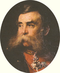
Field Marshal Sir John Lintorn Arabin Simmons was a British Army officer. Early in his career he served as Inspector of Railways, Secretary of the Railways Commission and then Secretary of the Railway Department under the Board of Trade. He went on to be British Commissioner with the Turkish Army providing advice to General Omar Pasha during the Crimean War. He assisted the Turks at the defence of Silistra and then led them at the Battle of Giurgevo before landing with them at the Battle of Eupatoria and remaining with them for the Siege of Sevastopol. After that he became British Consul in Warsaw, Commander, Royal Engineers at Aldershot and then Director of the Royal Engineer Establishment in Chatham. He went on to be Lieutenant-Governor of the Royal Military Academy and subsequently Governor of the Academy. His last appointments were as Colonel Commandant of the Royal Engineers, as Inspector General of Fortifications and then as Governor of Malta.

Related Research Articles

Mungindi Town in New South Wales, Australia

Mungindi is a town and locality on the border of New South Wales (NSW) and Queensland, Australia. The town is within Moree Plains Shire in New South Wales. Within Queensland, the locality is split between the Shire of Balonne and the Goondiwindi Region. It possesses a New South Wales postcode. Mungindi sits on the Carnarvon Highway and straddles the Barwon River which is the border between New South Wales and Queensland. At the 2016 census, Mungindi had a population of 601 on the New South Wales side. The population on the Queensland side had a population, including the surrounding area, of 146.

Terowie, South Australia Town in South Australia

Terowie is a small town in the mid-north of South Australia located 220 kilometres (137 mi) north of the state capital of Adelaide. It is located in the Regional Council of Goyder. Terowie retains a number of authentic and well preserved 1880s buildings, and has been declared a "historic town". It also remains a town of interest to those interested in rail history. Although now a very small town with few facilities, Terowie remains a popular destination for photographers, historians, and rail buffs. At the 2016 census, Terowie had a population of 131.

Morgan, South Australia Town in South Australia

Morgan is a town in South Australia on the right bank of the Murray River, just downstream of where it turns from flowing roughly westwards to roughly southwards. It is about 161 kilometres (100 mi) north east of Adelaide, and about 315 kilometres (196 mi) upstream of the Murray Mouth. At the 2006 census, Morgan had a population of 426.

Flinders Ranges Council Local government area in South Australia

Flinders Ranges Council is a local government area (LGA) located in the Flinders Ranges of South Australia.

Lameroo, South Australia Town in South Australia

Lameroo is a town in the Murray Mallee region of South Australia. It is on the Mallee Highway and Pinnaroo railway line about 40 km west of the Victorian border, or 210 km east of Adelaide. It is primarily a service town for the surrounding rural areas, growing grain and sheep. Lameroo now includes the former settlements of Kulkami, Mulpata, Wirha and Gurrai, which were on the Peebinga railway line, and Wilkawatt, which was between Parrakie and Lameroo on the Pinnaroo railway.

Marla, South Australia Town in South Australia

Marla is a town and locality in the Australian state of South Australia located in the state's north-west about 1,100 kilometres (680 mi) north-west of the state capital of Adelaide and about 402 kilometres (250 mi) south of the town of Alice Springs in the Northern Territory.

Kadina, South Australia Town in South Australia

Kadina is a town on the Yorke Peninsula of the Australian state of South Australia, approximately 144 kilometres north-northwest of the state capital of Adelaide. The largest town of the Peninsula, Kadina is one of the three Copper Triangle towns famous for their shared copper mining history. The three towns are known as "Little Cornwall" for the significant number of immigrants from Cornwall who worked at the mines in the late 19th century.

Mannahill, South Australia Town in South Australia

Mannahill is a settlement on the Barrier Highway and Indian Pacific railway line in South Australia. Mannahill is in the Northeast Pastoral district and is one of the easternmost settlements in South Australia. The population of Mannahill is 66 persons: 42 males and 24 females.

Point Bell Conservation Park Protected area in South Australia

Point Bell Conservation Park is a protected area in the Australian state of South Australia located in the gazetted locality of Penong in the west of the state on the coastline of the Great Australian Bight on land including and adjoining the headland of Point Bell about 52 kilometres west of the town of Ceduna.

District Council of Lefevres Peninsula Local government area in South Australia

The District Council of Lefevre's Peninsula was a local government area in South Australia centred on the Lefevre Peninsula from 1872 to 1884.

District Council of Wilmington Local government area in South Australia

The District Council of Wilmington was a local government area in South Australia, centred on the town of Wilmington from 1888 to 1980.

District Council of Kanyaka Local government area in South Australia

The District Council of Kanyaka was a local government area in South Australia that existed from 1888 to 1969.

Corporate Town of Quorn Local government area in South Australia

The Corporate Town of Quorn was a local government area in South Australia from 1883 to 1969, centred on the town of Quorn.

District Council of Wirrega

The District Council of Wirrega was a short-lived local government area in South Australia in existence from 1884 to 1888.

Kanyaka, South Australia Town in South Australia

Kanyaka is a rural locality in the Far North region of South Australia, situated in the Flinders Ranges Council.

Dawson, South Australia Town in South Australia

Dawson is a rural locality in the Mid North region of South Australia, situated in the District Council of Peterborough. It covers the entirety of the cadastral Hundred of Coglin, with the exception of the small town of Oodla Wirra.

Narridy is a locality in the Mid North region of South Australia, situated within the Northern Areas Council.

Amyton, South Australia Suburb of Mount Remarkable , South Australia

Amyton is a locality in the Australian state of South Australia located on the eastern side of the Flinders Ranges about 259 kilometres (161 mi) north of the state capital of Adelaide and about 28 kilometres (17 mi) north-east of the municipal seat of Melrose.

Moockra, South Australia Suburb of Flinders Ranges , South Australia

Moockra is a locality in the Australian state of South Australia located on the eastern side of the Flinders Ranges about 274 kilometres (170 mi) north of the state capital of Adelaide and about 47 kilometres (29 mi) north-east and 36 kilometres (22 mi) south-east respectively of the municipal seats of Melrose and Quorn.

Jessie, South Australia Town in South Australia

Jessie was a town in the Australian state of South Australia whose site is located about 311 kilometres (193 mi) south-east of the state capital of Adelaide and about 20 kilometres (12 mi) east of the former municipal seat of Naracoorte at the border with the state of Victoria.

References

  1. 1 2 "Search result(s) for Simmonston, GTWN (Record No. SA0061604) with the following layers being selected - "Suburbs and Localities" and "Place names (gazetteer)"". Property Location Browser. Government of South Australia. Retrieved 7 October 2016.
  2. Morgan, William (15 April 1880). "Proclamation (under the Crown Lands Consolidation Act)" (PDF). South Australian Government Gazette. South Australian Government. p. 1243. Retrieved 25 February 2018.
  3. "The Manning Index - Simmonston". The State Library of South Australia. Retrieved 19 June 2015.
  4. "Government Gazette; Crown Lands reserved". South Australian Chronicle and Weekly Mail. 17 April 1880. p. 4. Retrieved 18 June 2015.
  5. "Public notices". South Australian Chronicle and Weekly Mail. 8 May 1880. p. 2. Retrieved 18 June 2015.