
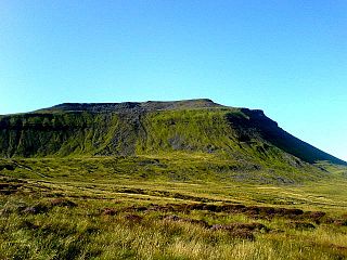
Simon Fell is a subsidiary summit on the north east ridge of Ingleborough, a mountain in the Yorkshire Dales in Northern England. [1]
With a height of 650 metres (2,130 ft) [2] and a prominence of 35 metres (115 ft), it is classified as a Hewitt.
Simon Fell is a subsidiary summit on the north east ridge of Ingleborough, a mountain in the Yorkshire Dales in Northern England. [1]
With a height of 650 metres (2,130 ft) [2] and a prominence of 35 metres (115 ft), it is classified as a Hewitt.

The River Wharfe is a river in Yorkshire, England originating within the Yorkshire Dales National Park. For much of its middle course it is the county boundary between West Yorkshire and North Yorkshire. Its valley is known as Wharfedale.

The Yorkshire Dales are a series of valleys, or dales, in the Pennines, an upland range in England. They are mostly located in the ceremonial county of North Yorkshire, but extend into Cumbria and Lancashire; they are entirely within the historic boundaries of Yorkshire. The majority of the dales are within the Yorkshire Dales National Park, created in 1954. The exception is the area around Nidderdale, which forms the separate Nidderdale Area of Outstanding Natural Beauty.
The mountains of Whernside, Ingleborough and Pen-y-ghent are collectively known as the Three Peaks. The peaks, which form part of the Pennine range, encircle the head of the valley of the River Ribble in the Yorkshire Dales National Park in the North of England.
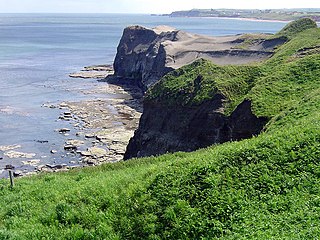
Sandsend Ness is an old alum quarrying site close to Whitby in North Yorkshire, England.

Kisdon Force is a series of waterfalls on the River Swale in Swaledale, England. The falls are situated within the Yorkshire Dales National Park in the county of North Yorkshire, 500 metres downstream from the small hamlet of Keld at grid reference NY898010.
Wain Wath Force is a waterfall on the River Swale in the Yorkshire Dales National Park, North Yorkshire, England. The falls are at grid reference NY883015, 0.6 miles (1 km) upstream from the hamlet of Keld which has three other waterfalls in its vicinity. The names of waterfalls in the north of England often contain "force" after the Old Norse word foss, which means "waterfall".
The Ribble way is a long-distance walk between the Lancashire coast and the Yorkshire Dales National Park largely following the course of the River Ribble.

Ingleton Waterfalls Trail is a well-known circular trail beginning and ending in the village of Ingleton in the English county of North Yorkshire, now maintained by the Ingleton Scenery Company. It is claimed that the trail, some 8 kilometres (5 mi) long, and with a vertical rise of 169 m (554 feet) has some of the most spectacular waterfall and woodland scenery in the north of England. It is on private land and an entrance fee is charged.

Scar End is a settlement on the side of Twisleton Scar in the English county of North Yorkshire.

Strines Reservoir is a water storage reservoir situated at 53.4099°N 1.6557°W, 8 miles (13 km) west of the centre of Sheffield in South Yorkshire, England.

The Craven Fault System is the name applied by geologists to the group of crustal faults in the Pennines that form the southern edge of the Askrigg Block and which partly bounds the Craven Basin. Sections of the system's component faults which include the North, Middle and South Craven faults and the Feizor Fault are evident at the surface in the form of degraded faults scarps where Carboniferous Limestone abuts millstone grit. The fault system is approximately coincident with the southwestern edge of the Yorkshire Dales National Park and the northeastern edge of the Bowland Fells.
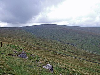
Dodd Fell Hill is a hill in the Yorkshire Dales, in North Yorkshire, England. It is classed as a Marilyn and its summit is at 668 metres (2,192 ft). The flat summit, known as Dodd Fell Hill, is marked by a concrete trig-point. The hill has a lower summit known as Ten End, which is 1.6-kilometre (1 mi) to the north, and slightly lower at 580 metres (1,910 ft) above sea level.

Aire Gap is a pass through the Pennines in England formed by geologic faults and carved out by glaciers. The term is used to describe a geological division, a travel route, or a location that is an entry into the Aire river valley.

Trollers Gill is a limestone gill or gorge in North Yorkshire, England, close to the village of Skyreholme and 4.7 miles (7.5 km) south-east of Grassington in the Yorkshire Dales. The gorge, which is 0.5 miles (0.8 km) in length, is also known as Trollerdale.

Short Drop Cave and Gavel Pot are different entrances into the same cave system on Leck Fell, in Lancashire, England. The main top entrance, Short Drop Cave, is a small hole in a fenced-off shakehole near the main stream sink. Gavel Pot, a window into the system, is a large fenced shakehole some 40-metre (130 ft) deep requiring tackle to descend. There are two other smaller entrances into Short Drop Cave. At its base the system links via a sump with Lost Johns' Cave, and is part of the Three Counties System, an 87 kilometres (54 mi) cave system which spans the borders of Cumbria, Lancashire, and North Yorkshire.

Bar Pot is one of the entrances to the Gaping Gill cave system being located about 340 metres (370 yd) south of Gaping Gill Main Shaft, on Ingleborough in the Yorkshire Dales. It is a popular entrance into the system, being one of the easiest, driest, and having just two vertical pitches to contend with. It lies within the designated Ingleborough Site of Special Scientific Interest.

National Cycle Network (NCN) Route 166 is a Sustrans regional route in the Yorkshire Wolds between Kirkham and Hunmanby. It is one of 5 NCN routes that make up the 146 mile Yorkshire Wolds Cycle Route. Created in 2011 it is fully open and signed.

Newton Dale is a narrow dale within the North York Moors National Park in North Yorkshire, England. It was created by meltwater from a glacier carving the narrow valley. Water still flows through the dale and is known as Pickering Beck.

The Long Kin East Cave - Rift Pot system is a limestone cave system on the southern flanks of Ingleborough, North Yorkshire in England lying within the designated Ingleborough Site of Special Scientific Interest. Long Kin East Cave starts as a long meandering stream passage but then plummets down a 58-metre (190 ft) deep shaft when it meets a shattered fault into which Rift Pot also descends. At the bottom, the stream flows through some low canals and sumps, to eventually emerge at Austwick Beck Head in Crummackdale.

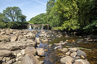
Grassington Bridge is a historic bridge across the River Wharfe in Grassington, a town in North Yorkshire, in England.
54°10′18″N2°22′37″W / 54.1718°N 2.3770°W
| | This North Yorkshire location article is a stub. You can help Wikipedia by expanding it. |