
In aviation, a runway is an elongated, rectangular surface designed for the landing and takeoff of an aircraft. Runways may be a human-made surface or a natural surface. Runways, taxiways and ramps, are sometimes referred to as "tarmac", though very few runways are built using tarmac. Takeoff and landing areas defined on the surface of water for seaplanes are generally referred to as waterways. Runway lengths are now commonly given in meters worldwide, except in North America where feet are commonly used.

In aviation, the instrument landing system (ILS) is a precision radio navigation system that provides short-range guidance to aircraft to allow them to approach a runway at night or in bad weather. In its original form, it allows an aircraft to approach until it is 200 feet (61 m) over the ground, within a 1⁄2 mile (800 m) of the runway. At that point the runway should be visible to the pilot; if it is not, they perform a missed approach. Bringing the aircraft this close to the runway dramatically increases the range of weather conditions in which a safe landing can be made. Other versions of the system, or "categories", have further reduced the minimum altitudes, runway visual ranges (RVRs), and transmitter and monitoring configurations designed depending on the normal expected weather patterns and airport safety requirements.

An airfield traffic pattern is a standard path followed by aircraft when taking off or landing while maintaining visual contact with the airfield.

A non-directional beacon (NDB) or non-directional radio beacon is a radio beacon which does not include inherent directional information. Radio beacons are radio transmitters at a known location, used as an aviation or marine navigational aid. NDB are in contrast to directional radio beacons and other navigational aids, such as low-frequency radio range, VHF omnidirectional range (VOR) and tactical air navigation system (TACAN).

A taxiway is a path for aircraft at an airport connecting runways with aprons, hangars, terminals and other facilities. They mostly have a hard surface such as asphalt or concrete, although smaller general aviation airports sometimes use gravel or grass.

The Wide Area Augmentation System (WAAS) is an air navigation aid developed by the Federal Aviation Administration to augment the Global Positioning System (GPS), with the goal of improving its accuracy, integrity, and availability. Essentially, WAAS is intended to enable aircraft to rely on GPS for all phases of flight, including approaches with vertical guidance to any airport within its coverage area. It may be further enhanced with the Local Area Augmentation System (LAAS) also known by the preferred ICAO term Ground-Based Augmentation System (GBAS) in critical areas.

An instrument landing system localizer, or simply localizer, is a system of horizontal guidance in the instrument landing system, which is used to guide aircraft along the axis of the runway.

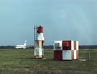
In aviation, a critical area refers to a designated area of an airport that all aircraft, vehicles, persons or physical obstructions must remain clear of when one or more Instrument Landing Systems (ILS) are in use, to protect against signal interference or attenuation that may lead to navigation errors, or accident. Critical areas also protect the ILS system's internal monitoring.

In aviation, an instrument approach or instrument approach procedure (IAP) is a series of predetermined maneuvers for the orderly transfer of an aircraft operating under instrument flight rules from the beginning of the initial approach to a landing, or to a point from which a landing may be made visually. These approaches are approved in the European Union by EASA and the respective country authorities and in the United States by the FAA or the United States Department of Defense for the military. The ICAO defines an instrument approach as "a series of predetermined maneuvers by reference to flight instruments with specific protection from obstacles from the initial approach fix, or where applicable, from the beginning of a defined arrival route to a point from which a landing can be completed and thereafter, if landing is not completed, to a position at which holding or en route obstacle clearance criteria apply."

In aviation, autoland describes a system that fully automates the landing procedure of an aircraft's flight, with the flight crew supervising the process. Such systems enable airliners to land in weather conditions that would otherwise be dangerous or impossible to operate in.
The microwave landing system (MLS) is an all-weather, precision radio guidance system intended to be installed at large airports to assist aircraft in landing, including 'blind landings'. MLS enables an approaching aircraft to determine when it is aligned with the destination runway and on the correct glidepath for a safe landing. MLS was intended to replace or supplement the instrument landing systems (ILS). MLS has a number of operational advantages over ILS, including a wider selection of channels to avoid interference with nearby installations, excellent performance in all weather, a small "footprint" at the airports, and wide vertical and horizontal "capture" angles that allowed approaches from wider areas around the airport.

A marker beacon is a particular type of VHF radio beacon used in aviation, usually in conjunction with an instrument landing system (ILS), to give pilots a means to determine position along an established route to a destination such as a runway.
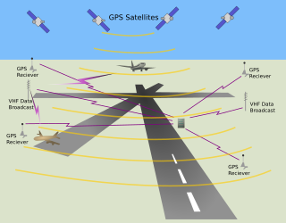
The local-area augmentation system (LAAS) is an all-weather aircraft landing system based on real-time differential correction of the GPS signal. Local reference receivers located around the airport send data to a central location at the airport. This data is used to formulate a correction message, which is then transmitted to users via a VHF Data Link. A receiver on an aircraft uses this information to correct GPS signals, which then provides a standard instrument landing system (ILS)-style display to use while flying a precision approach. The FAA has stopped using the term LAAS and has transitioned to the International Civil Aviation Organization (ICAO) terminology of ground-based augmentation system (GBAS). While the FAA has indefinitely delayed plans for federal GBAS acquisition, the system can be purchased by airports and installed as a Non-Federal navigation aid.

A transponder landing system (TLS) is an all-weather, precision landing system that uses existing airborne transponder and instrument landing system (ILS) equipment to create a precision approach at a location where an ILS would normally not be available.

An approach lighting system (ALS) is a lighting system installed on the approach end of an airport runway and consisting of a series of lightbars, strobe lights, or a combination of the two that extends outward from the runway end. ALS usually serves a runway that has an instrument approach procedure (IAP) associated with it and allows the pilot to visually identify the runway environment and align the aircraft with the runway upon arriving at a prescribed point on an approach.
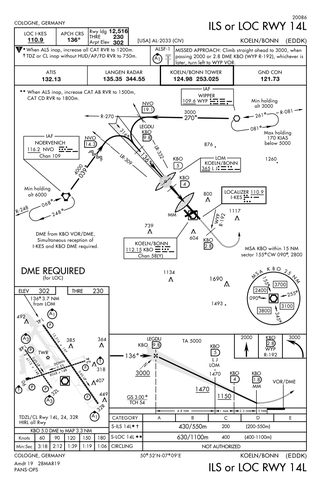
Approach plates are the printed or digital charts of instrument approach procedures that pilots use to fly instrument approaches during instrument flight rules (IFR) operations. Each country maintains its own instrument approach procedures according to International Civil Aviation Organization (ICAO) standards.

Washington County Airport is three miles (5 km) southwest of Washington in South Franklin Township, Pennsylvania. It is owned and operated by Washington County and is in the Greater Pittsburgh metropolitan area.
A localizer type directional aid (LDA) or Instrument Guidance System (IGS) is a type of localizer-based instrument approach to an airport. It is used in places where, due to terrain and other factors, the localizer antenna array is not aligned with the runway it serves. In these cases, the localizer antenna array may be offset (i.e. pointed or aimed) in such a way that the approach course it projects no longer lies along the extended runway centerline (which is the norm for non-offset and non-LDA localizer systems). If the angle of offset is three degrees or less, the facility is classified as an offset localizer. If the offset angle is greater than three degrees, the facility is classified as a localizer-type directional aid (LDA). Straight-in approaches may be published if the offset angle does not exceed 30 degrees. Only circling minima are published for offset angles greater than 30 degrees. As a "directional aid", and only a Category I (CAT I) approach, rather than a full-fledged instrument landing system (ILS), the LDA is more commonly used to help the pilot safely reach a point near the runway environs, where he or she hopefully can see the runway, at which point he or she will proceed and land visually, as opposed to (for example) full Category III (CAT III) ILS systems that allow a pilot to fly, without visual references, very close to the runway surface (usually about 100 ft) depending on the exact equipment in the aircraft and on the ground.

In aeronautics, the final approach is the last leg in an aircraft's approach to landing, when the aircraft is lined up with the runway and descending for landing. In aviation radio terminology, it is often shortened to "final".
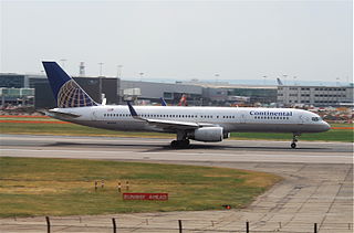
Continental Airlines Flight 1883 was a Boeing 757 that mistakenly landed on a taxiway at Newark Liberty International Airport on the evening of October 28, 2006. There were no reported injuries or damage, but the narrowly averted disaster was investigated by the National Transportation Safety Board, and caused the Federal Aviation Administration to reevaluate and modify air and ground safety procedures at and around Newark Airport.
