
Valais ,,(German; Wallis) more formally the Canton of Valais/Canton of Wallis is one of the 26 cantons forming the Swiss Confederation. It is composed of thirteen districts and its capital and largest city is Sion. The flag of the canton is made of thirteen stars representing the districts, on a white-red background.

The Great St Bernard Pass is the third highest road pass in Switzerland, at an elevation of 2,469 m (8,100 ft). It connects Martigny in the canton of Valais in Switzerland with Aosta in the region Aosta Valley in Italy. It is the lowest pass lying on the ridge between the two highest mountains of the Alps, Mont Blanc and Monte Rosa. It is located on the main watershed that separates the basin of the Rhône from that of the Po.

The Simplon Pass is a high mountain pass between the Pennine Alps and the Lepontine Alps in Switzerland. It connects Brig in the canton of Valais with Domodossola in Piedmont (Italy). The pass itself and the villages on each side of it, such as Gondo, are in Switzerland. The Simplon Tunnel was built beneath the vicinity of the pass in the early 20th century to carry rail traffic between the two countries.

The Gotthard Pass or St. Gotthard Pass at 2,106 m (6,909 ft) is a mountain pass in the Alps traversing the Saint-Gotthard Massif and connecting northern Switzerland with southern Switzerland. The pass lies between Airolo in the Italian-speaking canton of Ticino, and Andermatt in the German-speaking canton of Uri, and connects further Bellinzona and Lugano to Lucerne, Basel, and Zurich. The Gotthard Pass lies at the heart of the Gotthard, a major transport axis of Europe, and it is crossed by three traffic tunnels, each being the world's longest at the time of their construction: the Gotthard Rail Tunnel (1882), the Gotthard Road Tunnel (1980) and the Gotthard Base Tunnel (2016). With the Lötschberg to the west, the Gotthard is one of the two main north-south routes through the Swiss Alps.

Schöllenen Gorge is a gorge formed by the upper Reuss in the Swiss canton of Uri between the towns of Göschenen to the north and Andermatt to the south. It provides access to the St Gotthard Pass.

The Simplon Tunnel is a railway tunnel on the Simplon railway that connects Brig, Switzerland and Domodossola, Italy, through the Alps, providing a shortcut under the Simplon Pass route. It is straight except for short curves at either end. It consists of two single-track tunnels built nearly 15 years apart. The first to be opened is 19,803 m (64,970 ft) long; the second is 19,824 m (65,039 ft) long, making it the longest railway tunnel in the world for most of the twentieth century, from 1906 until 1982, when the Daishimizu Tunnel opened.

Elchingen Abbey was a Benedictine monastery in Oberelchingen in Bavaria, Germany, in the diocese of Augsburg.
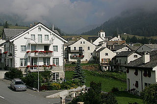
Simplon, earlier known as Simpeln, is a municipality in the district of Brig in the canton of Valais in Switzerland.

The Great Saint Martin Church is a Romanesque Catholic church in Cologne, Germany. Its foundations rest on remnants of a Roman chapel, built on what was then an island in the Rhine. The church was later transformed into a Benedictine monastery. The current buildings, including a soaring crossing tower that is a landmark of Cologne's Old Town, were erected between 1150-1250. The architecture of its eastern end forms a triconch or trefoil plan, consisting of three apses around the crossing, similar to that at St. Maria im Kapitol. The church was badly damaged in World War II; restoration work was completed in 1985.

Weiding is a municipality in the district of Schwandorf in Bavaria, Germany.
There was significant emigration of Swiss people to the Russian Empire from the late 17th to the late 19th century. Rauber (1985) estimates that a number of 50,000 to 60,000 Swiss lived in Russia between roughly 1700 and 1917.

The siege of Kolberg took place from March to 2 July 1807 during the War of the Fourth Coalition, part of the Napoleonic Wars. An army of the First French Empire and several foreign auxiliaries of France besieged the fortified town of Kolberg, the only remaining Prussian-held fortress in the Province of Pomerania. The siege was not successful and was lifted upon the announcement of the Peace of Tilsit.

The Lötschberg line is a railway in Switzerland, connecting Spiez in the canton of Bern with Brig in the canton of Valais. It crosses the Bernese Alps, from the Bernese Oberland to Upper Valais, through the Lötschberg Tunnel in the middle of the line. Together with the Simplon Tunnel south of Brig, it constitutes one of the major railways through the Alps and an important north-south axis in Europe. The Lötschberg axis is backed by the lower and longer Lötschberg Base Tunnel, part of the New Railway Links through the Alps project.

The Reich Chancellery and Führerbunker Complex: An Illustrated History of the Seat of the Nazi Regime is a 2006 book by Steven Lehrer, in which Lehrer recounts the history of a group of Berlin buildings, from their construction in the 18th century until their complete destruction during and after World War II.

The Rhine romanticism was the interpretation of the landscape conditions and history of the Rhine Valley in the cultural-historical period of the romanticism, by the end of the 18th century until the late 19th century and was continued in all forms of art expression.

The Domodossola–Locarno railway line, informally called the Centovallina in Switzerland and the Vigezzina in Italy, is a metre-gauge railway negotiating the dramatic mountainous terrain between Domodossola, Italy, and Locarno, Switzerland. It passes through the Vigezzo Valley and Centovalli.

Eisenach Charterhouse is a former charterhouse, or Carthusian monastery, in Eisenach in Thüringia, Germany, founded in 1378 and suppressed in 1525.

The Compagnie de la Ligne d’Italie, or Ligne d’Italie for short, was a former Swiss railway company that established in 1859. In 1874, the Ligne d'Italie became part of the Compagnie du Simplon. The Compagnie du Simplon, Ligne du Simplon or Simplon for short, merged into the Western Swiss Railways in 1881.

Lake Hopschu is a lake near Simplon Pass in the canton of Valais, Switzerland. Lake Hopschu is located in the area of the municipality of Simplon under the eastern flank of the Tochuhorn and directly on the watershed between the Rhone and the Po. Lake Hopschu is situated in a protected high bog.

The Gondo Gold Mine was the largest gold mine in Switzerland. The mine is located in the south of the canton of Valais near the Italian border at over 1200 m above sea level. In its heyday up to 500 men worked here, while the municipality of Gondo itself had only 100 inhabitants.
