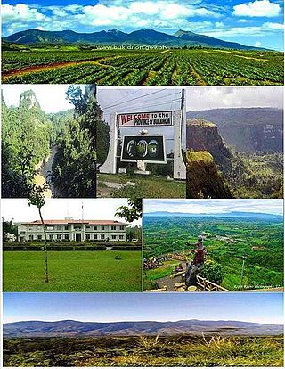
Bukidnon, officially the Province of Bukidnon, is a landlocked province in the Philippines located in the Northern Mindanao region. Its capital is the city of Malaybalay. The province borders, clockwise from the north, Misamis Oriental, Agusan del Sur, Davao del Norte, Cotabato, Lanao del Sur, and Lanao del Norte. According to the 2020 census, the province is inhabited by 1,541,308 residents. The province is composed of 2 component cities and 20 municipalities. It is the third largest province in the country in terms of total area of jurisdiction behind Palawan and Isabela respectively.

Malaybalay, officially the City of Malaybalay, is a 1st class component city and capital of the province of Bukidnon, Philippines. According to the 2020 census, it has a population of 190,712 people.
Libona, officially the Municipality of Libona, is a 1st class municipality in the province of Bukidnon, Philippines. According to the 2020 census, it has a population of 48,965 people.

San Fernando, officially the Municipality of San Fernando, is a 1st class municipality in the province of Bukidnon, Philippines. According to the 2020 census, it has a population of 63,045 people.

Sumilao, officially the Municipality of Sumilao, is a 4th class municipality in the province of Bukidnon, Philippines. According to the 2020 census, it has a population of 29,531 people.
Bangcud is an urban barangay in the South Highway District of Malaybalay City, Bukidnon, in the Philippines.
Cabangahan is an urbanizing barangay in the South Highway District of Malaybalay City, Bukidnon, Philippines. Located 15 kilometres south of the city proper, it is bounded to the north by Aglayan, to the east by Violeta and Simaya, to the south by Bangcud, and to the west by Bugcaon of the Municipality of Lantapan. According to the 2015 census, Cabangahan has a population of 3,015 people. Cabangahan is generally flat with minor undulations near the bank of the Sawaga River. Agriculture is the most common economic activity, with corn, rice, rubber, and sugarcane being the primary crops. There is only one public elementary school which is administered by the Division of Malaybalay City, Schools District VI.

Can-ayan is a rural barangay in the North Highway District of Malaybalay City, Bukidnon, Philippines. According to the 2015 census, Can-ayan has a population of 5,870 people.

Manalog is a rural barangay of the North Highway District of Malaybalay City, Bukidnon, in the Philippines. According to the 2015 census, it has a population of 969 people. It is the northernmost village in Malaybalay, bounded to the north by Barangay Dumalaguing and Barangay Bulonay of Impasugong, to the east by Busdi, to the south by Kibalabag, to the southwest by Kalasungay, and to the west by Barangay Bontongon of Impasugong. Its inhabitants are mostly native Higaunons who has a legal ancestral domain claim in the area. In fact, Manalog is entirely within the Bukidnon Higaonon Tribal Association's (BUHITA) Ancestral Domain.
Apo Macote is a rural barangay in the Basakan District of Malaybalay City, in the province of Bukidnon, Philippines. It is the southernmost barangay of Malaybalay. According to the 2015 census, Apo Macote has a population of 4,903 people.
Miglamin is a rural barangay in the Basakan District of Malaybalay, Bukidnon, Philippines. According to the 2015 census, it has a population of 3,188 people.
Simayà is a barangay in the Basakan District of the city of Malaybalay, Philippines. As of 2015, it has a population of 4,161. It was formerly a sitio of Linabo and was converted into a regular barangay in 1954.
Linabo is an urban barangay in the Basakan District of Malaybalay, Philippines. According to the 2015 census, it has a population of 6,933 people.

Managok is an urbanizing barangay in the Basakan District of Malaybalay, Bukidnon, Philippines. According to the 2015 census, it has a population of 7,200 people.
Mapulo is an urbanizing barangay in the Upper Pulangi District of Malaybalay, Bukidnon, Philippines. According to the 2015 census, it has a population of 1,260 people.
Mapayag is a rural barangay in the South Highway District of Malaybalay, Bukidnon, Philippines. According to the 2015 census, it has a population of 979 people.
San Martin is a rural barangay in the Basakan District of Malaybalay, Bukidnon, Philippines. It is bounded to the north by Managok, to the east by Miglamin, to the south by Sinanglanan and Santo Niño, and to the west by Simaya. San Martin is characterized by a flat terrain with a hilly and rugged terrain in its northern and eastern boundary dominated by Mount Capistrano, a popular attraction in the city, shared with Simayà and Managok. It was a sitio of Linabo known as Macatol until 1951 when it became a regular barrio of Malaybalay.

Malaybalay, the capital of Bukidnon, is subdivided into 46 barangays. The Philippine Standard Geographic Code classifies 15 barangays as urban and 31 rural; however, the City of Malaybalay classifies 18 barangays as urban and 28 rural. These barangays are grouped into five administrative districts, namely Basakan, North Highway, Poblacion, South Highway, and Upper Pulangi.
Santo Niño is a rural barangay in the Basakan District of Malaybalay, Bukidnon, Philippines. According to the 2015 census, it has a population of 1,675 people. It is bordered to the north by Simaya and San Martin, to the east by Sinanglanan and Apo Macote, to the south by Nabag-o of the City of Valencia, and to the west by Bangcud and Mailag.
Violeta is a rural barangay in the Basakan District of Malaybalay, Bukidnon, Philippines. According to the 2015 census, it has a population of 2,199 people. It is bordered to the north by Linabo, to the east by Managok, to the south by Simaya, and to the west by Cabangahan and Aglayan, separated by the Sawaga River.
