Inverpolly is the name given to a large area of northern Wester Ross in the Northwest Highlands of Scotland, north of Ullapool. The area contains several prominent hills, rising up from a rough landscape of bogs and lochans. From 1961, the area was designated national nature reserve but since 2004, the designation has been limited to the area of Knockan Crag. The area supports a large number of high-quality freshwater loch habitats, the majority of which are oligotrophic. Major peaks in the area include Stac Pollaidh, Cul Mòr, Cul Beag. At the heart of Inverpolly lies the large irregular shaped Loch Sionascaig.

Munlochy is a small village, lying at the head of Munlochy Bay, in the Black Isle in Ross and Cromarty, in northern Scotland.

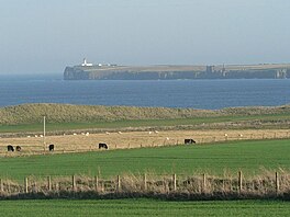
Achnahaird Bay is an inlet of Enard Bay, located on the Coigach peninsula, in Wester Ross, Scotland. It can be accessed by following the road leading to the scattered settlement of Achiltibuie. The wide sandy beach has views of the mountains Stac Pollaidh, Canisp and Suilven. Achnahaird Bay was used as a filming location for the 2011 film The Eagle, where a horse chase scene was shot across the beach.

Loch Inver is a 3.62-kilometre-long sea loch in Assynt, Sutherland and is on the northwest coast of Scotland. The loch meets the coastal embayment of Enard Bay at the north end and The Minch, where it meets Soyea Island at its mouth.

Laide is a small village in the northwest of the Highlands of Scotland. It is situated on the southern shore of Gruinard Bay, about 30 km west of Ullapool.
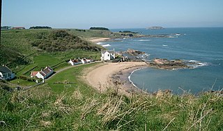
Canty Bay is a small inlet and coastal hamlet on the northern coast of East Lothian, Scotland. It is 2 miles (3.2 km) east of North Berwick and is opposite the Bass Rock and Tantallon Castle. Other settlements nearby include Auldhame, Scoughall, Seacliff, and the Peffer Sands. Canty Bay means "bay of the little head" from the Gaelic ceanntan, diminutive of ceann.

Salen is a settlement on the Isle of Mull, Scotland. It is on the east coast of the island, on the Sound of Mull, approximately halfway between Craignure and Tobermory at the narrowest part of the island. The full name of the settlement is 'Sàilean Dubh Chaluim Chille'. In 1991 it had a population of 500.
Bernisdale is a small township, near the head of Loch Snizort Beag, Isle of Skye in the Highlands and Islands and is in the Scottish council area of Highland.

Invershin is a scattered village in the Parish of Creich, 6 miles (10 km) south of Lairg and 4 miles (6.4 km) north of Bonar Bridge in the south of Sutherland in the Scottish Highlands and is in the Scottish council area of Highland.

Letterfearn is a settlement that lies of the western shore of Loch Duich in Skye and Lochalsh, Highlands of Scotland and is in the council area of Highland. Eilean Donan Castle lies two miles north of Letterfearn.

Largo Bay is a bay on the northern shore of the Firth of Forth, on the coast of Fife, Scotland.
Keiss is a fishing village at the northern end of Sinclair's Bay on the east coast of Caithness in Scotland's Highland Council area.
Whiterow is a small coastal hamlet, on the east coast of Caithness, lying 1 mile southeast of Wick, Scottish Highlands. It is in the Scottish council area of Highland. It lies within the Civil Parish of Wick.

Bualintur is a remote township, which lies at the head of Loch Brittle on the island of Skye in the Highlands of Scotland and is in the Scottish council area of Highland. Accessed only by the Glen Brittle bridge (footbridge) that appears in the Royal Commission on Ancient and Historical Monuments in Scotland Bualintur affords some of the best views of the Cuillin hills, and is the point of access for several of Skye' s most dramatic coastal and forest walks. In recent history it was the central township of Glen Brittle, with the post office and school for the community. It was once a thriving community before the effects of the highland clearances and depopulation of the highlands and islands took place, and many ruined houses can be seen among the existing houses.

Mellon Udrigle is a small remote coastal tourist, fishing and crofting hamlet on the north west coast located in the district of aultbea. Ross-shire, Scottish Highlands and is in the Scottish council area of Highland.

Diabaig is a remote coastal fishing and crofting township in Wester Ross, in the Northwest Highlands of Scotland. Diabaig lies on the north shore of the sea loch of Loch Diabaig, an inlet off the north side of Loch Torridon, and is in the Highland council area.

Badnaban is a remote scattered coastal village, which lies on the south shore of the sea loch, Loch Inver, in the Assynt district of the west coast of Sutherland, Scottish Highlands. and is in the Scottish council area of Highland.
Strathan is a remote scattered coastal village, located in Bàgh an t-strathain Bay, which lies on the south shore of the sea loch, Loch Inver, in the Assynt district of the west coast of Sutherland, Scottish Highlands and is in the Scottish council area of Highland. Strathan is situated less than 1 mile northeast of Badnaban, 1 mile north of Inverkirkaig, and 2 miles southwest of Lochinver

Loch Sionascaig is a large irregular shaped, freshwater loch in the remote Coigach area of northern Wester Ross. It is located 5.5 miles southeast of the village of Lochinver and is situated within the Inverpolly Forest.