Sint-Agatha-Rode

Last updated

Sint-Agatha-Rode
Sint-Agatha-Rode A.jpg
Belgium location map.svg
Red pog.svg
Sint-Agatha-Rode
Location in Belgium
Coordinates: 50°47.2′N04°38′E / 50.7867°N 4.633°E / 50.7867; 4.633
CountryBelgium
Region Flemish Region
Community Flemish Community
Province Flemish Brabant
Municipality Huldenberg
Area
  Total7.23 km2 (2.79 sq mi)
Population
 (1 January 2006) [1]
  Total1,532
  Density210/km2 (550/sq mi)
Postal codes
3040
Area codes 016
Website www.huldenberg.be
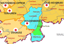
Location of Huldenberg in Flemish Brabant
Huldenberg Flemish-Brabant Belgium Map.svg

Sint-Agatha-Rode, named after the third-century Christian martyr Saint Agatha of Sicily, [2] is a Dutch-speaking village in Belgian province of Flemish Brabant and lies within the district of the town of Huldenberg. [lower-alpha 1] Historically Sint-Agatha-Rode was an independent municipality (Gemeente) until the merger of Belgian municipalities in 1977 when it was joined to the town of Huldenberg.

Contents

Sint-Agatha-Rode is located east of the town centre of Huldenberg, in the hills between the valleys of the river Dijle which is the eastern boundary of the Huldenberg district and the river Laan which is the western boundary. North of the town center of Sint Agatha-Rode the Laan joins the Dyle. The eastern boundary of the village is the language barrier with the Walloon villages of Nethen and Pecrot and to the south is the Flemish village of Ottenburg. Sint-Agatha-Rode has developed from being an agricultural village to become a rural residential town.

Situation of Sint-Agatha-Rode (green) as a part of the greater Huldenberg municipality (blue). Sint-Agatha-Rode.png
Situation of Sint-Agatha-Rode (green) as a part of the greater Huldenberg municipality (blue).

Attractions

The New Chateau of Sint Agatha Rode New Chateau Sint Agatha Rode.JPG
The New Chateau of Sint Agatha Rode
The St. Agatha Church Sint-Agatha-Rode church A.jpg
The St. Agatha Church
Aerial view of the area round the church of Sint-Agatha-Rode Sint-Agatha-Rode aerial photo D.jpg
Aerial view of the area round the church of Sint-Agatha-Rode

Scenery

The Grootbroek nature reserve Sint-Agatha-Rode Grootbroek D.jpg
The Grootbroek nature reserve
The Rodebos nature reserve Rodebos3.jpg
The Rodebos nature reserve

History

Graves of British soldiers in churchyard UK soldiers graves Sint-Agatha-Rode Church.jpg
Graves of British soldiers in churchyard

Notes

  1. After the Battle of Wavre in 1815 the Prussian general Thielemann located his headquarters here, and in contemporary English accounts and some modern ones it is often spelt St Achtenrode. [3]
  1. Source: NIS
  2. 1 2 3 4 5 6 Walton, Denzil (31 October 2012) Red river Flanders Today, Retrieved 25 March 2016
  3. Parkinson 2002, p. 283.
  4. Gobertange sandy limestone Description of Gobertange sandy limestone Belgian stone. Accessed 25 March 2016.
  5. "Sint-Agathakerk Sint-Agatha-Rode (The Sint Agatha church)". Vlaams Brabant. Flemish Brabant Tourism. Retrieved 25 March 2016.
  6. 1 2 3 4 "Huldenberg Brochure", Huldenberg Town Council, October 2006
  7. Open Monumentendag (Open Monument Day) 14 September 2008 Sint Agatha Rode Het Kasteel (The Chateau) accessed on 19 October 2009.
  8. Van Scharen, Kris and Fluyt, Frederik (updated 24 November 2011) The Grootbroek in Sint Agatha Rode Archived 25 April 2012 at the Wayback Machine Nature Study Group Dijleland (in Dutch), Retrieved 14 October 2011
  9. A walk out round the Grootbroek in Sint Agatha Rode Archived 3 March 2016 at the Wayback Machine Accessed 19 October 2009.
  10. "Natuurreservaat Grootbroek (Grootbroek nature reserve)". Vlaams Brabant. Flemish Brabant Tourism. Retrieved 25 March 2016.
  11. "Natuurgebied Rodebos en Laanvallei (The Rodebos nature reserve and the Laan valley)". Vlaams Brabant. Flemish Brabant Tourism. Retrieved 25 March 2016.
  12. Raasen Hans (Updated 17 November 2008) The Rodebos and the Laan Valley Archived 25 April 2012 at the Wayback Machine Nature Study Group Dijleland (in Dutch), Retrieved 11 October 2011
  13. Keersmaeker, Luc De; Baeté, Hans; Christiaens, Bart; Esprit, Marc; Kerckhove, Peter Van De; Vandekerkhove, Kris (2004), Vlaams Natuurreservaat Rodebos en Laanvallei - Monitoringrapport - Monitoring van de dendrometrische gegevens en de vegetatie in een kernvlakte en een transekt. - Summary and figure captions in English, doi:10.13140/RG.2.1.1683.2160
  14. Trappeniers, Jos, Cultural Councillor, (2007) Huldenberg Cultural Plan 2008–2013, 1.4 History [ permanent dead link ] Pp 7–9, (in Dutch) Huldenberg Town Council
  15. 1 2 3 Martens, Eric (1978), "Uit Het Verleden van de gemeente Huldenberg" (From the past of the Town of Huldenberg), (in Dutch) Huldenberg, Printed by L. Vanmelle N.V. Gent, No: D/1978/2789
  16. A photograph of the site of the castle of Sint-Agatha-Rode is shown in Eric Martens 1978 book on page 84
  17. Staff 1st Battalion Royal Welch Fusiliers at Saint-Venant, May 1940 Stories from the museum, Royal Welch Fusilers Regimemental Museum, Retrieved 19 January 2012

Related Research Articles

<span class="mw-page-title-main">Scheldt</span> River in France, Belgium and the Netherlands

The Scheldt is a 435-kilometre-long (270 mi) river that flows through northern France, western Belgium, and the southwestern part of the Netherlands, with its mouth at the North Sea. Its name is derived from an adjective corresponding to Old English sceald ("shallow"), Modern English shoal, Low German schol, West Frisian skol, and obsolete Swedish skäll ("thin").

<span class="mw-page-title-main">Sint-Oedenrode</span> Town in North Brabant, Netherlands

Sint-Oedenrode is a town in the province of North Brabant.

<span class="mw-page-title-main">Mechelen</span> City in the Flemish region of Belgium

Mechelen is a city and municipality in the province of Antwerp in the Flemish Region of Belgium. The municipality comprises the city of Mechelen proper, some quarters at its outskirts, the hamlets of Nekkerspoel (adjacent) and Battel, as well as the villages of Walem, Heffen, Leest, Hombeek, and Muizen. The Dyle flows through the city, hence it is often referred to as the Dijlestad.

<span class="mw-page-title-main">Grimbergen</span> Municipality in Flemish Community, Belgium

Grimbergen is a municipality in the Belgian province of Flemish Brabant, 10 km north of the capital Brussels. It comprises the towns of Beigem, Grimbergen, Humbeek, and Strombeek-Bever. In 2017, it had a population of 37,030 and an area of 38.61 km2, giving a population density of 959 inhabitants per km2.

<span class="mw-page-title-main">Sint-Pieters-Leeuw</span> Municipality in Flemish Community, Belgium

Sint-Pieters-Leeuw is a Dutch-speaking municipality of Belgium located in the province of Flemish Brabant.

<span class="mw-page-title-main">Ternat</span> Municipality in Flemish Community, Belgium

Ternat is a municipality located in the Belgian province of Flemish Brabant. The municipality comprises the villages of Sint-Katherina-Lombeek, Ternat proper and Wambeek. It is also situated in the Pajottenland. On January 1, 2018 Ternat had a total population of 15.481. The total area is 24.48 km² which gives a population density of 597 inhabitants per km².

<span class="mw-page-title-main">Wemmel</span> Municipality in Flemish Community, Belgium

Wemmel is a municipality located in the Belgian province of Flemish Brabant. The municipality only comprises the town of Wemmel proper. On January 1, 2018, Wemmel had a total population of 16,347. The total area is 8.74 km² which gives a population density of 1,870 inhabitants per km².

<span class="mw-page-title-main">Zaventem</span> Municipality in Flemish Community, Belgium

Zaventem is a Belgian municipality in the province of Flemish Brabant. It is located in the Dijleland area, one of the three large recreational areas which together form the Groene Gordel around the Brussels-Capital Region. The municipality comprises the subdivisions or deelgemeenten of Nossegem, Sint-Stevens-Woluwe, Sterrebeek and Zaventem proper. On 1 January 2006 Zaventem had a total population of 28,651. The total area is 27.62 square kilometres, which gives a population density of 1,037 inhabitants per km2. The official language is Dutch as it is within the Flemish Region. Zaventem is the home of Brussels Airport, together with neighbouring town of Diegem.

<span class="mw-page-title-main">Huldenberg</span> Municipality in Flemish Community, Belgium

Huldenberg is a municipality located in the Belgian province of Flemish Brabant. The municipality comprises the towns and villages of Huldenberg proper, Loonbeek, Neerijse, Ottenburg and Sint-Agatha-Rode. On January 1, 2011, Huldenberg had a total population of 9,464. The total area is 39.64 km² which gives a population density of 230 inhabitants per km².

<span class="mw-page-title-main">Rotselaar</span> Municipality in Flemish Community, Belgium

Rotselaar is a municipality located in the Belgian province of Flemish-Brabant, near the convergence of the Demer and the Dijle. Since January 1, 1977 the municipality comprises the towns of Rotselaar proper, Werchter and Wezemaal. On January 1, 2006, Rotselaar had a total population of 15,068. The total area is 37.57 km² which gives a population density of 401 inhabitants per km².

<span class="mw-page-title-main">Waterloo, Belgium</span> Municipality in French Community, Belgium

Waterloo is a municipality in Wallonia, located in the province of Walloon Brabant, Belgium, which in 2011 had a population of 29,706 and an area of 21.03 km2 (8.12 sq mi). Waterloo lies a short distance south of Brussels, and immediately north-east of the larger town of Braine-l'Alleud. It is the site of the Battle of Waterloo, where the resurgent Napoleon was defeated for the final time in 1815. Waterloo lies immediately south of the official language border between Flanders and Wallonia.

<span class="mw-page-title-main">Political parties in Flanders</span>

Flemish political parties operate in the whole Flemish Community, which covers the unilingual Flemish Region and the bilingual Brussels-Capital Region. In the latter, they compete with French-speaking parties that all also operate in Wallonia. There are very few parties that operate on a national level in Belgium. Flanders generally tends to vote for right-wing, conservative parties, whereas in French-speaking Belgium the socialist party is usually the most successful one.

<span class="mw-page-title-main">Dyle (river)</span> River in Belgium

The Dyle is a river in central Belgium, left tributary of the Rupel. It is 86 kilometres (53 mi) long. It flows through the Belgian provinces of Walloon Brabant, Flemish Brabant and Antwerp. Its source is in Houtain-le-Val, near Nivelles in Walloon Brabant.

<span class="mw-page-title-main">Hesbaye</span> Cultural and geophysical region in Belgium

The Hesbaye, or Haspengouw is a traditional cultural and geophysical region in eastern Belgium. It is a loamy plateau region which forms a watershed between the Meuse and Scheldt drainage basins. It has been one of the main agricultural regions in what is now Belgium since before Roman times, and specifically named in records since the Middle Ages, when it was an important Frankish pagus or gau, called Hasbania in medieval Latin.

<span class="mw-page-title-main">French war planning 1920–1940</span>

The Dyle Plan or Plan D was the plan of the Commander-in-Chief of the French Army, Général d'armée Maurice Gamelin, to defeat a German attempt to invade France through Belgium. The Dyle (Dijle) river is 86 km (53 mi) long, from Houtain-le-Val through Flemish Brabant and Antwerp; Gamelin intended French, British and Belgian troops to halt a German invasion force along the line of the river. The Franco-Belgian Accord of 1920 had co-ordinated communication and fortification efforts of both armies. After the German Remilitarization of the Rhineland on 7 March 1936, the Belgian government abrogated the accord and substituted a policy of strict neutrality, now that the German Army was on the German–Belgian border.

<span class="mw-page-title-main">Sophie of Thuringia, Duchess of Brabant</span> German noble (1224–1275)

Sophie of Thuringia was the second wife and only Duchess consort of Henry II, Duke of Brabant and Lothier. She was the heiress of Hesse which she passed on to her son, Henry upon her retention of the territory following her partial victory in the War of the Thuringian Succession in which she was one of the belligerents. Sophie was the founder of the Brabant dynasty of Hesse.

The Hageland is a landscape in the Flemish Region of Belgium, situated in the eastern part of the Province of Flemish Brabant. It is mainly comprised between the cities of Aarschot, Leuven, Tienen and Diest, and probably coincides to some extent with the twelfth-century County of Leuven. The French Government that controlled the area that later became Belgium in the last years of the 18th and early 19th century, had extended Limburg, which since then comprises the minor part of the Hageland at the city of Halen.

<span class="mw-page-title-main">Flanders Heritage Agency</span>

The Flanders Heritage Agency is a cultural heritage agency sponsored by the Flemish Government. The organisation is split into four subdivisions; the former VIOE, which inventories Beschermd erfgoed in the Flemish Region; the agency "Ruimte en Erfgoed" which executes policy on heritage management and protection; the Ministry department of Town and County Planning, Housing Policy and Immovable Heritage, or Ruimtelijke Ordening, Woonbeleid en Onroerend Erfgoed (RWO), which supports the Minister of Culture on policy decisions; and Inspectie RWO, which is the inspection arm of the RWO.

<span class="mw-page-title-main">Noor (Meuse)</span> River in Netherlands, Belgium

The Noor or Langwater is a river in the Netherlands and Belgium. The Noor is a right-bank tributary to the river Voer, which later joins the Meuse. Rising in Eijsden-Margraten, in the Dutch province of Limburg, the Noor eventually drains in the river Voer in Voeren, in the Belgian province of Limburg.

References

Coordinates: 50°47′N4°38′E / 50.783°N 4.633°E / 50.783; 4.633