
Thane is a metropolitan city located on the northwestern side of the state of Maharashtra in India and on the northeastern side of Mumbai. It is an immediate neighbour of Mumbai city proper, and a part of the Mumbai Metropolitan Region. It is situated in the north-eastern portion of the Salsette Island.

Bandra ([bæːɳɖɾa]) is a coastal suburb located in Mumbai, the largest city of the Konkan division in Maharashtra, India. The area is located to the immediate north of the River Mithi, which separates Bandra from the Mumbai City district. It is the third-largest commercial hub in Maharashtra, after the Bombay city district and Pune, primarily aided by the Bandra Kurla Complex.

Kurla is a suburb of East Mumbai, India. It is the headquarters of the Kurla taluka of Mumbai Suburban district. The neighbourhood is named after the eponymous East Indian village that it grew out of. It falls under Zone 5, Ward 'L' of the Bombay Municipal Corporation. Its railway station, spelt as Coorla until 1890, is one of the busiest on the Mumbai suburban railway on the central and harbour railway lines of Mumbai as is the Lokmanya Tilak Terminus (LTT) for out-station passenger/express trains.

Mahim (Marathi: माहिम) is a neighbourhood in Mumbai, Maharashtra, India. The Mahim Junction railway station on the Western Railway and Harbour Railway of the Mumbai Suburban Railway network is the last station of the city, as neighboring Bandra comes in Mumbai Suburb. Mahim is an ethnically and religiously diverse town and has a Hindu temple, church, mosque and Parsi fire-temple existing within a few meters of each other. The town has a large Rich and Upper Middle class Marathi population.

Colaba is a part of the city of Mumbai, India. It is one of the four peninsulas of Mumbai while the other three are Worli, Bandra and Malabar Hill. During Portuguese rule in the 16th century, the island was known as Kolbhat. After the British took over the island in the late 17th century, it was known as Kolio.

The Western Railway is one of the 19 zones of Indian Railways and is among the busiest railway networks in India, headquartered at Mumbai, Maharashtra. The major railway routes of Indian Railways which come under Western Railways are: Mumbai Central–Ratlam, Mumbai Central–Ahmedabad and Palanpur–Ahmedabad. The railway system is divided into six operating divisions: Ahmedabad, Vadodara, Rajkot, Bhavnagar, Ratlam, and Mumbai WR. Vadodara railway station, being the junction point for the Ahmedabad–Mumbai route and the Mumbai–Ratlam route towards New Delhi, is the busiest junction station in Western Railways and one of the busiest junctions of Indian Railways too, while Ahmedabad Division earns highest revenue followed by Mumbai Division and Vadodara Division. Surat railway station is one of the busiest railway station in Western Railway in non-junction category where more than 180 trains pass per day.

Salsette Island is an island in Konkan division of the state of Maharashtra, along India's west coast. Administratively known as Greater Mumbai, the Mumbai Suburban district, Mira Bhayander and a portion of Thane district lie within it, making it very populous and one of the most densely populated islands in the world. It has a population of more than 20 million inhabitants living on an area of about 619 square kilometres (239 sq mi).
The Hornby Vellard was a project to build a causeway uniting all seven islands of Bombay into a single island with a deep natural harbour. The project was started by the governor William Hornby in 1782 and all islands were linked by 1838. The word vellard appears to be a local corruption of the Portuguese word vallado meaning fence or embankment. The seven islets – their anglicised names being Colaba, Old Woman’s Island, Bombay, Mazgaon, Parel, Mahim and Worli – came to the British in 1661 as part of the dowry of Charles II, who married into the Portuguese royal family. Bombay was quickly palmed off to the East India Company for a paltry £10 a year and later the company identified that more land means more money hence got interested in the project.

The Bandra Kurla Complex is a Central business district in the city of Mumbai, India. It is a prominent upscale commercial hub which commands some of the highest property rates in the country. According to MMRDA, the complex is the first of a series of "growth centres" created to "arrest further concentration" of offices and commercial activities in eastern parts of Mumbai. It has aided to decongest the CBD in South Mumbai while seeding new areas of planned commercial real estate in the metropolitan region.

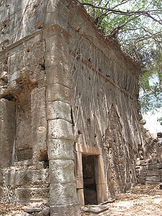
Fort Vasai is a ruined fort of the town of Vasai (Bassein), Konkan Division, Maharashtra, Indian Union. The structure was formally christened as the Fort of St Sebastian in the Indo-Portuguese era. The fort is a monument of national importance and is protected by the Archaeological Survey of India.

Navy Nagar is a cantonment area in Mumbai, India, and was established in 1796. The area is owned and managed solely by the Indian Navy and entry to this area is highly restricted. Entry and exit points to the area are heavily manned by Naval Police.

The Mahim Causeway is a vital link road connecting Mumbai City district/South Mumbai with its Northern and Western Suburbs. The causeway links the neighbourhoods of Mahim to the south with Bandra to the north.
Indigenous tribals have inhabited Mumbai (Bombay) since the Stone Age. The Kolis and Aagri were the earliest known settlers of the islands. Between the 2nd century BCE and 10th century CE, the islands came under the control of successive indigenous dynasties: the Satavahanas, Abhiras, Vakatakas, Kalachuris, Konkan Mauryas, Chalukyas, Rashtrakutas, Silharas & Chollas.
Bombay, also called Bom Bahia or Bom Baim in Indo-Portuguese creole, Mumbai in the local language; is the financial and commercial capital of India and one of the most populous cities in the world. It's also the cosmopolitan city centre of the Greater Bombay Metropolitan Area, and the cultural base of the Bollywood film industry. At the time of arrival of the Portuguese Armadas, Bombay was an archipelago of seven islands. Between the third century BCE and 1348, the islands came under the control of successive Hindu dynasties. The Delhi Sultanate had been ruling the area along with Chaul, New Bombay (Thana) & Damaon, with the administrative centre in Bassein (Vasai) since the raids of Malik Kafur in the Konkan region and across the Indian subcontinent. This territory in North Konkan along with the Bombay islands were later taken over by the Sultan of Guzerat from 1391 to 1534, when he had declared the end of the suzerainty to Delhi, after the Timurid invasion of it. Growing apprehensive of the power of the Moghal emperor Humayun, Sultan Bahadur Shah of Gujarat was obliged to sign the Treaty of Bassein on 23 December 1534; according to which, the seven islands of Bombay, Fort San Sebastian of Bassein in strategic town of Bassein (Vasai), and its dependencies were offered to the Portuguese East Indies. The places were only later officially surrendered on 25 October 1535, by the Sultan of Guzerat.

Bombay, also called Bom baim in Portuguese, is the financial and commercial capital of India and one of the most populous cities in the world.

Church of Our Lady of Good Counsel & Shrine of St. Anthony former Our Lady of Good Counsel Church initially known by its name in Portuguese, Nossa Senhora de Bom Concelho, is one of the oldest churches in, Bombay built by the Portuguese Franciscans. It was built at Sion and was initially affiliated to the St. Michael's Church at Mahim in 1596. The artistically done stained glass windows of the Church portray the martyrdom of Blessed Thomas of Tolentino, Fr. James of Padua, Fr. Peter of Siena, a Cleric and Br. Demetrius of Tiflis at Thane, in April 1321.
Carriage Repair Workshop based at Lower Parel in the city of Mumbai, India is a premier Broad gauge coaching workshop of Central Railway, India. The workshop undertakes the periodic overhauling of passenger main line coaches. It also manufactures wheel sets for the workshop as well as various Locomotives in Mumbai.

HMS Salsette was a Perseverance-class fifth-rate frigate of a nominal 36 guns, launched in 1805. The East India Company built her for the Royal Navy at the company's dockyards in Bombay. She was the Navy's first teak-built ship.

Holy Cross Church, Kurla is a Roman Catholic Church in Kurla, a suburb of Mumbai, India. It was built during the Portuguese era by the Jesuits in 1588 and rebuilt in 1848. It is one of the oldest churches in Mumbai. The church belongs to the Archdiocese of Bombay.

