See also
![]() This article incorporates public domain material from "Sirius Islands". Geographic Names Information System . United States Geological Survey.
This article incorporates public domain material from "Sirius Islands". Geographic Names Information System . United States Geological Survey.
| | This Kemp Land location article is a stub. You can help Wikipedia by expanding it. |
Sirius Islands ( 66°57′S57°27′E / 66.950°S 57.450°E ) is a chain of islands in the north part of the Oygarden Group in Antarctica. Mapped by Norwegian cartographers from aerial photos taken by the Lars Christensen Expedition, 1936–37, and called Nordoyane (the north islands). The group was first visited by an ANARE (Australian National Antarctic Research Expeditions) party in 1954; this chain was renamed by Antarctic Names Committee of Australia (ANCA) after the star Sirius which was used for an astrofix in the vicinity.
![]() This article incorporates public domain material from "Sirius Islands". Geographic Names Information System . United States Geological Survey.
This article incorporates public domain material from "Sirius Islands". Geographic Names Information System . United States Geological Survey.
| | This Kemp Land location article is a stub. You can help Wikipedia by expanding it. |

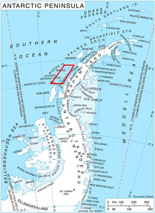
James Ross Island is a large island off the southeast side and near the northeastern extremity of the Antarctic Peninsula, from which it is separated by Prince Gustav Channel. Rising to 1,630 metres (5,350 ft), it is irregularly shaped and extends 40 nautical miles in a north–south direction.

The French Antarctic Expedition is any of several French expeditions in Antarctica.
Cape Hordern is an ice-free cape, overlain by morainic drift, at the northwest end of the Bunger Hills in Antarctica. It was probably sighted from Watson Bluff by A.L. Kennedy and other members of the Western Base Party of the Australasian Antarctic Expedition under Mawson, 1911–1914, who charted the west wall of what appeared to be two small islands lying north of Cape Hoadley in about 100°35′E. It was named "Hordern Island" by Mawson for Sir Samuel Hordern of Sydney, a patron of the expedition. It was renamed Cape Hordern by the Advisory Committee on Antarctic Names (US-ACAN) following correlation of Kennedy's map with the US-ACAN map of 1955 compiled from aerial photographs taken by U.S. Navy Operation Highjump, 1946–47.
Hanusse Bay is a broad, V-shaped bay, off the west coast of Graham Land, Antarctica. The bay is 37 kilometres (20 nmi) long and trends generally north–south. It is bordered by Cape Mascart on Anvers Island, and Shmidt Point on Arrowsmith Peninsula, Loubet Coast. At its north entrance, Isacke Passage separates it from Liard Island. It is bounded to the south by a line from Landauer Point, the north point of Hansen Island and Bagnold Point on Arrowsmith Peninsula.
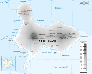
Cape Crozier is the most easterly point of Ross Island in Antarctica. It was discovered in 1841 during James Clark Ross's polar expedition of 1839 to 1843 with HMS Erebus and HMS Terror, and was named after Commander Francis Crozier, captain of HMS Terror, one of the two ships of Ross' expedition.
Prime Head is a prominent snow-covered headland which forms the north extremity of the Antarctic Peninsula.
Hag Pike is a conspicuous rock column, 710 metres (2,330 ft) high, on the north side of the Wordie Ice Shelf near the west coast of the Antarctic Peninsula. Together with the mountain to the north, it forms the west side of the mouth of Hariot Glacier. Hag Pike was photographed from the air by the British Graham Land Expedition, 1937, and by the Ronne Antarctic Research Expedition, 1947. It was surveyed by the Falkland Islands Dependencies Survey, 1948–50, and 1958. The name by the UK Antarctic Place-Names Committee is descriptive, "hag" being the stump of a tree which remains after felling.
The Duroch Islands are a group of islands and rocks which extend over an area of about 3 nautical miles, centred about 1 nautical mile off Cape Legoupil on the north coast of Trinity Peninsula, Antarctica. The islands are close to Chile's Base General Bernardo O'Higgins Riquelme at Cape Legoupil.
The Porthos Range is the second range south in the Prince Charles Mountains of Antarctica, extending for about 30 miles in an east-to-west direction between Scylla Glacier and Charybdis Glacier. First visited in December 1956 by the Australian National Antarctic Research Expeditions (ANARE) southern party under W.G. Bewsher (1956-57) and named after Porthos, a character in Alexandre Dumas, père's novel The Three Musketeers, the most popular book read on the southern journey.
Alphard Island or Meøya is an island 4.6 kilometres (2.5 nmi) long and rising to 150 metres (500 ft), lying north of Shaula Island in the Øygarden Group. It was mapped by Norwegian cartographers from aerial photos taken by the Lars Christensen Expedition, 1936–37, and called "Meøya". It was first visited by an Australian National Antarctic Research Expeditions party led by R. Dovers in 1954; the island was renamed by the Antarctic Names Committee of Australia after the star Alphard, which was used for an astrofix in the vicinity.
The Barcroft Islands are a group of small islands and rocks about 5 miles (8 km) in extent, lying close south of Watkins Island, Biscoe Islands. The group comprises St. Brigid, Irving, St. Isidore, Chakarov, Hervé, Montojo, Alcheh, Leppe and Bedford Islands. The islands were mapped from air photos by the Falkland Islands and Dependencies Aerial Survey Expedition (1956–57), and named by the UK Antarctic Place-Names Committee for Sir Joseph Barcroft, a pioneer investigator of the physiological effects of high altitudes and cold.
The Christiania Islands are a group of islands and rocks between Liège Island and Trinity Island, in the Palmer Archipelago, Antarctica.
Nordwestliche Insel Mountains is a small, detached group of mountains, island-like in appearance, and forming the northern extremity of the Humboldt Mountains, in the Wohlthat Mountains of Queen Maud Land, Antarctica. They lie at the northwest extremity of the Wohlthat Mountains.

Matusevich Glacier is a broad glacier about 50 nautical miles long, with a well developed glacier tongue, flowing to the coast of East Antarctica between the Lazarev Mountains and the northwestern extremity of the Wilson Hills.
Mount Gleadell is a nearly conical ice-free peak, 560 metres (1,840 ft) high, the highest summit on the headland just north of Observation Island at the east side of Amundsen Bay, Antarctica. It was sighted in October 1956 by an Australian National Antarctic Research Expeditions party under P.W. Crohn, and was named for Geoffrey Gleadell, a cook at Mawson Station in 1954.

Cape Hunter is a rocky promontory on the west shore of Commonwealth Bay, Antarctica, 8 nautical miles (15 km) west of Cape Denison. It was discovered in 1912 and explored the following year by the Australasian Antarctic Expedition under Douglas Mawson, who named it for John G. Hunter, chief biologist of the expedition.
Rigel Skerries is a chain of islands and rocks in the northwest part of the Oygarden Group, lying in the south part of the entrance to Edward VIII Bay in Antarctica. Mapped by Norwegian cartographers from aerial photos taken by the Lars Christensen Expedition, 1936–37, and called Utskjera. The group was first visited by an ANARE party in 1954; these skerries were renamed by Antarctic Names Committee of Australia (ANCA) after the star Rigel which was used for an astrofix in the vicinity.
Broken Island is an island 4.6 kilometres long, lying 2.8 km north of Centre Island in the north part of Square Bay, off the west coast of Graham Land. Discovered and named by the British Graham Land Expedition (BGLE) under Rymill, 1934–37.