The Breaksea Islands Group is a group of six islands, in the Southern Ocean, off the southwestern coast of Tasmania, Australia.
The Shanks Islands form a group of five small rocky islets located close to the south-western coast of Tasmania, Australia. Situated near where the mouth of Port Davey meets the Southern Ocean, the islets have a combined area of 2.72 hectares and are part of the Swainson Islands Group. They comprise part of the Southwest National Park and the Tasmanian Wilderness World Heritage Site.

Inner Sister Island, part of the Sister Islands Conservation Area, is a granite and dolerite island, with an area of 748 hectares (2.89 sq mi), located in Bass Strait, Tasmania, Australia.

Outer Sister Island, part of the Sister Islands Conservation Area, is a granite and dolerite island, with an area of 545 hectares (2.10 sq mi), located in Bass Strait, Tasmania, Australia.
Shag Reef, part of the Sister Islands Conservation Area, is a small granite island, with an area of 1.24 hectares located in Bass Strait, Tasmania, Australia.
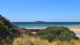
The Lachlan Island, part of the Maria Island Group, is an island with an area of about 2.5 hectares lying close to the south-eastern coast of Tasmania, Australia. The island is located near the Freycinet Peninsula, situated midway between Maria Island and the Tasmanian mainland.
Hen Island is an island located close to the south-western coast of Tasmania, Australia. The 7.6-hectare (0.029 sq mi) island is part of the Maatsuyker Islands Group, and comprises part of the Southwest National Park and the Tasmanian Wilderness World Heritage Site.

The Ile du Golfe is a limestone island located close to the south-western coast of Tasmania, Australia. The long, narrow dolphin-shaped 68-hectare (0.26 sq mi) island is part of the Maatsuyker Islands Group, and comprises part of the Southwest National Park and the Tasmanian Wilderness World Heritage Site.

Walker Island is an island located close to the south-western coast of Tasmania, Australia. The 15-hectare (0.058 sq mi) island is part of the Maatsuyker Islands Group, and comprise part of the Southwest National Park and the Tasmanian Wilderness World Heritage Site.

Flat Top Island is an island located close to the south-western coast of Tasmania, Australia. The 1.58-hectare (0.0061 sq mi) island is part of the Maatsuyker Islands Group, and comprises part of the Southwest National Park and the Tasmanian Wilderness World Heritage Site.
Round Top Island is an island located close to the south-western coast of Tasmania, Australia. The 6.25-hectare (0.0241 sq mi) island is part of the Maatsuyker Islands Group, and comprises part of the Southwest National Park and the Tasmanian Wilderness World Heritage Site.

South East Mutton Bird Islet is a steep unpopulated islet located close to the south-western coast of Tasmania, Australia. Situated 2 kilometres (1.2 mi) south of where the mouth of Port Davey meets the Southern Ocean, the 0.52-hectare (1.3-acre) islet is one of the eight islands that comprise the Mutton Bird Islands Group. The South East Mutton Bird Islet is part of the Southwest National Park and the Tasmanian Wilderness World Heritage Site.
Sugarmouse Island is an unpopulated islet located close to the south-western coast of Tasmania, Australia. Situated some 2 kilometres (1.2 mi) south of where the mouth of Port Davey meets the Southern Ocean, the 0.54-hectare (1.3-acre) islet is one of the eight islands that comprise the Mutton Bird Islands Group. Sugarmouse Island is part of the Southwest National Park and the Tasmanian Wilderness World Heritage Site.
Sugarloaf Rock is a steep, rocky unpopulated islet located close to the south-western coast of Tasmania, Australia. Situated some 2 kilometres (1.2 mi) south of where the mouth of Port Davey meets the Southern Ocean, the 3.56-hectare (8.8-acre) islet is one of the eight islands that comprise the Mutton Bird Islands Group. Sugarloaf Rock is part of the Southwest National Park and the Tasmanian Wilderness World Heritage Site.
Swainson Island is an unpopulated island with an adjacent islet, located close to the south-western coast of Tasmania, Australia. Situated near where the mouth of Port Davey meets the Southern Ocean, the 4.14-hectare (10.2-acre) island is part of the Swainson Islands Group, and comprises part of the Southwest National Park and the Tasmanian Wilderness World Heritage Site.
Lourah Island is an unpopulated island located close to the south-western coast of Tasmania, Australia. Situated within Port Davey, the 4.86-hectare (12.0-acre) island is part of the Swainson Islands Group, and comprises part of the Southwest National Park and the Tasmanian Wilderness World Heritage Site.
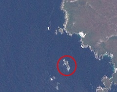
The Fitzroy Islands comprise a group of four rocky islets that lie within the upper reaches of Payne Bay in Port Davey, an oceanic inlet, located in the south west region of Tasmania, Australia. The islands have a combined area of approximately 0.18 hectares and are contained with the Southwest National Park, part of the Tasmanian Wilderness World Heritage Site and the Port Davey/Bathurst Harbour Marine Nature Reserve.
West Pyramid is an unpopulated steep-sided island located close to the south-western coast of Tasmania, Australia. Situated some 1 kilometre (0.62 mi) north of the mouth of Port Davey where it meets the Southern Ocean, the 2.5-hectare (6.2-acre) island is part of the Trumpeter Islets Group, and comprises part of the Southwest National Park and the Tasmanian Wilderness World Heritage Site.
Hobbs Island, also known as Green Island, is an unpopulated island located close to the south-western coast of Tasmania, Australia. Situated some 1 kilometre (0.62 mi) north of where the mouth of Port Davey meets the Southern Ocean, the 9.7-hectare (24-acre) island is part of the Trumpeter Islets Group, and comprises part of the Southwest National Park and the Tasmanian Wilderness World Heritage Site.
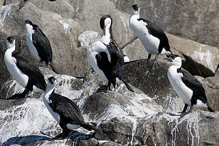
Tasmania's offshore islands: seabirds and other natural features is a book published by the Tasmanian Museum and Art Gallery in 2001. The book is considered an essential measure of the state of Tasmania's islands, birds inhabiting them, and the condition of the islands. The main author was Nigel Brothers, a Hobart based biologist, the other contributors were Vanessa Halley, Helen Pryor, and David Pemberton.
The Tasmanian archipelago is made up of 334 islands. This book highlights the uniqueness and importance of 280, as significant breeding refuges and wealthy natural resources. Islands are documented with descriptions of topography, wildlife, vegetation and full-colour photographs."