Protected areas of Tasmania consist of protected areas located within Tasmania and its immediate onshore waters, including Macquarie Island. It includes areas of crown land managed by Tasmanian Government agencies as well as private reserves. As of 2016, 52% of Tasmania's land area has some form of reservation classification, the majority is managed by the Tasmania Parks & Wildlife Service. Marine protected areas cover about 7.9% of state waters.

Hat Head is a national park on the Mid North Coast of New South Wales, Australia, 461.7 kilometres (286.9 mi) north-east of Sydney. It lies within the Hastings-Macleay Important Bird Area. Within the park is the eponymous village of Hat Head, with about 320 inhabitants.

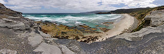
Rocky Cape National Park is a national park on the North West Coast of Tasmania, Australia. It is located at a geographical headland and surrounds the town of Sisters Beach. It is located approximately 365 km by car northwest of State Capital Hobart. In 2016, the official name of the cape was changed to pinmatik / Rocky Cape.
Councils of Tasmania are the 29 administrative districts of the Australian state of Tasmania. Local government areas (LGAs), more generally known as councils, are the tier of government responsible for the management of local duties such as road maintenance, town planning and waste management.

The Tasman Peninsula, officially Turrakana / Tasman Peninsula, is a peninsula located in south-east Tasmania, Australia, approximately 75 km (47 mi) by the Arthur Highway, south-east of Hobart.

Burnie is a port city on the north-west coast of Tasmania, Australia. When founded in 1827, it was named Emu Bay, being renamed after William Burnie, a director of the Van Diemen's Land Company, in the early 1840s.
Waratah-Wynyard Council is a local government body in Tasmania, situated in the north-west of the state. Waratah-Wynyard is classified as a rural local government area and has a population of 13,800, the major towns and localities of the region include Savage River, Sisters Beach, Somerset, Waratah and the principal town of Wynyard.

Wynyard (/ˈwɪnjɚd/) wi-nyuhd) is a rural town located on the North West coast of Tasmania, Australia. Wynyard is situated 17 kilometres (11 mi) west of Burnie. As of the 2021 census, Wynyard has an estimated population of 6,296 The town is a regional hub servicing the surrounding rural areas, the adjacent Burnie Wynyard Airport provides commercial flights to Melbourne and other districts. The main council offices for the Waratah-Wynyard local government area are located in Wynyard.

Somerset is a small township to the west of Burnie, Tasmania, Australia, which shares its name with the County of Somerset, England, UK. Today the city of Burnie encompasses the entire Burnie-Somerset urban area; however, the town is part of the Waratah/Wynyard municipal area.

Warriewood is a suburb in northern Sydney, in the state of New South Wales, Australia. Warriewood is located 26 kilometres north of the Sydney central business district, in the local government area of Northern Beaches Council. Warriewood is part of the Northern Beaches region.

Suffolk Park is a suburb in the Byron Shire of the Northern Rivers region in New South Wales, Australia. It is 5 km south of Byron Bay. At the 2021 Census, its population was 4,222.

The Freycinet Peninsula is a large peninsula located on the eastern coast of Tasmania, Australia. The peninsula is located north of Schouten Island and is contained within the Freycinet National Park.

Burnie City Council is a local government body in Tasmania, located in the city and surrounds of Burnie in the north-west of the state. The Burnie local government area is classified as urban and has a population of 19,348, which also encompasses Cooee, Hampshire, Natone and Ridgley.
The South Coast Track is a bushwalking track located in the South Coast region of Tasmania, Australia. The 85-kilometre (53 mi) track traverses remote wilderness within the Southwest National Park, part of the Tasmanian Wilderness World Heritage Site, and is managed as a wilderness walk. The Tasmanian Parks & Wildlife Service recommend that experienced bushwalkers can take six-to-eight days to cover the track in one direction.
Boat Harbour is a rural locality in the local government area (LGA) of Waratah–Wynyard in the North-west and west LGA region of Tasmania. The locality is about 11 kilometres (6.8 mi) north-west of the town of Wynyard. The 2016 census has a population of 273 for the state suburb of Boat Harbour.
Detention River Christian Community, formerly known as Rocky Cape Christian Community was an Anabaptist Christian community, located between Smithton and Wynyard on the Australian island of Tasmania. The community was founded in 2005 by Elmendorf Christian Community in Minnesota, a community of Hutterite tradition. Detention River was affiliated with the Hutterite Christian Communities.

Table Cape is a extinct volcano located near Wynyard on the North West of Tasmania, Australia, it is also the name of the locality which encompasses the geological feature. Table Cape is a more or less circular extinct volcano with a flat top, its northern and eastern faces rise steeply from Bass Strait to a height of approximately 170 metres (560 ft) above sea level. It was named by British navigator, Matthew Flinders, as he and George Bass circumnavigated Van Diemen's Land in 1798 upon the Norfolk. Flinders also progressively named the nearby Circular Head, Three Hummock and Hunter Islands.

The Detention Falls, a cascade waterfall on the Detention River, is located at Milabena in North West Tasmania, Australia.
Sisters Creek is a locality and small rural community in the local government areas of Waratah-Wynyard and Circular Head, in the North-west and west region of Tasmania. It is located about 18 kilometres (11 mi) north-west of the town of Wynyard. The Bass Highway passes through from east to west, and the watercourse named Sisters Creek flows through from south to north. The 2016 census determined a population of 134 for the state suburb of Sisters Creek.
Rocky Cape is a locality and small rural community in the local government areas of Circular Head and Waratah-Wynyard, in the North-west and west region of Tasmania. It is located about 30 kilometres (19 mi) north-west of the town of Wynyard. The Bass Highway passes through from south-east to north-west. The Rocky Cape National Park is in the north-east of the locality. The 2016 census determined a population of 206 for the state suburb of Rocky Cape.
 Sisters Beach, March 2006

