
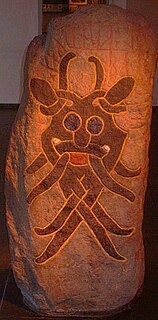
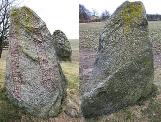
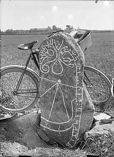
The Sjellebro Stone is a Viking Age image stone located at Sjellbro, which is about 12 kilometers southeast of Randers, Denmark. The stone is inscribed with a facial mask.
The Sjellebro Stone is a Viking Age image stone located at Sjellbro, which is about 12 kilometers southeast of Randers, Denmark. The stone is inscribed with a facial mask.
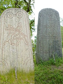
The Sjellbro Stone is about 1.7 meters in height and features the facial mask of a man. Similar to other image stones, today it is difficult to determine the meaning of the inscription. The facial mask on this granite stone is a common motif and is found on several Scandinavian runestones including DR 62 in Sjelle, DR 66 in Århus, DR 81 in Skern, DR 258 in Bösarp, the now-lost DR 286 in Hunnestad, DR 314 in Lund, DR 335 in Västra Strö, Vg 106 in Lassegården, Sö 86 in Åby ägor, Sö 112 in Kolunda, Sö 167 in Landshammar, Sö 367 in Släbro, Nä 34 in Nasta, U 508 in Gillberga, U 670 in Rölunda, U 678 in Skokloster, U 824 in Holms, U 1034 in Tensta, and U 1150 in Björklinge. [1] Of these mask stones, the Sjellebro Stone is the only one without any runic inscription. The Sjellebro Stone was discovered in 1951 lying with its inscription side down. [2] It is located near where a ford existed for a Viking Age road that crossed a small river. [2] The inscription is dated as having been carved between 850-1050 C.E. based on the style of the mask, which is classified as being in the Mammen style. [2]
The stone is known locally as the Sjellebrostenen. The stone has been listed in catalogs as either DK MJy 69 or DR EM1985;539.
U 678 is the Rundata catalog number for a Viking Age image stone with a runic inscription located in Skokloster, Uppland, Sweden.
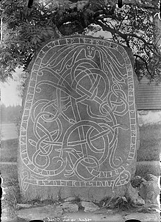
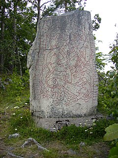
Danish Runic Inscription 66 or DR 66, also known as the Mask stone, is a granite Viking Age memorial runestone that was discovered in Aarhus, Denmark. The inscription features a facial mask and memorializes a man who died in a battle.

The Tullstorp Runestone is a Viking Age memorial runestone, listed as DR 271 in the Rundata catalog, that is located in Tullstorp, which is about twenty kilometers east of Trelleborg, Skåne County, Sweden, and in the historic province of Scania.

Uppland Runic Inscription 1034 or U 1034 is the Rundata catalog number for a runic inscription on a runestone located at the Tensta Church, which is three kilometers northwest of Vattholma, Uppsala County, Sweden, and in the historic province of Uppland, that was carved in the late 11th or early 12th century. While the tradition of carving inscriptions into boulders began in the 4th century and lasted into the 12th century, most runestones date from the late Viking Age.

The Fyrby Runestone, which is designated as Sö 56 in the Rundata catalog, is a Viking Age memorial runestone located in Fyrby, which is about 15 kilometers south of Flen, Södermanland County, Sweden, and in the historic province of Södermanland.
Sö 86 is the Rundata catalog number for a Viking Age memorial runic inscription located in Åby, which is about one kilometer north of Ålberga, Södermanland County, Sweden, and in the historic province of Södermanland. The inscription features a depiction of the hammer of the Norse pagan god Thor named Mjöllnir and a facial mask.
The Lund 1 Runestone, designated as DR 314 in the Rundata catalog, is a Viking Age memorial runestone originally located on the grounds of the All Saints Church in Lund, Scania, Sweden.

The Hørdum stone is a Viking Age picture stone discovered in Hørdum, Thisted Municipality, North Denmark Region, Denmark, that depicts a legend from Norse mythology involving the god Thor and Jörmungandr, the Midgard serpent.

The Holmby Runestone, listed as DR 328 in the Rundata catalog, is a Viking Age memorial runestone with an image of a ship that is located in Holmby, which is about 2 kilometers southeast of Flyinge, Scania, Sweden.

Östergötland Runic Inscription 224 or Ög 224 is the Rundata catalog number for a Viking Age memorial runestone that is located in Stratomta, which is 9 kilometers east of Linköping, Östergötland, Sweden. The runestone has an inscription on two sides with an image of a ship on the south side.

The Sønder Kirkeby Runestone, listed as runic inscription DR 220 in the Rundata catalog, is a Viking Age memorial runestone that was discovered in Sønder Kirkeby, which is located about 5 kilometers east of Nykøbing Falster, Denmark.

Södermanland Runic Inscription 158 or Sö 158 is the Rundata catalog number for a Viking Age memorial runestone located in Österberga, which is one kilometer southwest of Ärsta and three kilometers southwest of Runtuna, Södermanland County, Sweden, and in the historic province of Södermanland. The inscription includes an image of a ship and uses same-stave bind runes to commemorate a man described as being a thegn.
The Västra Strö 2 Runestone, listed as DR 335 in the Rundata catalog, is a Viking Age memorial runestone located at the Västra Strö Monument, which is at a church that is about four kilometers northwest of Eslöv, Skåne County, Sweden.
Uppland Runic Inscription 824 is the Rundata catalog number for a Viking Age memorial runestone located at Holms, which is about eight kilometers east of Örsundsbro, Uppsala County, Sweden, and in the historic province of Uppland. The inscription features a facial mask and a bind rune in the text.
Södermanland Runic Inscription 367 or Sö 367 is the Rundata catalog designation for a Viking Age memorial runestone located in Släbro, which is one kilometer north of Nyköping, Södermanland County, Sweden, which was in the historic province of Södermanland. The inscription has a facial mask and describes two men as being thegns and the owners of Sleðabrú, which today is modern day Släbro.

Östergötland Runic Inscription MÖLM1960;230 or Ög MÖLM1960;230 is the Rundata catalog number for a memorial runestone that is located near a church in Törnevalla, which is 2 kilometers east of Linghem, Östergötland County, Sweden, which was in the historic province of Östergötland. The runestone has an inscription which refers to a Viking Age mercantile guild and depicts a ship.
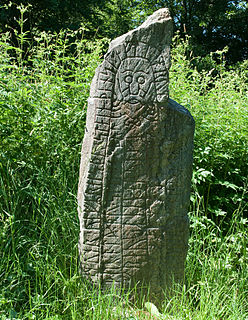
The Skern Runestone, designated as Danish Runic Inscription 81 or DR 81 in the Rundata catalog, is a Viking Age memorial runestone located in the small village of Skjern, Denmark between Viborg and Randers. The stone features a facial mask and a runic inscription which ends in a curse. A fragment of a second runestone designated as DR 80 was also found in Skjern.
Västmanland Runic Inscription 17 or Vs 17 is the Rundata designation for a Viking Age memorial runestone with an image of a ship that is located in Råby, which is about two kilometers east of Tortuna, Västmanland County, Sweden, which was in the historic province of Västmanland.
The Nasta Runestone, listed as Nä 34 in the Rundata catalog, is a Viking Age memorial runestone located in Nasta, which is 3 kilometers northwest of Glanshammar, Örebro County, Sweden, which was in the historic province of Närke.

The Ålum Runestones are four Viking Age memorial runestones which are located at the church in Ålum, which is 9 km west of Randers, Denmark. One of the stones refers to a man with the title drengr and two of the other stones were raised by the same family.
| Wikimedia Commons has media related to Sjellebro Stone . |