Sjøholt

Last updated
Sjøholt
Village

Sjoholt.JPG

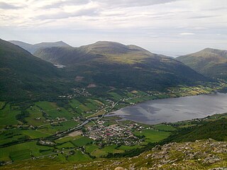
View of Sjøholt, looking west
Norway More og Romsdal location map.svg
Red pog.svg
Sjøholt
Location in Møre og Romsdal
Norway location map.svg
Red pog.svg
Sjøholt
Sjøholt (Norway)
Coordinates: 62°29′01″N06°48′38″E / 62.48361°N 6.81056°E / 62.48361; 6.81056 Coordinates: 62°29′01″N06°48′38″E / 62.48361°N 6.81056°E / 62.48361; 6.81056
Country Norway
Region Western Norway
County Møre og Romsdal
District Sunnmøre
Municipality Ørskog
Area [1]
  Total 1.37 km2 (0.53 sq mi)
Elevation [2] 3 m (10 ft)
Population (2013) [1]
  Total 1,436
  Density 1,048/km2 (2,710/sq mi)
Time zone CET (UTC+01:00)
  Summer (DST) CEST (UTC+02:00)
Post Code6240 Ørskog

Sjøholt is the administrative centre of Ørskog Municipality in Møre og Romsdal county, Norway. The village is located along the northern shore of the Storfjorden, about 10 kilometres (6.2 mi) east of the village of Skodje. The village of Stordal is located about 18 kilometres (11 mi) to the south, through several tunnels. Sjøholt is located roughly halfway between the towns of Ålesund and Molde, along European route E39 and European route E136.

An administrative centre is a seat of regional administration or local government, or a county town, or the place where the central administration of a commune is located.

Møre og Romsdal County (fylke) of Norway

Møre og RomsdalUrban East Norwegian: [²møːrə ɔ ˈrʊmsdɑːl](listen) is a county in the northernmost part of Western Norway. It borders the counties of Trøndelag, Oppland and Sogn og Fjordane. The county administration is located in the town of Molde, while Ålesund is the largest town. The county is governed by the Møre og Romsdal County Municipality which includes an elected county council and a county mayor. The national government is represented by the county governor.

Norway constitutional monarchy in Northern Europe

Norway, officially the Kingdom of Norway, is a Nordic country in Northwestern Europe whose territory comprises the western and northernmost portion of the Scandinavian Peninsula; the remote island of Jan Mayen and the archipelago of Svalbard are also part of the Kingdom of Norway. The Antarctic Peter I Island and the sub-Antarctic Bouvet Island are dependent territories and thus not considered part of the kingdom. Norway also lays claim to a section of Antarctica known as Queen Maud Land.

The 1.37-square-kilometre (340-acre) village has a population (2013) of 1,436; giving the village a population density of 1,048 inhabitants per square kilometre (2,710/sq mi). [1] The village is home to furniture, wood, and plastics industries. The regional high school and Ørskog Church are also located here. [3] The newspaper Bygdebladet is published in Sjøholt. [4] [5]

Population density A measurement of population numbers per unit area or volume

Population density is a measurement of population per unit area or unit volume; it is a quantity of type number density. It is frequently applied to living organisms, and most of the time to humans. It is a key geographical term. In simple terms population density refers to the number of people living in an area per kilometer square.

Ørskog Church Church in Møre og Romsdal, Norway

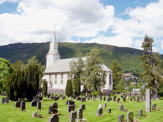
Ørskog Church is a parish church in Ørskog Municipality in Møre og Romsdal county, Norway. It is located in the village of Sjøholt. The church is part of the Ørskog parish in the Austre Sunnmøre deanery in the Diocese of Møre. The white wooden church was built in 1873 by the architect Jacob Wilhelm Nordan. This church is the most recent in a series of churches located on this site dating back to at least the 13th century.

Bygdebladet is a newspaper published in Sjøholt in Møre og Romsdal county, Norway. The newspaper is published in Nynorsk and is issued on Wednesdays and Saturdays in the municipalities of Vestnes, Ørskog, Stordal, Skodje, and Haram. The paper was started in 1972 by Kjell Opsal. Opsal edited the paper until 2015, when he was succeeded by Reidar Opsal.

Related Research Articles

Stordal Municipality in Møre og Romsdal, Norway

Stordal is a municipality in Møre og Romsdal county, Norway. It is part of the Sunnmøre region. The administrative centre of the municipality is the village of Stordal. The historic farm and museum of Ytste Skotet lies along the Storfjorden in the western part of the municipality. Most of the municipality lies on the eastern side of the fjord.

Sykkylven Municipality in Møre og Romsdal, Norway

Sykkylven is a municipality in Møre og Romsdal county, Norway. It is part of the Sunnmøre region. The administrative centre is the village of Aure. Other villages in the municipality include Ikornnes, Straumgjerde, and Tusvik.

Skodje Municipality in Møre og Romsdal, Norway

Skodje is a municipality in Møre og Romsdal county, Norway. It is part of the Sunnmøre region. The administrative centre is the village of Skodje. The other main village in the municipality is Valle.

Vestnes Municipality in Møre og Romsdal, Norway

Vestnes is a municipality in Møre og Romsdal county, Norway. Vestnes is part of the traditional district of Romsdal. The administrative centre of the municipality is the village of Vestnes. Other villages in the municipality include Vikebukt, Vik, Øverås, Fiksdal, Tomrefjord, and Tresfjord.

Sandane Village in Western Norway, Norway

Sandane is the administrative centre of the municipality of Gloppen in Sogn og Fjordane county, Norway. It is located at the end of the Gloppefjorden, along the European route E39 highway. Sandane is 20 kilometres (12 mi) south of the village of Nordfjordeid and about 16 kilometres (9.9 mi) west of the village of Byrkjelo. Sandane Airport, Anda is located 10 kilometres (6.2 mi) northwest of Sandane along highway E39. Sandane has several suburban areas that surround the nearby fjord such as Sørstranda to the west and Vereide to the northwest.

Vikeså Village in Western Norway, Norway

Vikeså or Vigjeså is the administrative centre of Bjerkreim municipality in Rogaland county, Norway. The village is located along the European route E39 highway at a crossroads with the village of Ålgård about 20 kilometres (12 mi) to the northwest, the village of Dirdal about 25 kilometres (16 mi) to the northeast, and the town of Egersund about 20 kilometres (12 mi) to the south. The lake Svelavatnet lies along the south side of the village.

Batnfjordsøra Village in Western Norway, Norway

Batnfjordsøra is the administrative centre of Gjemnes Municipality in Møre og Romsdal county, Norway. The village is located at the end of the Batnfjorden at the mouth of the river Batnfjordelva. European Route E39 passes through the village on its way from Molde to Trondheim. The 0.32-square-kilometre (79-acre) village has a population (2013) of 319, which gives the village a population density of 997 inhabitants per square kilometre (2,580/sq mi).

Valle, Møre og Romsdal Village in Western Norway, Norway

Valle is a village in Skodje Municipality in Møre og Romsdal county, Norway. The village is located on the eastern end of the island of Oksenøya, along the northern shore of the Storfjorden. Valle sits along the European route E39/European route E136 highway, about 5 kilometres (3.1 mi) south of the municipal center of Skodje, 28 kilometres (17 mi) east of the city of Ålesund, and 11 kilometres (6.8 mi) west of Sjøholt in Ørskog Municipality.

Skjold, Rogaland Village in Western Norway, Norway

Skjold is a village in Vindafjord municipality in Rogaland county, Norway. The village is located at the northern end of the Skjoldafjorden, along the European route E134 highway, about 25 kilometres (16 mi) northeast of the town of Haugesund. Skjold Church is located in the village. The village was the administrative centre of the old municipality of Skjold which existed from 1838 until 1965.

Etnesjøen Village in Western Norway, Norway

Etnesjøen or Etne is the administrative centre of Etne municipality in Hordaland county, Norway. The village is located at the inner end of the Etnefjorden, along the European route E134 highway, about 8 kilometres (5.0 mi) south of the village of Skånevik and about 10 kilometres (6.2 mi) northeast of the village of Ølensjøen.

Vikebukt Village in Western Norway, Norway

Vikebukt is a village in Vestnes Municipality in Møre og Romsdal county, Norway. The village is located along the eastern side of the mouth of the Tresfjorden, just south of where the fjord meets the Romsdalsfjorden. The village is the site of Vike Church. The 0.53-square-kilometre (130-acre) village has a population (2013) of 250, giving the village a population density of 472 inhabitants per square kilometre (1,220/sq mi).

Stordal (village) Village in Western Norway, Norway

Stordal is the administrative centre of Stordal Municipality in Møre og Romsdal county, Norway. The village is located on the eastern shore of the Storfjorden at the mouth of the river Stordalselva. The village of Sjøholt lies about 16 kilometres (9.9 mi) north of Stordal, on the other side of the Stordal Tunnel. The historic mountain farm, Ytste Skotet, lies about 6 kilometres (3.7 mi) to the northwest, across the fjord.

Stranda, Møre og Romsdal Village in Western Norway, Norway

Stranda is the administrative centre of Stranda Municipality in Møre og Romsdal county, Norway. The village is located on the western shore of the Storfjorden. The 2.38-square-kilometre (590-acre) village has a population (2013) of 2,907; giving the village a population density of 1,221 inhabitants per square kilometre (3,160/sq mi), and making it the largest settlement in the municipality.

Stordal Tunnel

The Stordal Tunnel is a 3,530-metre (11,580 ft) long road tunnel in Stordal Municipality, Møre og Romsdal county, Norway. The tunnel is located on Norwegian County Road 650, on the eastern shore of the Storfjorden. The tunnel goes through the mountain Stamneshornet between the village of Dyrkorn on the north end and it exits the mountain about 1.5 kilometres (0.93 mi) northwest of the village of Stordal.

Skånevik (village) Village in Western Norway, Norway

Skånevik is a village in Etne municipality in Hordaland county, Norway. The village is located along the Skånevikfjorden, near the entrance to the Åkrafjorden. The village lies across the fjord from the village of Utåker in neighboring Kvinnherad municipality. The municipal centre of Etnesjøen lies about 8 kilometres (5.0 mi) straight south across a mountain, although one must drive about 22 kilometres (14 mi) around the mountain to get there.

Førre Village in Western Norway, Norway

Førre or Førresfjorden is a village in Tysvær municipality in Rogaland county, Norway. The village is located at the northern end of the Førresfjorden. A portion of the urban area of this village extends over the municipal border into neighboring Karmøy municipality. The 3.6-square-kilometre (890-acre) village has a population (2014) of 5,362 which gives the village a population density of 1,489 inhabitants per square kilometre (3,860/sq mi).

Sunnmøringen is a local Norwegian newspaper published twice a week in the municipality of Stranda in Møre og Romsdal county.

References