Skeppsholmsbron

Last updated
Gilded crown on Skeppsholmsbron with Strandvagen in the background. Skeppsholmsbron Stockholm Crown Strandvagen.jpg
Gilded crown on Skeppsholmsbron with Strandvägen in the background.
Gilded crown on the western side Gilded Crown on Skeppsholmsbron.jpg
Gilded crown on the western side

Skeppsholmsbron (Swedish: "The Skeppsholm Bridge") is in central Stockholm, Sweden, connecting Blasieholmen to Skeppsholmen.

Contents

The bridge, 165 metres long and 9.5 metres wide, consists of a 5.5 metre wide roadway flanked by 2 metre pathways, and has 5 arches. [1] It was the first forged iron bridge to be constructed in Sweden, manufactured by Motala Verkstad in 1861. [2]

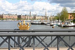
The Gilded Crowns on Skeppsholmsbron are a set of two crowns at the midpoint of the bridge. The crown is a symbol of Sweden and the Royal Family of Sweden and it can be clearly seen on the Coat of arms of Sweden.

The first bridge to connect Skeppsholmen to the rest of the city was a wooden bridge on poles, simply called Holmbron ("The Islet Bridge") and provided with a drawbridge, constructed by the admiralty in 1638-1640 when the camp of the Swedish Navy was relocated from Blasieholmen to Skeppsholmen. In 1822 the bridge was damaged in a fire, and subsequently replaced by a temporary pontoon bridge. Funded directly and still owned by the state, the present steel bridge was finally inaugurated in 1861. [1]

In 1935 the bridge together with other building and structures on Skeppsholmen and Kastellholmen were classified as historical landmarks, thus prohibiting replacing the bridge or altering its exterior, a decision nevertheless reassessed in the 1990s. [3]

See also

Related Research Articles

<span class="mw-page-title-main">Vasabron</span>

Vasabron is a bridge over Norrström in central Stockholm, Sweden connecting Norrmalm to Gamla stan, the old city.

<span class="mw-page-title-main">Strömbron</span>

Strömbron is a 140-metre-long (460 ft) viaduct in central Stockholm, Sweden. Stretching over Norrström, it is connecting the old city Gamla stan to the northern-central district Norrmalm, or, more specifically, to Blasieholmen near the park Kungsträdgården.

<span class="mw-page-title-main">Stadshusbron</span>

Stadshusbron, formerly known as Nya Kungsholmsbron is a bridge in central Stockholm, Sweden located just north of the Stockholm City Hall. Stretching over Klara sjö, it connects mainland Norrmalm on the eastern shore to the island Kungsholmen on the western shore.

<span class="mw-page-title-main">Klarabergsviadukten</span> Viaduct in central Stockholm, Sweden

Klarabergsviadukten is a reinforced concrete bridge and an overpass in central Stockholm, Sweden. Stretching over Klara Sjö, it connects Norrmalm to Kungsholmen.

<span class="mw-page-title-main">Kungsbron</span>

Kungsbron is a double bridge in central Stockholm, Sweden. Stretching over Klara Sjö, it connects Norrmalm to Kungsholmen.

<span class="mw-page-title-main">Barnhusbron</span>

Barnhusbron is a bridge in central Stockholm, Sweden. Passing over Barnhusviken, it connects Kungsholmen to Norrmalm. It is 23 metres wide and 290 metres long with a maximum span of 64.5 metres. The roadway is made of prestressed concrete except for two non-tensioned concrete section in its eastern end.

<span class="mw-page-title-main">Sankt Eriksbron</span>

Sankt Eriksbron is a bridge in central Stockholm, Sweden. Passing over Barnhusviken it connects Kungsholmen to Norrmalm. The present construction was inaugurated in 1937. Neighbouring bridges are: Kungsbron, Barnhusbron, Stadshusbron, Klarabergsviadukten, and Ekelundsbron.

<span class="mw-page-title-main">Kastellholmsbron</span>

Kastellholmsbron is a small bridge in central Stockholm, Sweden, connecting the small island Kastellholmen to Skeppsholmen.

<span class="mw-page-title-main">Ekelundsbron</span>

Ekelundsbron is a bridge in Stockholm, Sweden. Passing over the canal Karlbergskanalen, it connects the city district Stadshagen on Kungsholmen to the northern suburb Solna.

<span class="mw-page-title-main">Djurgårdsbrunnsbron</span>

Djurgårdsbrunnsbron is a bridge in central Stockholm, Sweden, connecting northern and southern Djurgården. It is the city's only remaining swing bridge, the default bridge type in Stockholm during the 19th century. It has been closed since 1966.

<span class="mw-page-title-main">Mariebergsbron</span> Bridge

Mariebergsbron is a bridge in central Stockholm, Sweden. Formerly known as Lilla Essingebron, it connects the islands Kungsholmen to Lilla Essingen. The current name is due to the vicinity to the city district Marieberg.

<span class="mw-page-title-main">Essingebron</span>

Essingebron are two parallel bridges in central Stockholm, Sweden, inaugurated August 21, 1966, and September 3, 1967. Forming a section of the Essingeleden motorway they connect the two islands Stora Essingen and Lilla Essingen and are the most heavily trafficked bridges in Sweden. The current bridges replaced a bridge called Stora Essingebron inaugurated on May 10, 1965, as the motorway being built then resulted in a number of bridges connecting to Stora Essingen and the name was considered ambiguous.. The motorway bridges are paralleled by a bridge for local use, Gamla Essinge Broväg.

<span class="mw-page-title-main">Långholmsbron</span>

Långholmsbron is a bridge in central Stockholm, Sweden. Connecting the major island Södermalm to the minor island Långholmen, it forms an extension to the street Bergsundsgatan.

<span class="mw-page-title-main">Pålsundsbron</span>

Pålsundsbron is a bridge in central Stockholm, Sweden. Stretching over the small water course Pålsundet, the bridge connects the major island Södermalm to the minor island Långholmen.

<span class="mw-page-title-main">Ålkistan</span>

Ålkistan is the name of a canal, and the surrounding area, north of Stockholm, Sweden. The canal connects Lilla Värtan to Lake Brunnsviken, and delimits Bergshamra, the northern part of Solna, from the northern part of Djurgården.

<span class="mw-page-title-main">Danviksbro</span>

Danviksbron or, alternatively, Danviksbro is a bascule bridge in central Stockholm, Sweden, connecting the eastern end of Södermalm to the eastern municipality Nacka. Under the bridge, the canal Hammarbykanalen carries the water of Hammarby Sjö over to Saltsjön. The bridge, actually two separate bridges, carries the railway Saltsjöbanan and a road.

<span class="mw-page-title-main">Johanneshovsbron</span>

Johanneshovsbron is a 756 metres long and 17,9 metres wide road bridge in central Stockholm, Sweden. Overpassing two older bridges, Skansbron and Skanstullsbron, and one newer bridge, Fredriksdalsbron, it connects Södermalm and the tunnel passing under it, Söderledstunneln, to Johanneshov, the district immediately south of the historical city centre, and national road 73, leading out of the city.

Liljeholmsbron is a bridge in central Stockholm, Sweden. Stretching over Liljeholmsviken, it connects the western end of the major island Södermalm to the southern mainland district Liljeholmen.

<span class="mw-page-title-main">Fredhällsbron</span>

Fredhällsbron is a bridge in central Stockholm, Sweden. It connects the island Lilla Essingen to Fredhäll, a district on the island Kungsholmen, and, forming a section of the Essingeleden motorway, connects the Lilla Essingen interchange to the tunnel Fredhällstunneln.

<span class="mw-page-title-main">Sickla kanalbro</span>

Sickla kanalbro is a bridge in central Stockholm, Sweden. Stretching over Sickla kanal, it connects Södra Hammarbyhamnen to Nacka. The name Sickla is believed to be derived from a 15th-century provincial word, sik, meaning "minor marsh".

References

  1. 1 2 Dufwa, Arne (1985). "Broar och viadukter: Skeppsholmbron". Stockholms tekniska historia: Trafik, broar, tunnelbanor, gator. Uppsala: Stockholms gatukontor and Kommittén för Stockholmsforskning. pp. 191–192. ISBN   91-38-08725-1.
  2. "Skeppsholmen". Stockholms gatunamn (2nd ed.). Stockholm: Kommittén för Stockholmsforskning. 1992. p. 199. ISBN   91-7031-042-4.
  3. Swedish language Wikipedia : Skeppsholmsbron, January 8, 2007

Coordinates: 59°19′38″N18°04′45″E / 59.32722°N 18.07917°E / 59.32722; 18.07917