| Skrim | |
|---|---|
 | |
| Highest point | |
| Elevation | 859 m (2,818 ft) |
| Coordinates | 59°30′54″N9°35′15″E / 59.5150°N 9.5876°E |
| Geography | |
| Location | Buskerud, Norway |
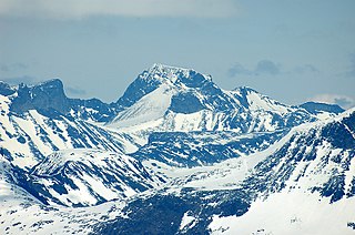
Skrim is a mountain of Kongsberg municipality, Buskerud, in southern Norway. [1]
| Skrim | |
|---|---|
| | |
| Highest point | |
| Elevation | 859 m (2,818 ft) |
| Coordinates | 59°30′54″N9°35′15″E / 59.5150°N 9.5876°E |
| Geography | |
| Location | Buskerud, Norway |
Skrim is a mountain of Kongsberg municipality, Buskerud, in southern Norway. [1]

Preikestolen or Prekestolen is a tourist attraction in the municipality of Strand in Rogaland county, Norway. Preikestolen is a steep cliff which rises 604 metres (1,982 ft) above Lysefjorden. Atop the cliff, there is an almost flat top of approximately 25 by 25 metres. Preikestolen is located near the Western part of the fjord, and on its North side.
Galdhøpiggen is the highest mountain in Norway, Scandinavia, and Northern Europe. The 2,469-metre-tall (8,100 ft) mountain is located in Lom Municipality in Innlandet county, Norway. It is in the Jotunheimen mountains within Jotunheimen National Park. The mountain sits about 25 kilometres (16 mi) southwest of the village of Fossbergom and about 45 kilometres (28 mi) northeast of the village of Øvre Årdal. The mountain is surrounded by several other notable mountains including Keilhaus topp to the east; Store Styggehøe to the southeast; Svellnosbreahesten, Midtre Tverråtinden, and Store Tverråtinden to the south; Storjuvtinden and Skardstinden to the west; Veslpiggen, Storgrovtinden, and Storgrovhøe to the northwest; and Galdhøi and Juvvasshøi to the northeast.

A hulder is a seductive forest creature found in Scandinavian folklore. Her name derives from a root meaning "covered" or "secret". In Norwegian folklore, she is known as huldra. She is known as the skogsrå "forest spirit" or Tallemaja "pine tree Mary" in Swedish folklore, and ulda in Sámi folklore. Her name suggests that she is originally the same being as the völva divine figure Huld and the German Holda.
Rondane National Park is the oldest national park in Norway, established on 21 December 1962. The park is located in Innlandet county, in the municipalities of Dovre, Folldal, Sel, Nord-Fron, Sør-Fron, Stor-Elvdal, and Ringebu. The park contains ten peaks above 2,000 metres (6,560 ft), with the highest being Rondeslottet at an altitude of 2,178 m (7,146 ft). The park is an important habitat for herds of wild reindeer.
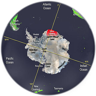
New Swabia was an area of Antarctica explored and briefly claimed by Nazi Germany within the Norwegian territorial claim of Queen Maud Land in early 1939. The region was named after the expedition's ship, Schwabenland, itself named after the German region of Swabia. Although the name "New Swabia" is occasionally mentioned in historical contexts, it is not an officially recognized cartographic name in modern use. The area is now part of Queen Maud Land, governed under the Antarctic Treaty System.
Dovrefjell–Sunndalsfjella National Park is a National Park in Norway. It was established in 2002 to replace and enlarge the former Dovrefjell National Park which had been established in 1974. The park occupies 1,693 square kilometres (654 sq mi) and encompasses areas in three Norwegian counties: Innlandet, Trøndelag, and Møre og Romsdal and includes large parts of the mountain range of Dovrefjell along with the Sunndalsfjella mountains. Together with the National Park, there are eight landscape protected areas and two biotope protected areas that were established adjacent to the park in 2002, comprising a total protected area of 4,366 square kilometres (1,686 sq mi). The park itself lies within the municipalities of Dovre and Lesja, Oppdal municipality, and Sunndal and Molde municipalities.
Glittertind or Glittertinden is a mountain in Lom Municipality in Innlandet county, Norway. The 2,452-metre (8,045 ft) tall mountain is the second highest mountain in Norway. It is located in the Jotunheimen mountains within Jotunheimen National Park. The mountain sits about 22 kilometres (14 mi) southeast of the village of Fossbergom and about 38 kilometres (24 mi) southwest of the village of Vågåmo. The mountain is surrounded by several other notable mountains including Trollsteineggje, Trollsteinrundhøe, and Svartholshøe to the north; Grotbreahesten to the northeast; Veslekjølen to the east; Austre Hestlægerhøe and Nautgardstinden to the southeast; Steinbukampen and Veopallan to the south; and Galdhøpiggen to the west.

Halti is a fell at the border between Norway and Finland. The peak of the fell, called Ráisduottarháldi, is in Norway, on the border Nordreisa Municipality and Gáivuotna Municipality (Kåfjord), about one kilometre north of the border with Finland. The highest point of the fell on the Finnish side is at 1,324 m (4,344 ft) above sea level, and thus the highest point in the country. The Finnish side of Halti belongs to the municipality of Enontekiö in the province of Lapland.

Slogen is a mountain rising up from Hjørundfjorden in the municipality of Ørsta in Møre og Romsdal county, Norway. The mountain is located just west of the municipal boundary with Stranda and just north of the nearby mountain Jakta. Many famous Norwegians have been on the top of this mountain, including most notably Queen Sonja of Norway.

The geography of Norway is dominated by vast mountain ranges broken up by valleys and fjords. Less than 10% of the country's area is arable, and the rest is mountainous. Glaciers are the major cause for erosion, so the terrain in the Norwegian mountains consists of plateaus and lakes with peaks. These areas have an abundant and diverse fauna and flora.

Snøhetta is the highest mountain in the Dovrefjell mountain range in Norway. At 2,286 metres (7,500 ft), it is the highest mountain in Norway outside the Jotunheimen range, making it the 24th highest peak in Norway, based on a 30-metre (98 ft) topographic prominence cutoff. At 1,675 metres (5,495 ft), its topographic prominence is the third highest in Norway.

Fannaråki is a mountain in the municipality of Luster in Vestland county, Norway. The 2,068-metre (6,785 ft) tall mountain is located in the Jotunheimen National Park, just south of the lake Prestesteinsvatnet and the Sognefjellsvegen road. This mountain is located about 6 kilometres (3.7 mi) north of the Skagastølstindane mountains.
Besseggen or Besseggi is a mountain ridge in Vågå Municipality in Innlandet county, Norway. The 1,634-metre (5,361 ft) tall mountain ridge is located in the Jotunheimen mountains within Jotunheimen National Park. The mountain sits about 46 kilometres (29 mi) southwest of the village of Vågåmo and about 30 kilometres (19 mi) northwest of the village of Beitostølen. The mountain ridge is surrounded by several other notable mountains including Veslfjellet to the east and Besshø to the northwest. The ridge runs between the lakes Gjende and Bessvatnet.

Rondslottet is the highest mountain in the Rondane mountain range in Innlandet county, Norway. The 2,178-metre (7,146 ft) tall mountain sits on the border between Dovre Municipality and Folldal Municipality, just north of the border with Sel Municipality. There is a trail leading to the summit.

Jiehkkevárri is a mountain on the border of Lyngen Municipality and Tromsø Municipality in Troms county, Norway. It is the highest mountain in Troms and has the second highest prominence among Norwegian mountains. The 1,834-metre (6,017 ft) tall mountain sits about 10 kilometres (6.2 mi) northeast of the village of Lakselvbukt and about 17 kilometres (11 mi) southwest of the village of Lyngseidet.

Stetinden (Norwegian) or Stáddá (Lule Sami) is a mountain in Narvik Municipality in Nordland county, Norway. It is located about 15 kilometres (9 mi) northeast of the village of Kjøpsvik. The mountain has very smooth sides reaching all the way to the fjord. Stetinden has an obelisk-shape which gives it a very distinct look. In 2002 it was voted to be the "National Mountain" of Norway by listeners of NRK.

Romsdalshornet is a mountain in the municipality of Rauma in Møre og Romsdal county, Norway. The mountain is located 10 kilometres (6.2 mi) southeast of the town of Åndalsnes, along the Rauma River in the Romsdalen valley. The Rauma railway line and the European route E136 highway both pass by the mountain. The mountain Store Venjetinden lies 3 kilometres (1.9 mi) east of the mountain and 3 kilometres (1.9 mi) to the west lies the mountain Store Trolltind—part of the Troll Wall/Trollryggen ridge.
Store Lenangstind or Store Lenangstinden is a mountain in Lyngen Municipality in Troms county, Norway. It is within the Lyngen Alps mountain range and has the fourth-highest primary factor in Norway. It is located about 15.5 kilometres (9.6 mi) northwest of the village of Lyngseidet, just west of the Lyngenfjorden. The Strupbreen glacier lies along the southeastern side of the mountain.
Orm Stórolfsson, also known as Orm Stórolfsson the Strong, was an Icelandic strongman who gained considerable attention during his lifetime for extraordinary feats of strength. He is documented in the Icelandic saga book to have walked three steps with the mast of Ormrinn Langi, weighing 650 kilograms (1,433 lb) and 10 metres (33 ft) in length, on his shoulders before breaking his back. According to legend, it took some 50 men to place the ship's mast on his shoulders due to its extreme weight and it had been an arduously difficult task to keep the log in balance because of its immense length. It had also been said that he never walked again after performing this feat.

The Norwegian Athletics Championships is an annual outdoor track and field competition organised by the Norwegian Athletics Association, which serves as the national championship for the sport in Norway. Royal trophies (Kongepokal) are given to the most outstanding male and female athletes of the competition.
| | This article about a mountain, mountain range, or peak in Buskerud is a stub. You can help Wikipedia by expanding it. |