Related Research Articles

An oil spill is the release of a liquid petroleum hydrocarbon into the environment, especially the marine ecosystem, due to human activity, and is a form of pollution. The term is usually given to marine oil spills, where oil is released into the ocean or coastal waters, but spills may also occur on land. Oil spills may be due to releases of crude oil from tankers, offshore platforms, drilling rigs and wells, as well as spills of refined petroleum products and their by-products, heavier fuels used by large ships such as bunker fuel, or the spill of any oily refuse or waste oil.

Mountaintop removal mining (MTR), also known as mountaintop mining (MTM), is a form of surface mining at the summit or summit ridge of a mountain. Coal seams are extracted from a mountain by removing the land, or overburden, above the seams. This process is considered to be safer compared to underground mining because the coal seams are accessed from above instead of underground. In the United States, this method of coal mining is conducted in the Appalachian Mountains in the eastern United States. Explosives are used to remove up to 400 vertical feet of mountain to expose underlying coal seams. Excess rock and soil is dumped into nearby valleys, in what are called "holler fills" or "valley fills".

Surface mining, including strip mining, open-pit mining and mountaintop removal mining, is a broad category of mining in which soil and rock overlying the mineral deposit are removed, in contrast to underground mining, in which the overlying rock is left in place, and the mineral is removed through shafts or tunnels.
The Florida Institute of Oceanography (FIO), located on the campus of the University of South Florida St. Petersburg, is an entity of the State University System of Florida that works collaboratively with 32 institutions and agencies from across the state that support marine research.
Monitoring, control and surveillance (MCS), in the context of fisheries, is defined by the Food and Agriculture Organization (FAO) of the United Nations as a broadening of traditional enforcing national rules over fishing, to the support of the broader problem of fisheries management.
CleanSeaNet (CSN) is a satellite-based monitoring system for marine oil spill detection and surveillance in European waters.
The West Cork oil spill was an oil spill off the southern coast of Ireland. The spill was first identified by the European Maritime Safety Agency's CleanSeaNet satellite monitoring system on 14 February 2009. An Irish Air Corps marine patrol aircraft confirmed the slick's presence near the Admiral Kuznetsov which was undergoing refuelling around the same time. The British Coastguard and Irish Department of Transport agreed that around 300 tonnes of oil were spilled. The Russian Navy accepted responsibility for the incident but disputed the quantity, claiming around 20-30 tonnes had been spilt either whilst washing the decks or pumping out the bilges of the carrier, the Russian Navy made no notification to any authority at the time of the spill. The oil spill drifted eastwards and there were fears that the spill would wash up on the coast of south eastern Ireland or Wales but it broke up before this.

The Montara oil spill was an oil and gas leak and subsequent slick that took place in the Montara oil field in the Timor Sea, off the northern coast of Western Australia. It is considered one of Australia's worst oil disasters. The slick was released following a blowout from the Montara wellhead platform on 21 August 2009, and continued leaking until 3 November 2009, when the leak was stopped by pumping mud into the well and the wellbore cemented thus "capping" the blowout. The West Atlas rig is owned by the Norwegian-Bermudan Seadrill, and operated by PTTEP Australasia (PTTEPAA), a subsidiary of PTT Exploration and Production (PTTEP) which is in turn a subsidiary of PTT, the Thai state-owned oil and gas company was operating over on adjacent well on the Montara platform. Houston-based Halliburton was involved in cementing the well. The Montara field is located off the Kimberley coast, 250 km (160 mi) north of Truscott airbase, and 690 km (430 mi) west of Darwin. Sixty-nine workers were safely evacuated from the West Atlas jackup drilling rig when the blowout occurred.

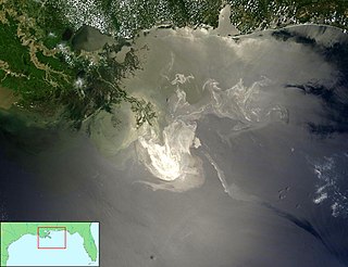
The Deepwater Horizon oil spill was an environmental disaster which began on 20 April 2010, off the coast of the United States in the Gulf of Mexico on the BP-operated Macondo Prospect, considered the largest marine oil spill in the history of the petroleum industry and estimated to be 8 to 31 percent larger in volume than the previous largest, the Ixtoc I oil spill, also in the Gulf of Mexico. Caused in the aftermath of a blowout and explosion on the Deepwater Horizon oil platform, the United States federal government estimated the total discharge at 4.9 MMbbl. After several failed efforts to contain the flow, the well was declared sealed on 19 September 2010. Reports in early 2012 indicated that the well site was still leaking. The Deepwater Horizon oil spill is regarded as one of the largest environmental disasters in world history.

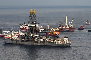
On April 20, 2010, an explosion and fire occurred on the Deepwater Horizon semi-submersible mobile offshore drilling unit, which was owned and operated by Transocean and drilling for BP in the Macondo Prospect oil field about 40 miles (64 km) southeast off the Louisiana coast. The explosion and subsequent fire resulted in the sinking of the Deepwater Horizon and the deaths of 11 workers; 17 others were injured. The same blowout that caused the explosion also caused an oil well fire and a massive offshore oil spill in the Gulf of Mexico, considered the largest accidental marine oil spill in the world, and the largest environmental disaster in United States history.

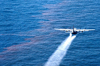
Corexit is a product line of oil dispersants used during oil spill response operations. It is produced by Nalco Holding Company, an indirect subsidiary of Ecolab. Corexit was originally developed by the Standard Oil Company of New Jersey. Corexit is typically applied by aerial spraying or spraying from ships directly onto an oil slick. On contact with the dispersant, oil that would otherwise float on the surface of the water is emulsified into tiny droplets and sinks or remains suspended in the water. In theory this allows the oil to be more rapidly degraded by bacteria (bioremediation) and prevents it from accumulating on beaches and in marshes.

This article covers the effect of the Deepwater Horizon disaster and the resulting oil spill on global and national economies and the energy industry.
Following is a Timeline of the Deepwater Horizon oil spill for May 2010.

The Health consequences of the Deepwater Horizon oil spill are health effects related to the explosion of the Deepwater Horizon offshore drilling rig in the Gulf of Mexico on April 20, 2010. An oil discharge continued for 84 days, resulting in the largest oil spill in the history of the petroleum industry, estimated at approximately 206 million gallons. The spill exposed thousands of area residents and cleanup workers to risks associated with oil fumes, particulate matter from Controlled burns, volatile organic compounds (VOCs), polycylic aromatic hydrocarbons (PAHs), and heavy metals.

The Deepwater Horizon oil spill was discovered on the afternoon of 22 April 2010 when a large oil slick began to spread at the former rig site. According to the Flow Rate Technical Group, the leak amounted to about 4.9 million barrels of oil, exceeding the 1989 Exxon Valdez oil spill as the largest ever to originate in U.S.-controlled waters and the 1979 Ixtoc I oil spill as the largest spill in the Gulf of Mexico. BP has challenged this calculation saying that it is overestimated as it includes over 810,000 barrels of oil which was collected before it could enter the Gulf waters.
The MT Castillo de Bellver oil spill began on 6 August 1983, when the Spanish tanker caught on fire off Saldanha Bay, approximately 70 miles northwest of Cape Town, South Africa. It was carrying 250,000 tonnes of light crude oil, and was traveling through an environmentally sensitive area known for its seabird rookeries and important commercial fishing grounds. The burning vessel was abandoned and broke apart after drifting offshore. Three crew were lost. The stern capsized and sunk and the bow was sunk using explosives. A total of 145,000-170,000 tonnes of oil entered the sea. Onshore impacts were considered negligible as the slick traveled seaward. The only visible impact was the oiling of 1,500 gannets that were on a nearby island.
Fossil fuel regulations are part of the energy policy in the United States and have gained major significance with the nation's strong dependence on fossil fuel-based energy. Regulatory processes are established at the federal and state level due to the immense economic, socio-political and environmental impact of fossil fuel extraction and production. Over 80% of the United States' energy comes from fossil fuels such as coal, natural gas, and oil. The Bush administration was marked by the Energy Policy Act of 2005, which provided a monetary incentive for renewable energy adoption and addressed the issue of climate change. The Obama administration was made up of advocates for renewable energy and natural gas, while Donald Trump built his campaign on promises to revive the coal industry.

Environmental issues in Appalachia, a cultural region in the Eastern United States, include long term and ongoing environmental impact from human activity, and specific incidents of environmental harm such as environmental disasters related to mining. A mountainous area with significant coal deposits, many environmental issues in the region are related to coal and gas extraction. Some extraction practices, particularly surface mining, have met significant resistance locally and at times have received international attention.
The 2004 Taylor Energy oil spill is an ongoing spill located in the Gulf of Mexico, around 11 miles (18 km) off the coast of the U.S. state of Louisiana. It is the result of the destruction of a Taylor Energy oil platform during Hurricane Ivan in 2004. It is the longest-running oil spill in U.S. history. It was first brought to public attention when contamination at the site was noticed in 2010 by those monitoring the nearby Deepwater Horizon oil spill. A report by the Associated Press in 2015 challenged the estimates of the extent of the leak originally given by the company and the U.S. Coast Guard (USCG), which were then revised to be around 1,000 times greater than initially reported.
References
- ↑ "Home". skytruth.org.
- ↑ Tucker, Neely; Tucker, Neely (2013-07-31). "SkyTruth, the environment and the satellite revolution". The Washington Post. ISSN 0190-8286 . Retrieved 2017-05-22.
- ↑ "About – SkyTruth". skytruth.org. 9 June 2016. Retrieved 2017-05-22.
- ↑ Tucker, Neely; Tucker, Neely (2013-07-31). "SkyTruth, the environment and the satellite revolution". The Washington Post. ISSN 0190-8286 . Retrieved 2017-05-22.
- ↑ "About – SkyTruth". skytruth.org. 9 June 2016. Retrieved 2017-05-22.
- ↑ "Gulf Oil Spill "Not Over": Dolphins, Turtles Dying in Record Numbers". 2014-04-09. Archived from the original on April 11, 2014. Retrieved 2017-05-22.
- ↑ Cart, Julie (2010-05-01). "Tiny group has big impact on spill estimates". Los Angeles Times. ISSN 0458-3035 . Retrieved 2017-05-22.
- ↑ "Tracking Frackers From the Sky". Smithsonian. Retrieved 2017-05-22.
- ↑ "Johns Hopkins study links fracking to premature births, high-risk pregnancies". The Hub. 2015-10-12. Retrieved 2017-05-22.
- ↑ Desmon, Stephanie (2016-08-25). "Study: Fracking associated with migraines, fatigue, chronic nasal and sinus symptoms". The Hub. Retrieved 2017-05-22.
- ↑ Revkin, Andrew C. "How Digital Tracking of Rogue Fishing Can Safeguard Vast Ocean Reserves". Dot Earth Blog. Retrieved 2017-05-22.
- ↑ "Satellite watchers busted an illegal fishing vessel, and they're coming for others around the world". Business Insider. Retrieved 2017-05-22.
- ↑ "Appalachian Voices Releases Mountaintop Mining Mapping Tool". Associated Press. Retrieved 2017-05-22.
- ↑ Evans, Michael J. (November 4, 2021). "Linking mountaintop removal mining to water quality for imperiled species using satellite data". PLOS ONE. 16 (11): e0239691. Bibcode:2021PLoSO..1639691E. doi: 10.1371/journal.pone.0239691 . PMC 8568141 . PMID 34735447.
- ↑ Grey Ellis, Emma. "Thousands of Invisible Oil Spills Are Destroying the Gulf". Wired. Retrieved 2017-05-22.